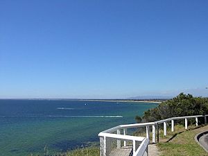
Beaches in Port Phillip facts for kids
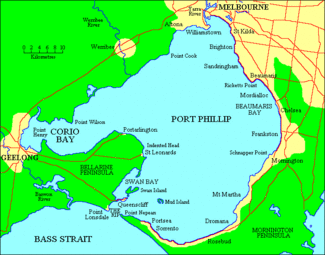
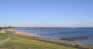
Port Phillip is a large bay in Victoria, Australia. It's a popular spot because of its many beaches. Most of these beaches are flat, shallow, and long. This means the waves are usually very small, making them super safe for swimming!
Because the beaches are so safe and fun, lots of families visit Port Phillip during summer and school holidays. You can enjoy water sports like body boarding and even surfing here. It's usually pretty easy, unless the weather gets really wild.
You'll find most of the sandy beaches on the northern, eastern, and southern sides of the bay. The western side has some sandy beaches too, but it also has different kinds of areas like swampy wetlands and mangroves. Sometimes, you might even find a pebble beach or some easy sand dunes, especially towards the southern parts of the bay.
Contents
- Exploring the Beaches of Port Phillip
- Beaches in Hobsons Bay
- Beaches Between Hobsons and Beaumaris Bays
- Beaches in Beaumaris Bay
- Beaches Between Beaumaris and Dromana Bays
- Beaches in Dromana Bay
- Beaches in Capel Sound
- Beaches Near Point Nepean
- Beaches in Lonsdale Bay
- Beaches Between Lonsdale and Corio Bays
- Beaches in Corio Bay
- Beaches Between Corio and Altona Bays
- Beaches in Altona Bay
Exploring the Beaches of Port Phillip
Port Phillip Bay is home to many different beaches, each with its own charm. Let's take a look at some of the popular areas around the bay.
Beaches in Hobsons Bay
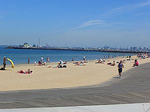
This area has several well-known beaches that are easy to get to from the city.
- Yarra River (This is where the river meets the bay)
- Sandridge Beach - Port Melbourne
- Port Melbourne Beach - Port Melbourne
- South Melbourne Beach - Albert Park
- West Beach - St Kilda West
- St Kilda Beach - St Kilda
Beaches Between Hobsons and Beaumaris Bays
Moving south, you'll find a stretch of beautiful beaches, perfect for a day out.
- Elwood Beach - Elwood
- Seacombe Grove Beach - Brighton
- Middle Brighton Beach - Brighton
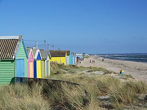
- Dendy Street Beach - Brighton (famous for its colourful beach boxes!)
- Brighton Beach - Brighton
- Hampton Beach - Hampton
- Sandringham Beach - Sandringham
- Half Moon Bay Beach - Black Rock
- Black Rock Beach - Black Rock
- Ricketts Point Beach - Beaumaris (This area is also a marine sanctuary, great for exploring sea life!)
- Watkins Bay Beach
- Keefers Cove Beach
Beaches in Beaumaris Bay
This part of the bay offers long, sandy stretches, ideal for swimming and relaxing.
- Mentone Beach - Mentone
- Parkdale Beach - Parkdale
- Mordialloc Beach - Mordialloc
- Aspendale Beach - Aspendale
- Edithvale Beach - Edithvale
- Chelsea Beach - Chelsea
- Bonbeach Beach - Bonbeach
- Carrum Beach - Carrum
- Seaford Beach - Seaford
- Long Island Beach
- Frankston Beach - Frankston
- South Frankston Beach - Frankston/Frankston South
Beaches Between Beaumaris and Dromana Bays
As you head further down the Mornington Peninsula, the beaches become even more scenic.
- Daveys Bay Beach - Mount Eliza
- Mount Eliza Beach - Mount Eliza
- Canadian Bay Beach
- Half Moon Bay Beach - Mount Eliza
- Ranelagh Beach - Mount Eliza
- Moondah Beach - Mount Eliza
- Sunnyside North Beach - Mount Eliza
- Sunnyside Beach - Mount Eliza
- Mills Beach - Mornington
- Mills Beach East
- Shire Hall Beach - Mornington
- Mothers Beach - Mornington
- Royal Beach - Mornington
- Fishermans Beach - Mornington
- Fosters Beach - Mornington
- Fosters Slip
- Fossil Beach - Mornington
- Dava Beach - Mount Martha
- Birdrock Beach - Mount Martha
- Craigie Beach - Mount Martha
- Hawker Beach - Mount Martha
- Mount Martha Beach North - Mount Martha
- Mount Martha Beach South - Mount Martha
Beaches in Dromana Bay
This area is known for its calm waters and beautiful views of the bay.
- Pebble Cove Beach - Mount Martha
- Safety Beach - Safety Beach
- Dromana Beach - Dromana
- Anthonys Nose Beach - Dromana
Beaches in Capel Sound
These beaches are popular holiday spots with long stretches of sand.
- McCrae Beach - McCrae
- Rosebud Beach - Rosebud
- Rosebud West Beach - Rosebud West
- Tootgarook Beach - Tootgarook
- Rye Beach - Rye
- Rye Beach East
- Rye Beach West
- Tyrone Beach - Rye
- Blairgowrie Beach - Blairgowrie
- Camerons Bight Beach - Sorrento
- Sullivan Bay Beach - Sorrento
- Sorrento Front Beach - Sorrento
- Policemans Point Beach - Sorrento
Beaches Near Point Nepean
This area is at the very tip of the Mornington Peninsula, where the bay meets the ocean.
- Shelley Beach - Portsea
- Portsea Front Beach - Portsea
- Ticonderoga Beach - Portsea
- Observatory Point Beach - Portsea (Be careful, the sand dunes here can be unstable!)
- Nepean Bay Beaches - Portsea (These beaches are dangerous and not open to the public.)
- The Rip (This is the narrow, often rough, entrance to Port Phillip Bay)
Beaches in Lonsdale Bay
On the western side of the bay's entrance, you'll find these beaches.
- The Rip
- Pier Beach - Point Lonsdale
- Point Lonsdale Front Beach - Point Lonsdale
- Springs Beach - Point Lonsdale
- Narrows Beach - Queenscliff (This is an approved dog beach!)
- Santa Casa Beach - Queenscliff
- Queenscliff Beach - Queenscliff
Beaches Between Lonsdale and Corio Bays
This stretch of coastline offers more quiet and natural beach experiences.
- The Bluff Beach - St Leonards
- St Leonards Beach - St Leonards
- Indented Head Beach - Indented Head
- Half Moon Bay Beach - Indented Head
- Indented Head Northern Beaches - Indented Head
- Portarlington Eastern Beaches - Portarlington
- Portarlington Beach - Portarlington
- The Dell - Clifton Springs
Beaches in Corio Bay
Corio Bay is home to Geelong's city beaches and other spots.
- Point Henry Beaches - Moolap
- Eastern Beach - Geelong (A popular swimming spot with a promenade)
- Western Beach - Geelong
- Rippleside Beach - Rippleside
- St Helens Beach - North Geelong
- Limeburners Bay Beach - Corio
- Avalon Beach - Avalon
Beaches Between Corio and Altona Bays
Much of this coastline is less developed. It includes areas used for military facilities or water treatment.
- Werribee South Beach - Werribee South
- Campbells Cove Beaches - Werribee South
Beaches in Altona Bay
Closer to Melbourne's western suburbs, these beaches are popular for local recreation.
- Altona Beach - Altona
- Seaholme Beach - Seaholme
- Williamstown Beach - Williamstown
- Shelley Beach - Williamstown
- Yarra River (Another point where the Yarra River meets the bay)


