Beartown Wilderness Addition B facts for kids
Quick facts for kids Beartown Wilderness Addition B |
|
|---|---|
| Location | Tazewell County Virginia, United States |
| Nearest town | Tazewell, Virginia |
| Area | 3,060 acres (12.4 km2) |
| Administrator | U.S. Forest Service |
Beartown Wilderness Addition B is a special wild area in western Virginia. It's part of the George Washington and Jefferson National Forests. The Wilderness Society calls it a "Mountain Treasure." They believe it's important to protect this area from logging and building new roads. This wildland is right next to the Beartown Wilderness and might become part of it one day.
Most of this area (about 82%) is very beautiful. You can easily reach it by hiking on the famous Appalachian Trail. This trail goes along a ridge with amazing views of a place called Burkes Garden. The area is also part of the Garden Mountain Cluster.
Contents
Exploring Beartown Wilderness Addition B
Where is this wild area?
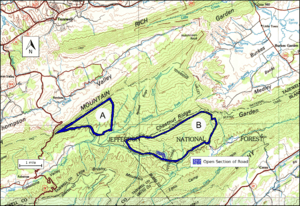
This wild area is in the Appalachian Mountains of Southwest Virginia. It's about 7 miles southeast of Tazewell, Virginia. It sits east of Virginia Route 16 and north of the main Beartown Wilderness.
Hiking the Appalachian Trail
The famous Appalachian Trail runs through this area for 4.7 miles. It goes north from Forest Road 222 to Chestnut Ridge. Then, it follows the ridge along the northeast side of the area.
You can find the Chestnut Knob shelter on the northern side of the trail. This shelter used to be a forest warden's cabin. In 1994, the Forest Service and volunteers turned it into a fully enclosed shelter for hikers. There's also a water supply about 0.2 miles away.
How to get there
You can reach the area by car from different directions.
- From the west, take Virginia Route 16 to Forest Road 222.
- From the north and east, take Virginia Route 42 at Ceres. Then, turn onto Virginia Route 625, which connects to Forest Road 222. Forest Road 222 runs along the southern edge of the area.
Bear Hollow Road (Virginia Route 631) also extends from Forest Road 222 for 1.7 miles. At this point, the road is gated. However, hikers can continue on the Roaring Fork Trail (Forest Trail 6504) for 2.3 miles. This trail crosses into Beartown Wilderness Addition B and then into the Beartown Wilderness.
Old roads and trails
The area has about 10 to 16 miles of old logging roads and informal trails. Some of these are still used by hikers and ATVs, especially during hunting season. You can find these old routes by looking at historical maps from the United States Geological Survey (USGS). The map for this area is called Hutcheson Rock.
The map next to this text shows the boundaries of this wildland. Other maps, like National Geographic Maps 787, show more roads and trails nearby. You can also find lots of information, including maps and satellite views, by clicking on the coordinates at the top right of this page.
Nature and Wildlife
Forests and plants
This area is part of a larger forest region called the Central Appalachian Broadleaf Coniferous Forest-Meadow Province. Most of the trees here are broadleaf trees. You can find trees like yellow poplar, northern red oak, white oak, and maple. These grow in valleys and along small streams. On the north and west sides, you'll see white oak, northern red oak, and hickory trees.
Animals you might see
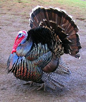
Wild turkeys and black bears are common animals in this area. To help the wildlife, there are two man-made waterholes. Over time, these waterholes are starting to look more natural.
Ancient worm trails
Along the Appalachian Trail, you might spot some interesting fossils called Arthrophycus tracks. They look like long, finger-shaped branches on gray sandstone. These are actually the ancient trails left by worms that lived a very long time ago!
Different types of land
The area has many different types of landscapes. Some parts are hot, dry, and windy ridges. Other parts are cool, moist valleys. Most of the area is covered by a forest type called "Dry Mesic Oak."
There are also about 307 acres of potential old-growth forest. These are very old forests that have not been cut down.
Mountains and Streams
This wildland is part of the Ridge-and-Valley Appalachians. This area has long ridges made of sandstone and shale. Between the ridges are parallel valleys formed from limestone or shale.
Beartown Wilderness Addition B is on the southeastern side of Chestnut Ridge. The lowest point in the area is 2320 feet high, along the southern boundary. The highest point is 4400 feet high, at Chestnut Knob. This area is also where several streams begin, which then flow into Lick Creek and Laurel Creek.
How the Forest Service manages the area
The U.S. Forest Service looks after this land. They have studied their lands to see which ones should be protected as wilderness. Wilderness areas have a high level of protection from development.
Beartown Wilderness Addition B was identified as a "roadless area." This means it's protected from new road construction and timber sales. This helps keep the area wild and natural.
Some private properties near the boundary have special permits. These permits allow them to have waterlines from Laurel Branch and access roads. There are also grassy areas on top of Chestnut Ridge. These areas are mowed by volunteer clubs that help maintain the Appalachian Trail.
In the past, people used vehicles illegally in the area. But law enforcement has largely stopped this.
The National Park Service owns this area as part of the Appalachian Trail. However, the Forest Service manages it. There are also some private companies that own mineral rights (like for mining) on 671 acres within the area.
The Forest Service describes how visitors can enjoy the forest. Much of this area is called "Backcountry Nonmotorized." This means you can hike and explore without motorized vehicles. Some parts are also set aside as "Black Bear Habitat" or "Old Growth with Disturbance."
History of the area
You can still see the remains of an old homesite next to the Appalachian Trail on Chestnut Ridge. There is also a prehistoric site within the area, showing that people lived here long ago.


