Beatrice Willard Alpine Tundra Research Plots facts for kids
Quick facts for kids |
|
|
Willard, Beatrice, Alpine Tundra Research Plots
|
|

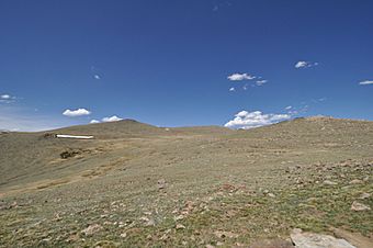
View of the tundra near the Forest Canyon Overlook on the Trail Ridge Road
|
|
| Nearest city | Estes Park, Colorado |
|---|---|
| Area | less than one acre |
| Built | 1959 |
| NRHP reference No. | 07001101 |
| Added to NRHP | October 25, 2007 |
The Beatrice Willard Alpine Tundra Research Plots are special outdoor research areas. They were set up in 1959 in Rocky Mountain National Park, Colorado. These plots are located high up on Trail Ridge Road, above the treeline. This area is known as an alpine tundra habitat.
A scientist named Beatrice Willard used these plots for a long time. She worked for the Institute of Arctic and Alpine Research at the University of Colorado. From 1959 until about 1999, she studied the unique plants and animals of the alpine ecosystem. Her research helped us understand how these high-altitude environments work.
Willard's studies were very important. Her book, Land Above the Trees: A Guide to American Alpine Tundra, taught many people about tundra ecology. The National Park Service even used her advice to help manage the park's high mountain areas. Even after she stopped her main research, Beatrice Willard continued to visit the plots for many years.
Contents
What Are the Research Plots?
There are two main research plots. Each one helps scientists learn about the tundra.
The Rock Cut Plot
The Rock Cut Plot is located very high up, at about 12,110 feet (3,691 meters). It is near the Rock Cut parking area. This research plot is about 5 feet (1.5 meters) wide and 20 feet (6.1 meters) long. It sits inside a larger fenced area, about 50 feet (15.2 meters) by 40 feet (12.2 meters).
A 3-foot (0.9-meter) fence helps protect the plot from park visitors. There is also a sign that explains what the plot is for. An old walking path goes through this plot. Scientists watched this path to see how quickly the tundra plants grew back after being disturbed.
The Forest Canyon Plot
The second plot is called the Forest Canyon Plot. It is a bit lower, at about 11,716 feet (3,571 meters). This plot is smaller, measuring only 10 feet (3 meters) by 10 feet (3 meters). It used to be protected by a metal fence. This plot is close to the Forest Canyon Overlook, a popular viewpoint.
A Historic Research Site
Because of their important scientific history, these plots were added to the National Register of Historic Places. This happened on October 25, 2007. Being on this list means they are recognized as a special place in history.
 | Ernest Everett Just |
 | Mary Jackson |
 | Emmett Chappelle |
 | Marie Maynard Daly |


