
Beaver Dam Mountains facts for kids
Quick facts for kids Beaver Dam Mountains |
|
|---|---|

north section massif
West Mountain Peak (Washington County, UT) |
|
| Highest point | |
| Peak | West Mountain Peak (Washington County) ((northwest)-Beaver Dam Mountains) |
| Elevation | 7,680 ft (2,340 m) |
| Dimensions | |
| Length | 23 mi (37 km) NNW-SSE |
| Width | 13 mi (21 km) |
| Geography | |

Location in Utah
|
|
| Country | United States |
| Communities | Saint George, Utah, Shivwits, Utah and Littlefield, Arizona |
| Range coordinates | 37°05′09″N 113°48′19″W / 37.0858°N 113.8052°W |
| Topo map | Jarvis Peak quad |
The Beaver Dam Mountains are a mountain range in the southwestern United States. They stretch for about 23 miles (37 km). Most of these mountains are in Washington County, Utah. A smaller part of the range goes into the Arizona Strip in Arizona.
These mountains are west of the city of St. George. You can see the southern part of the range very well from Interstate 15. This highway passes through the Virgin River Gorge as it enters Utah. The Virgin River flows out of the western side of the Colorado Plateau here.
What Are the Beaver Dam Mountains Like?
The Beaver Dam Mountains have two main parts. The northern part is a large, solid block of mountains. Its highest point is called West Mountain Peak. This peak is about 7,680 feet (2,341 meters) tall.
On the eastern side of the northern mountains, you'll find Shivwits, Utah. This area is home to the Shivwits Band of Utah. A road called Utah Highway 91 goes through the mountains. It crosses a spot called Utah Hill Summit.
The middle of the mountain range is near Highway 91. Here, you'll find a peak called Tahoari, which is about 5,523 feet (1,683 meters) high.
How Can You Visit the Mountains?
It's easy to get to the middle of the Beaver Dam Mountains. You can reach the Utah Hill Summit, which is about 4,731 feet (1,442 meters) high. Highway 91 connects to it from the southwest, starting from Littlefield, Arizona.
If you are coming from St. George or Interstate 15, you can reach the eastern and southeastern parts of the mountains. There are different roads that lead into these areas.
Images for kids
-
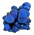
An Azurite mineral from the old Apex mine near Jarvis Peak.

