
Beaverdam Creek Archaeological Site facts for kids

Location in Georgia (U.S. state)
|
|
| Location | Elbert County, Georgia, |
|---|---|
| Region | Elbert County, Georgia |
| Coordinates | 34°4′50.66″N 82°39′50.29″W / 34.0807389°N 82.6639694°W |
| History | |
| Founded | 1200 CE |
| Abandoned | 1500 CE |
| Cultures | South Appalachian Mississippian culture |
| Architecture | |
| Architectural styles | platform mound |
The Beaverdam Creek Archaeological Site (also known as 9 EB 85) is an ancient place where people once lived. It's found in Elbert County, Georgia, near a stream called Beaverdam Creek. This site is now underwater, covered by the Richard B. Russell Lake.
Long ago, this site was home to a Mississippian culture community. They built a special type of earthwork called a platform mound and lived in a village nearby. Experts believe this was the center of a small "chiefdom," which was a group of villages led by a powerful chief.
The main time people lived here and built the mound was between 1200 and 1300 CE. The mound was about 1.5 meters (5 feet) tall and 25 meters (82 feet) wide at its base. The village covered an area of about 15,000 square meters, which is like three football fields! The site was abandoned sometime after 1300 CE.
Contents
Discovering the Past: How Archaeologists Explored the Site
Archaeologists have worked hard to learn about the Beaverdam Creek site. Here's a timeline of their discoveries:
Early Observations and Challenges
- 1969: The site was first officially noticed by Brooks Hutto. He reported that the mound and village had already been damaged by people digging without permission for many years.
- 1971: Joseph R. Caldwell from the University of Georgia led a field school here. However, they faced many problems, including bad weather, more unauthorized digging, and even stolen equipment. This made the excavation difficult.
- 1973: After Caldwell passed away, Chung Ho Lee wrote a report about the 1971 findings. He concluded that the mound was built in several stages during the Savannah period. He also noted that special items, like a copper-covered axe head, were found buried in the mound.
Further Investigations and New Ideas
- 1977: The Institute of Archaeology and Anthropology at the University of South Carolina did more surveys. They found that the village's trash area (called a midden) stretched about 50 meters (164 feet) from the mound.
- 1979: The U.S. Army Corps of Engineers asked the Thunderbird Research Corporation to map the village boundaries more accurately. They did this by digging small test holes and using other methods.
- 1980: Excavations by Gardner and Rappleye found materials from a later period (1375–1475 CE) in the trash area. This suggested the site might have been used for a longer time than first thought. They recommended more digging to the U.S. Army Corps of Engineers.
Major Excavations Before the Lake
- 1980-1981: With funding from the U.S. Army Corps of Engineers and other groups, the University of Georgia led a big excavation. This was done to study the site before it was covered by the new Richard B. Russell Dam and Reservoir. David J. Hally and James C. Rudolph led these efforts. They gathered a lot of information about how the mound was built, what people ate, how their society was organized, and even signs of cooking, tool making, and trash disposal. They also found evidence of one possible village building.
What the Site Tells Us About Ancient Life

The way the mound was built shows how the community's social structure became more complex over time.
How the Mound Grew
The mound started as a simple trash pile. Over time, it grew through several stages:
- First, two square earthlodge buildings were constructed. These were special buildings, possibly for meetings or ceremonies, surrounded by high earthen walls.
- Before the second earthlodge was built, a very important person (known as Burial 2) was buried there.
- Then, a layer of sand, possibly from a flood, covered these structures.
- After this, four more layers were added to create the platform mound. These layers supported other important buildings, likely used for political or religious purposes.
- During one stage, a wide ramp with steps was added to the mound.
Burials and Social Status
Archaeologists found 46 burials at the site, including adults and children. These burials showed that people had different social statuses.
- Burial 2, the important person mentioned earlier, was buried with over 7,000 mussel shell beads and special copper items, like a headpiece and ear spools.
- Finding children buried with special items suggests that some people were born into high status, rather than earning it later in life. This is a sign of a more organized and hierarchical society.
What They Ate: A Diverse Diet
The well-preserved food remains found in the village trash area tell us a lot about what the people ate. They had a very varied diet, using resources from many different places:
- Plants: They grew maize (corn) and squash. They also gathered wild foods like sumpweed, sunflower, maypops, grapes, persimmons, acorns, hickory nuts, grass seeds, and greens.
- Animals: They hunted deer, rabbits, squirrels, raccoons, and turkey. They also fished in the river, catching turtles, catfish, gar, sucker, and bass. This shows they were skilled at using all the natural resources around them.
Understanding Chiefdoms
The discoveries at Beaverdam Creek have helped experts understand more about chiefdoms during the Mississippian period.
- The change from earthlodges to buildings on top of platform mounds, along with the special burials (like Burial 2 and the children with grave goods), shows that the site became a more complex and organized chiefdom.
- The wide variety of plant and animal remains proves that the people had a very diverse way of finding food.
The Site Today
The Beaverdam Creek Archaeological Site (9EB85) is now underwater. The Richard B. Russell Dam was built on the Savannah River, and the reservoir began filling in October 1983, covering the ancient site.
Images for kids
-
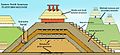
A diagram showing the different layers and parts of a platform mound as it grows over time.
