
Bedford Basin facts for kids

Bedford Basin is a big, sheltered bay located at the northwestern end of Halifax Harbour in Canada. It's on Canada's Atlantic coast. This basin was named after John Russell, 4th Duke of Bedford.
What is Bedford Basin Like?

The basin is entirely within the Halifax Regional Municipality. It stretches about 8 kilometers (5 miles) long and 5 kilometers (3 miles) wide. Low hills surround it, reaching up to 160 meters (525 feet) high. Most hills are between 30 and 60 meters (100–200 feet) tall.
Bedford Basin is quite deep in some spots, going down many dozens of meters. The bottom is muddy, which makes it a great place for ships to anchor safely. Long ago, during the Wisconsin Glaciation (an ice age), the basin and "The Narrows" were part of the Sackville River valley.
The basin has a few smaller areas inside it:
- Bedford Bay, in the far northwest.
- Birch Cove, on the western side.
- Fairview Cove, in the far southwest.
- Wrights Cove, on the eastern side.
The town of Bedford is in the northwest corner and gets its name from the basin. Dartmouth is on the eastern shore. Rockingham covers most of the western shore. Africville Park is on the southern shore, close to the entrance of The Narrows.
A Look at History
From 1759 to 1905, the Royal Navy (Britain's navy) had a base near the basin's entrance. This base was called the Royal Naval Dockyards. Forts like York Redoubt and those on Georges Island and McNabs Island were built to protect the basin. These forts were part of the Halifax Defence Complex. In 1907, Canada took over the dockyards. Today, it is still a naval base called CFB Halifax.
.jpeg)
In December 1917, the basin was the site of a huge explosion. This event is known as the Halifax Explosion. It was the world's worst non-nuclear explosion.
The basin was very important during the First World War and the Second World War. German submarines tried to stop ships carrying supplies across the Atlantic Ocean. Because Port of Halifax was large and close to Europe, Bedford Basin became a meeting point for convoys. A convoy is a group of merchant ships traveling together with naval ships for protection.
The basin was a safe place for these convoys. Defenses were built at The Narrows, the only way into the basin. Torpedo nets were also used to keep German submarines out. This allowed hundreds of ships to gather safely before sailing to Europe.
In 1994, the defenses that protected Bedford Basin were named a National Historic Site of Canada. This honored the important role the basin played in assembling convoys during the World Wars. A special plaque was placed at Admiral Harry DeWolf Park in Bedford. The park is named after Admiral H.G. DeWolf of the Royal Canadian Navy.
Images for kids
-
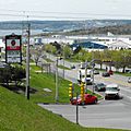
The east side of the basin is home to Burnside Industrial Park. You can see Bedford Bay in the background.

