Belfast Historic District facts for kids
|
Belfast Historic District
|
|

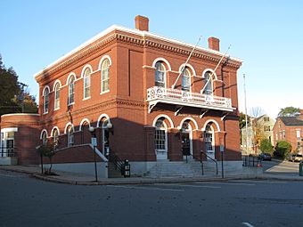
The former Post Office and Custom House building
|
|
| Location | Roughly bounded by High, Grove and Elm, Congress, Main and Market and Imrose, Belfast, Maine |
|---|---|
| Area | 126 acres (51 ha) 2 acres (0.81 ha) (1993 increase) less than one acre (1995 increase) |
| Architect | Calvin Ryder, et al. |
| Architectural style | Greek Revival, Italianate, Federal |
| NRHP reference No. | 86002733 (original) 93000195 (increase 1) 95001476 (increase 2) |
Quick facts for kids Significant dates |
|
| Added to NRHP | August 21, 1986 |
| Boundary increases | April 2, 1993 December 28, 1995 |
The Belfast Historic District is a special area in the city of Belfast, Maine. It's like a time capsule, showing off many old buildings from before the American Civil War (which ended in 1865). You can also see lots of shops and offices built in the late 1800s and early 1900s.
This important district was added to the National Register of Historic Places in 1986. This means it's officially recognized for its historical value. A few small parts were added to the district in 1993 and 1995.
Contents
Exploring Belfast's Past
Where is Belfast?
Belfast is a city located on the west side of Penobscot Bay. It sits right where the Passagassawakeag River flows into the bay. Belfast became a city in 1853.
By then, it was already a very busy place for building ships and sending goods by sea. In the late 1800s, steamboats connected Belfast to other ports. Trains also linked the city to big places like Boston and Portland. Since 1827, Belfast has also been the main government center for Waldo County.
What Makes the District Special?
The downtown area of Belfast has streets that run along the river. The Belfast Historic District covers a big part of this area. It includes many homes built in the first half of the 1800s. It also has many important commercial (business) and government buildings from that time up to the mid-1900s.
Downtown Belfast: A Hub of Activity
The main business area of Belfast is where Main, Church, and Beaver Streets meet. If you walk north on Main Street from this spot, you'll see many beautiful commercial buildings from the late 1800s. This specific area is even listed separately as the Belfast Commercial Historic District.
Important buildings here include the Belfast National Bank and the old Masonic Temple. You'll also find major city buildings like City Hall, the Waldo County Courthouse, and the Customhouse and Post Office. These were all built in the 1850s by famous architects.
Church Street: A Walk Through History
South of the main intersection is Church Street. This street is lined with many high-quality houses. Most of these homes were built between 1840 and 1870. They often show off styles like Greek Revival or Italianate architecture.
One great example is the James P. White House, built in 1842. It's a Greek Revival style home designed by Calvin Ryder. He was a local architect who left a big mark on the city's buildings. At the northern end of Church Street is the First Church of Belfast, built in 1818. It's a lovely example of Federal-period architecture.
Growing the Historic District
After the Belfast Historic District was first listed in 1986, it grew a bit. In 1993, three properties on Anderson Street were added. These had been missed before because of confusion with another historic area called the Primrose Hill Historic District.
Then, in 1996, the Colonial Theater at 121 High Street was added. This theater was built in 1923 in the Colonial Revival style. It was updated in 1947 to the Moderne style. This shows how the city's buildings kept changing and growing over time.
 | William M. Jackson |
 | Juan E. Gilbert |
 | Neil deGrasse Tyson |


