Belltown Run (Muddy Run tributary) facts for kids
Quick facts for kids Belltown Run |
|
|---|---|
| Other name(s) | Tributary to Muddy Run |
| Country | United States |
| State | Delaware |
| County | New Castle |
| Physical characteristics | |
| Main source | Long Creek divide Porter Square, Delaware 72 ft (22 m) 39°25′11″N 075°44′17″W / 39.41972°N 75.73806°W |
| River mouth | Muddy Run Heather Woods, Delaware 19 ft (5.8 m) 39°37′49″N 075°41′51″W / 39.63028°N 75.69750°W |
| Length | 4.49 mi (7.23 km) |
| Basin features | |
| Progression | northeast |
| River system | Christina River |
| Basin size | 6.24 square miles (16.2 km2) |
| Tributaries |
|
| Waterbodies | Becks Pond |
| Bridges | Porter Road, US 40, Salem Church Road |
Belltown Run is a small stream, also called a "run," located in northern New Castle County, Delaware, in the United States. It flows for about 4.49 miles (7.23 km). This stream is an important part of the local water system.
About Belltown Run
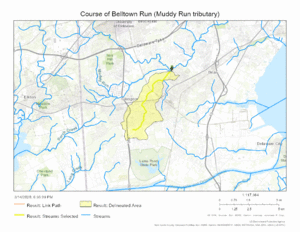
Belltown Run starts in New Castle County, Delaware, near an area called the Long Creek divide. This means it begins where the land separates water flowing in different directions. From there, it travels northeast.
The stream eventually joins another stream called Muddy Run. This meeting point is in a place known as Heather Woods. Belltown Run is a tributary of Muddy Run. A tributary is a smaller stream or river that flows into a larger one.
The Belltown Run Watershed
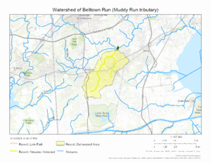
A watershed is like a giant bowl. It is an area of land where all the rain and snowmelt drains into a specific river or stream. The Belltown Run watershed covers about 6.24 square miles (16.2 km²).
This area gets a good amount of rain each year, about 45.2 inches (115 cm). About 18% of the land in this watershed is covered by forests. These forests help keep the water clean. They also provide homes for many plants and animals.
Maps of the Stream
Here are some maps that show where Belltown Run flows and its watershed.
 | Tommie Smith |
 | Simone Manuel |
 | Shani Davis |
 | Simone Biles |
 | Alice Coachman |


