Belmont, Mississippi facts for kids
Quick facts for kids
Belmont, Mississippi
|
|||
|---|---|---|---|

Belmont
|
|||
|
|||

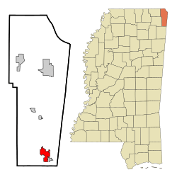
Location of Belmont, Mississippi
|
|||
| Country | United States | ||
| State | Mississippi | ||
| County | Tishomingo | ||
| Area | |||
| • Total | 4.74 sq mi (12.28 km2) | ||
| • Land | 4.73 sq mi (12.25 km2) | ||
| • Water | 0.01 sq mi (0.03 km2) | ||
| Elevation | 581 ft (177 m) | ||
| Population
(2020)
|
|||
| • Total | 1,859 | ||
| • Density | 393.11/sq mi (151.78/km2) | ||
| Time zone | UTC-6 (Central (CST)) | ||
| • Summer (DST) | UTC-5 (CDT) | ||
| ZIP code |
38827
|
||
| Area code(s) | 662 | ||
| FIPS code | 28-05100 | ||
| GNIS feature ID | 2405237 | ||
Belmont is a small town located in Tishomingo County, Mississippi, in the United States. In 2010, about 2,021 people lived there. The most recent count in 2020 showed a population of 1,859.
Contents
History of Belmont
Belmont started as a small settlement called Gum Springs. A post office was built there in 1884. The town grew a lot after the Illinois Central Railroad completed its Birmingham Division in 1907. Belmont officially became a town on January 22, 1908. Its name, "Belmont," means "beautiful mountain."
Geography of Belmont
Belmont is located in southern Tishomingo County. It is just a few miles west of the border between Mississippi and Alabama. The town covers an area of about 4.7 square miles (12.2 square kilometers). Most of this area is land, with a very small part being water.
The main road through Belmont is Mississippi Highway 25. This highway connects Belmont to other towns. Mississippi Highway 366 also crosses MS 25 in Belmont. It goes southeast towards the Alabama state line.
Nearby Communities
Several communities are close to Belmont:
- Golden is about 1.88 miles (3 km) away.
- Red Bay, Alabama, is about 6.20 miles (10 km) away.
- Tishomingo is about 8.86 miles (14 km) away.
- Vina, Alabama is about 12.58 miles (20 km) away.
- Dennis is about 3 miles (5 km) away.
Population Information
Belmont's population has changed over the years. Here's how it has grown and shrunk:
| Historical population | |||
|---|---|---|---|
| Census | Pop. | %± | |
| 1910 | 367 | — | |
| 1920 | 459 | 25.1% | |
| 1930 | 703 | 53.2% | |
| 1940 | 594 | −15.5% | |
| 1950 | 814 | 37.0% | |
| 1960 | 901 | 10.7% | |
| 1970 | 1,237 | 37.3% | |
| 1980 | 1,420 | 14.8% | |
| 1990 | 1,554 | 9.4% | |
| 2000 | 1,961 | 26.2% | |
| 2010 | 2,021 | 3.1% | |
| 2020 | 1,859 | −8.0% | |
| U.S. Decennial Census | |||
2020 Census Details
In 2020, the town of Belmont had 1,859 people living there. There were 862 households and 593 families. The population was made up of different groups:
| Race | Num. | Perc. |
|---|---|---|
| White (non-Hispanic) | 1,578 | 84.88% |
| Black or African American (non-Hispanic) | 10 | 0.54% |
| Native American | 4 | 0.22% |
| Asian | 4 | 0.22% |
| Other/Mixed | 60 | 3.23% |
| Hispanic or Latino | 203 | 10.92% |
Education in Belmont
Belmont offers several educational options for its residents.
Colleges
Students in Belmont can attend Northeast Mississippi Community College. This college is part of the Northeast Mississippi Community College District.
Public Schools
The public schools in Belmont are part of the Tishomingo County School District.
- [Belmont School] serves students from kindergarten through 12th grade. It has about 1,538 students and its sports teams are called the Cardinals.
Private Schools
- Emanuel Christian School is a private school in Belmont. It teaches students from pre-kindergarten through 12th grade. About 52 students attend this school.
Libraries
- The Belmont Public Library is a local library. It is a branch of the Northeast Regional Library system.
Transportation
Getting around Belmont and to other places is possible through its highways and a local airport.
Highways
- Mississippi Highway 25 is a major road that runs north and south. It connects Belmont to Jackson, Mississippi and goes all the way to the Tennessee state line.
- Mississippi Highway 366 travels southeast from Belmont. It reaches the Alabama state line.
Air Travel
- The Tishomingo County Airport is available for air travel needs in the area.
Notable Resident
- Mac McAnally is a famous singer and songwriter. He is from Belmont.
See also
 In Spanish: Belmont (Misisipi) para niños
 | Georgia Louise Harris Brown |
 | Julian Abele |
 | Norma Merrick Sklarek |
 | William Sidney Pittman |


