Bennington, Oklahoma facts for kids
Quick facts for kids
Bennington, Oklahoma
|
|
|---|---|
|
Incorporated Town
|
|

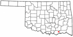
Location of Bennington, Oklahoma
|
|
| Country | United States |
| State | Oklahoma |
| County | Bryan |
| Area | |
| • Total | 0.73 sq mi (1.90 km2) |
| • Land | 0.73 sq mi (1.90 km2) |
| • Water | 0.00 sq mi (0.00 km2) |
| Elevation | 623 ft (190 m) |
| Population
(2020)
|
|
| • Total | 282 |
| • Density | 384.72/sq mi (148.55/km2) |
| Time zone | UTC-6 (Central (CST)) |
| • Summer (DST) | UTC-5 (CDT) |
| ZIP code |
74723
|
| Area code(s) | 580 |
| FIPS code | 40-05400 |
| GNIS feature ID | 2411677 |
Bennington is a small town located in Bryan County, Oklahoma, in the United States. In 2010, about 334 people lived there. By 2020, the population was 282.
Contents
History of Bennington
Early Beginnings: Mission Station
In 1853, a minister named A. G. Lansing started a place called Mount Pleasant Mission Station. It was in the Choctaw Nation, which is now part of Oklahoma. Later, another minister, Rev. Charles C. Copeland, took over. He moved the mission a few miles south because the first spot was wet and unhealthy. Copeland renamed it Bennington Mission Station. He chose this name to honor his hometown of Bennington, Vermont.
Post Office and Growth
A post office opened in Bennington in 1873, but it closed five years later. It reopened in 1884. During these early years, the town was quite small, with only about 45 people living there at its busiest.
Changes in Location and Population
When Bennington was first founded, it was part of Blue County in the Choctaw Nation. Later, in 1886, this area joined with parts of other counties to form Jackson County.
In 1902, a railroad called the Arkansas and Choctaw Railway was built nearby. It passed about two miles away from the original Bennington. Because of this, some of the town's buildings were moved closer to the new railroad line. A new town site was set up in 1903. This new Bennington grew quickly, reaching 250 people in its first year. By 1910, the population had doubled to 513. The town's population reached its highest point in 1920, with 915 people, before it started to decrease.
Geography of Bennington
Bennington is located about 20 miles (32 km) east of Durant. You can find it on County Road E2075. The town covers a total area of about 0.6 square miles (1.6 square kilometers), and all of this area is land.
Population Information
| Historical population | |||
|---|---|---|---|
| Census | Pop. | %± | |
| 1910 | 513 | — | |
| 1920 | 951 | 85.4% | |
| 1930 | 492 | −48.3% | |
| 1940 | 513 | 4.3% | |
| 1950 | 361 | −29.6% | |
| 1960 | 226 | −37.4% | |
| 1970 | 288 | 27.4% | |
| 1980 | 302 | 4.9% | |
| 1990 | 251 | −16.9% | |
| 2000 | 289 | 15.1% | |
| 2010 | 334 | 15.6% | |
| 2020 | 282 | −15.6% | |
| U.S. Decennial Census | |||
The table above shows how Bennington's population has changed over the years. You can see it grew a lot in the early 1900s, then went down, and has stayed relatively small since.
In 2000, there were 289 people living in Bennington. There were 100 households, and 78 of these were families. The town had a mix of people from different backgrounds. About 34% of the population was under 18 years old, showing that many young people lived there. The average age in the town was 30 years.
Famous People from Bennington
- Shockley Shoemake: He was an Oklahoma state legislator and a lawyer.
- Wes Watkins: He served as a United States Representative, meaning he was a member of the U.S. Congress.
See also
 In Spanish: Bennington (Oklahoma) para niños
 | James B. Knighten |
 | Azellia White |
 | Willa Brown |

