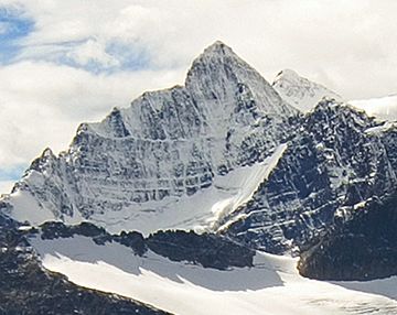
Bennington Peak facts for kids
Quick facts for kids Bennington Peak |
|
|---|---|
 |
|
| Highest point | |
| Elevation | 3,260 m (10,700 ft) |
| Prominence | 150 m (490 ft) |
| Geography | |
| Location | Alberta British Columbia |
| Topo map | NTS 83D/09 |
| Climbing | |
| First ascent | 1926 R.B.M. Bibby, J.H. Hoag, N.W. Spadavecchia |
| Easiest route | East Ridge III 5.4 North Face IV 5.7 |
Bennington Peak is a tall mountain located right on the border between Alberta and British Columbia in Canada. It stands 3,260 meters (about 10,696 feet) high!
The mountain got its name in 1922 from Arthur O. Wheeler. He named it after Bennington, Vermont, which is a town in the United States. This town was the birthplace of a famous explorer named Simon Fraser.
Contents
What's the Weather Like on Bennington Peak?
Bennington Peak has a very cold climate, known as a subarctic climate. This means it has long, snowy winters and short, mild summers.
Winter Weather
In winter, temperatures can drop really low, sometimes below -20 °C (which is -4 °F). With the wind, it can feel even colder, like -30 °C (-22 °F) or less! This is called the wind chill.
Best Time to Visit
If you want to climb Bennington Peak, the best months are usually July and August. The weather is warmer and more pleasant then. However, be prepared for mosquitoes during these months. They can be quite annoying, so bring bug spray!
Where Does the Water Go?
All the rain and melting snow from Bennington Peak flows into two major river systems. On the east side of the mountain, the water drains into smaller streams that eventually join the Athabasca River. On the west side, the water flows into the very beginning parts, or "headwaters," of the Fraser River.
 | Georgia Louise Harris Brown |
 | Julian Abele |
 | Norma Merrick Sklarek |
 | William Sidney Pittman |


