Benton, Arkansas facts for kids
Quick facts for kids
Benton, Arkansas
|
|||
|---|---|---|---|

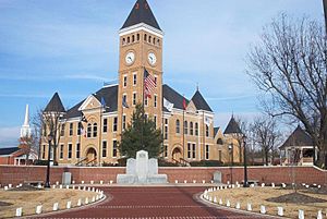
Saline County Courthouse, located in the heart of downtown Benton.
|
|||
|
|||

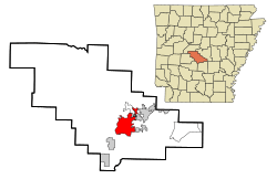
Location in Saline County and the state of Arkansas
|
|||
| Country | |||
| State | |||
| County | Saline | ||
| Government | |||
| • Type | Mayor-Council | ||
| Area | |||
| • Total | 23.42 sq mi (60.65 km2) | ||
| • Land | 22.88 sq mi (59.27 km2) | ||
| • Water | 0.54 sq mi (1.39 km2) | ||
| Elevation | 472 ft (144 m) | ||
| Population
(2020)
|
|||
| • Total | 35,014 | ||
| • Density | 1,530.06/sq mi (590.77/km2) | ||
| Time zone | UTC-6 (Central (CST)) | ||
| • Summer (DST) | UTC-5 (CDT) | ||
| ZIP code |
72015, 72018-19, 72158
|
||
| Area code(s) | 501 | ||
| FIPS code | 05-05290 | ||
| GNIS feature ID | 2403855 | ||
Benton is a city in Saline County, Arkansas, United States. It is the main city, or county seat, of Saline County. Benton is also a suburb of Little Rock.
The city was first settled in 1833. It was named after Missouri Senator Thomas Hart Benton. Benton officially became a city in 1836, when Arkansas became a state.
In 2020, about 35,014 people lived in Benton. This makes it the 12th largest city in Arkansas. Benton is part of the larger Metropolitan Statistical Area.
Contents
City Geography and Climate
Benton covers an area of about 23.42 square miles (60.65 square kilometers). Most of this area is land, with a small part being water.
Benton's Climate Type
The climate in Benton has hot, humid summers. Winters are usually mild to cool. This type of weather is called a humid subtropical climate. It is often shown as "Cfa" on climate maps.
| Climate data for Benton, Arkansas (1991–2020 normals, extremes 1907–1913, 1937–present) | |||||||||||||
|---|---|---|---|---|---|---|---|---|---|---|---|---|---|
| Month | Jan | Feb | Mar | Apr | May | Jun | Jul | Aug | Sep | Oct | Nov | Dec | Year |
| Record high °F (°C) | 83 (28) |
97 (36) |
91 (33) |
95 (35) |
100 (38) |
104 (40) |
112 (44) |
111 (44) |
106 (41) |
98 (37) |
86 (30) |
80 (27) |
112 (44) |
| Mean maximum °F (°C) | 71.2 (21.8) |
74.6 (23.7) |
81.9 (27.7) |
85.8 (29.9) |
90.6 (32.6) |
95.4 (35.2) |
99.4 (37.4) |
99.9 (37.7) |
95.9 (35.5) |
89.3 (31.8) |
79.4 (26.3) |
73.4 (23.0) |
101.3 (38.5) |
| Mean daily maximum °F (°C) | 52.5 (11.4) |
57.1 (13.9) |
65.7 (18.7) |
74.5 (23.6) |
81.6 (27.6) |
89.0 (31.7) |
92.9 (33.8) |
92.6 (33.7) |
86.7 (30.4) |
76.0 (24.4) |
64.1 (17.8) |
54.8 (12.7) |
74.0 (23.3) |
| Daily mean °F (°C) | 41.6 (5.3) |
45.7 (7.6) |
53.6 (12.0) |
62.2 (16.8) |
70.6 (21.4) |
78.8 (26.0) |
82.6 (28.1) |
81.7 (27.6) |
74.8 (23.8) |
63.5 (17.5) |
52.2 (11.2) |
44.0 (6.7) |
62.6 (17.0) |
| Mean daily minimum °F (°C) | 30.6 (−0.8) |
34.3 (1.3) |
41.4 (5.2) |
49.9 (9.9) |
59.6 (15.3) |
68.6 (20.3) |
72.3 (22.4) |
70.8 (21.6) |
62.8 (17.1) |
51.0 (10.6) |
40.3 (4.6) |
33.2 (0.7) |
51.2 (10.7) |
| Mean minimum °F (°C) | 15.9 (−8.9) |
20.1 (−6.6) |
24.8 (−4.0) |
35.3 (1.8) |
44.5 (6.9) |
57.9 (14.4) |
63.7 (17.6) |
61.4 (16.3) |
48.9 (9.4) |
35.1 (1.7) |
24.7 (−4.1) |
19.6 (−6.9) |
12.6 (−10.8) |
| Record low °F (°C) | −12 (−24) |
−17 (−27) |
6 (−14) |
23 (−5) |
31 (−1) |
44 (7) |
50 (10) |
46 (8) |
31 (−1) |
20 (−7) |
7 (−14) |
−2 (−19) |
−17 (−27) |
| Average precipitation inches (mm) | 3.84 (98) |
4.20 (107) |
5.05 (128) |
5.63 (143) |
5.22 (133) |
3.94 (100) |
4.16 (106) |
3.52 (89) |
3.80 (97) |
4.37 (111) |
4.77 (121) |
4.91 (125) |
53.41 (1,357) |
| Average snowfall inches (cm) | 0.6 (1.5) |
0.4 (1.0) |
0.3 (0.76) |
0.0 (0.0) |
0.0 (0.0) |
0.0 (0.0) |
0.0 (0.0) |
0.0 (0.0) |
0.0 (0.0) |
0.0 (0.0) |
0.0 (0.0) |
0.0 (0.0) |
1.3 (3.3) |
| Average precipitation days (≥ 0.01 in) | 6.2 | 6.1 | 7.0 | 7.6 | 7.7 | 5.3 | 6.0 | 5.0 | 4.8 | 5.9 | 6.2 | 6.4 | 74.2 |
| Average snowy days (≥ 0.1 in) | 0.2 | 0.2 | 0.1 | 0.0 | 0.0 | 0.0 | 0.0 | 0.0 | 0.0 | 0.0 | 0.0 | 0.0 | 0.5 |
| Source: NOAA | |||||||||||||
Benton's Population History
Benton has grown a lot over the years. In 1880, only 452 people lived there. By 2020, the population had grown to 35,014. This shows how much the city has developed.
| Historical population | |||
|---|---|---|---|
| Census | Pop. | %± | |
| 1880 | 452 | — | |
| 1890 | 647 | 43.1% | |
| 1900 | 1,025 | 58.4% | |
| 1910 | 1,708 | 66.6% | |
| 1920 | 2,933 | 71.7% | |
| 1930 | 3,445 | 17.5% | |
| 1940 | 3,502 | 1.7% | |
| 1950 | 6,277 | 79.2% | |
| 1960 | 10,399 | 65.7% | |
| 1970 | 16,499 | 58.7% | |
| 1980 | 17,717 | 7.4% | |
| 1990 | 18,177 | 2.6% | |
| 2000 | 21,906 | 20.5% | |
| 2010 | 30,681 | 40.1% | |
| 2020 | 35,014 | 14.1% | |
| U.S. Decennial Census | |||
Who Lives in Benton?
In 2020, there were 35,014 people living in Benton. Most residents, about 77.56%, were White (non-Hispanic). About 9.83% were Black or African American. Other groups included Asian (1.39%), Native American (0.45%), and Pacific Islander (0.03%). About 5.8% of the population was Hispanic or Latino.
Education in Benton
Students in Benton attend public schools. These schools are part of different school districts.
- The main school district is the Benton School District. Students from this district usually graduate from Benton High School.
- Some students attend schools in the Bryant Public Schools district. They go to Bryant High School.
- The Bauxite School District also serves a part of the city.
- A small area of Benton is served by the Harmony Grove School District. This district operates Benton Harmony Grove High School.
Famous People from Benton
Many interesting people have connections to Benton. Here are a few:
- Ann Clemmer – A former member of the Arkansas House of Representatives. She was part of the Republican Party.
- Lanny Fite – He took Ann Clemmer's place in the state House. He was also a former county judge for Saline County.
- Wes Gardner – A former baseball player. He was a relief pitcher for teams like the New York Mets and Boston Red Sox.
- Stuart Greer – An actor who has appeared in movies and on TV. He lives in Benton part-time.
- Kim Hammer – Another Republican member of the Arkansas House of Representatives.
- Kenneth Henderson – A Republican member of the Arkansas House for Pope County. He used to live in Benton.
- Cliff Lee – A famous baseball player. He won the Cy Young Award in 2008 while playing for the Cleveland Indians.
- Justin Moore – A popular country music artist. He lives in Benton.
- Joe Purcell – He served as the governor of Arkansas for a short time in 1979. He was also a Democratic lieutenant governor and attorney general.
- Charlie Rich – A country music artist who won many Grammy Awards.
See also
 In Spanish: Benton (Arkansas) para niños
 | Jackie Robinson |
 | Jack Johnson |
 | Althea Gibson |
 | Arthur Ashe |
 | Muhammad Ali |


