Berango facts for kids
Quick facts for kids
Berango
|
|||
|---|---|---|---|
 |
|||
|
|||
| Country | Spain | ||
| Autonomous community | Basque Country | ||
| Province | Biscay | ||
| Comarca | Greater Bilbao | ||
| Area | |||
| • Total | 8.9 km2 (3.4 sq mi) | ||
| Elevation | 31 m (102 ft) | ||
| Population
(2018)
|
|||
| • Total | 7,130 | ||
| • Density | 801/km2 (2,075/sq mi) | ||
| Demonym(s) | Basque: berangotarra | ||
| Time zone | UTC+1 (CET) | ||
| • Summer (DST) | UTC+2 (CEST) | ||
| Postal code |
48640
|
||
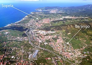
Berango is a town and municipality in Spain. It is located in the province of Biscay, which is part of the Basque Country. Berango is also part of a larger area called "Greater Bilbao."
The town covers about 8.9 km² (square kilometers). In 2019, about 7,195 people lived there. This means the population density was about 174.81 people per square kilometer.
Where is Berango Located?
Berango is surrounded by several other towns. To the north, it borders Sopelana. To the northeast, it is next to Urduliz. In the southeast, you'll find Erandio, and to the west, it borders Getxo.
Mountains and Rivers
The area around Berango has some hills and mountains. These include Munarrikolanda, Saiherri, and Agirremendi.
The Gobela river flows through Berango. This river eventually empties into the Bahía de El Abra, which is a bay. Berango also gets water from Larrañazubi's streams and several natural springs.
Who Leads Berango?
The leader of Berango is called the Mayor. The current Mayor is María Isabel Landa Gaubeka. She is a member of the Basque Nationalist Party.
See Also

- You can find more information about Berango for kids in Spanish here: Berango para niños
 | Isaac Myers |
 | D. Hamilton Jackson |
 | A. Philip Randolph |


