Bermagui River facts for kids
Quick facts for kids Bermagui River |
|
|---|---|

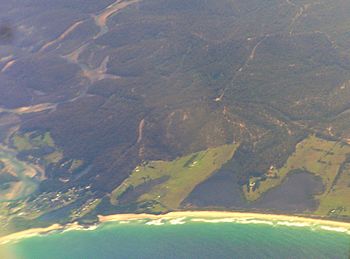
An aerial view of the mouth of the Bermagui River, pictured bottom left, 2011.
|
|
| Native name | Permageua |
| Other name(s) | Bermaguee |
| Country | Australia |
| State | New South Wales |
| Region | South East Corner (IBRA), South Coast |
| Local government area | Bega Valley |
| Town | Bermagui |
| Physical characteristics | |
| Main source | Coolagolite Creek and Nutleys Creek Bermagui South 26 m (85 ft) |
| River mouth | Tasman Sea, South Pacific Ocean near Bermagui |
| Length | 7 km (4.3 mi) |
| Depth |
|
| Basin features | |
| Basin size | 296 km2 (114 sq mi) |
The Bermagui River is a beautiful river located on the South Coast of New South Wales, Australia. It is a type of river called a "barrier estuary." This means it's a place where the river meets the sea, and a sandbar or barrier often separates it from the open ocean. It's a key part of the local environment near the town of Bermagui.
Contents
Exploring the Bermagui River
The Bermagui River starts when two smaller streams, Coolagolite Creek and Nutleys Creek, join together. This joining point is called a confluence. It happens near a place called Bermagui South.
River's Journey to the Sea
From its start, the Bermagui River flows generally towards the east. After a journey of about 7 km (4.3 mi), it reaches its mouth. Here, the river's fresh water mixes with the salty water of the Tasman Sea, which is part of the huge South Pacific Ocean. The river drops about 26 m (85 ft) in height from its source to its mouth.
Understanding the River's Size
The area of land that collects water for the Bermagui River is called its catchment area. This area is about 83 km2 (32 sq mi). The river itself holds a large amount of water, about 2,160 ML (1,750 acre⋅ft), and covers a surface area of 2.2 km2 (0.85 sq mi). On average, the river is about 1.1 m (3.6 ft) deep.
What Does "Bermagui" Mean?
The name "Bermagui" comes from the Aboriginal Dyirringanj language. The original words were spelled like permageua or bermaguee. These words mean "a canoe with paddles." This shows the historical importance of canoes and the river to the local Aboriginal people.
 | John T. Biggers |
 | Thomas Blackshear |
 | Mark Bradford |
 | Beverly Buchanan |

