Bessemer (Pueblo) facts for kids
Quick facts for kids
Bessemer
|
|
|---|---|
|
Neighborhood and former city
|
|
| Country | United States |
| State | Colorado |
| County | Pueblo |
| Municipality | Pueblo |
| Founded | 1880 |
| Incorporated | July 15, 1886 |
| Consolidated | March 21, 1894 |
Bessemer, Colorado was once a separate city in Colorado. It was officially formed in 1886. The city got its name from Henry Bessemer, a clever inventor from England.
Bessemer was one of four towns that grew quickly after the Colorado Gold Rush of 1859. These towns, including Bessemer, South Pueblo, Central Pueblo, and Pueblo, later joined together. They formed the larger city we know today as Pueblo, Colorado. Bessemer was the last city to join, becoming part of Pueblo in 1894.
Today, the area that was once Bessemer is known as the Bessemer neighborhood. You might also hear it called the Bessemer area. This area is home to Bessemer Academy, an elementary school, and Ray Aguilera Park. The park was formerly known as Bessemer Park and Minnequa Park.
Where is Bessemer Located?
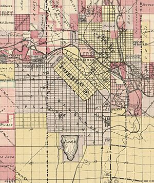
The original map for Bessemer was officially recorded on August 20, 1886. This map was filed with the Pueblo County Clerk. The town was bordered by the steel mill to the east. To the west were Prairie and Western avenues, which are now called Pueblo Boulevard. Aqua Avenue and what is now Lake Minnequa formed the southern border. To the north, it was bordered by South Pueblo and River Road.
Today, the area people call "Greater Bessemer" is a bit larger. It's generally located north of the Mesa Junction neighborhood. Russ Avenue and the steel mill are to the east. Reno Avenue is to the south, and Berkley Avenue is to the west. This larger area includes Lake Minnequa and Minnequa Heights.
Another study, the Bessemer Historic Study, describes Bessemer as the area between Washington Street to the north and Berkley Avenue to the west. Interstate 25 is to the east, and Streator Avenue is to the south. This study also includes Lake Minnequa and the area around the old Edison School. Parts of Minnequa Heights are also part of this study area.
The Bessemer area is mostly flat. There's a small rise in elevation towards the southern part of the neighborhood. A natural dip in the land was turned into a man-made lake, which is now Lake Minnequa. The Laibach Subdivision is located on a small hill that looks over the Grove neighborhood.
A Look Back: Bessemer's History
In February 1880, workers from the Colorado Coal and Iron Company (CC&I) started surveying land. They were planning to build their first factory, the South Pueblo Ironworks. This factory grew very quickly. It produced 284 tons of pig iron in its first year and 6,392 tons the next.
Instead of traveling far to work, many workers began to live near the plant. As more workers arrived, more simple homes were built. By 1882, CC&I had planned out the town of Bessemer. However, the official map wasn't filed until 1886. The 1886 map showed a much larger Bessemer, even surrounding South Pueblo. In 1886, about 188 people were listed as living in Bessemer. In 1887, CC&I filed a new map that made Bessemer smaller, back to its original planned size from 1882.
In 1892, CC&I joined with the Colorado Fuel Company. Together, they formed the Colorado Fuel and Iron Company (CF&I). The company and the town faced challenges during the Panic of 1893, a time of economic trouble. Because of this, no new neighborhoods were built in Bessemer between 1892 and 1899.
In January 1894, the people of Bessemer asked their city leaders and Pueblo's leaders to join the two cities. The Pueblo City Council agreed and called for a special election on March 18, 1894. Pueblo voters approved the idea with 537 votes for and 200 against. Bessemer residents also approved it with 212 votes for and 176 against. The joining of the cities became official on March 21, 1894.
The Bessemer Indicator, a local newspaper, started publishing in 1890. In January 1905, the newspaper reported that Bessemer's population had grown a lot. It went from 4,000 people in 1894 to 15,000 people in 1905.
Bessemer's first city hall was built by CC&I. It was located at the corner of Charles Street (now Abriendo Avenue) and Central Avenue. The second city hall was built in 1890 at 1207 East Evans Avenue. However, this building was taken down between 1939 and 1940.
Bessemer's growth slowed down in the 1920s and 1930s. This was when CF&I's profits were low. By the 1960s, the neighborhood started to decline. Not many new buildings were constructed after 1960 because of CF&I's financial problems. Only 112 new buildings were put up between 1961 and 2010. The decline of the US steel industry in the 1980s hit the neighborhood very hard.
 | Dorothy Vaughan |
 | Charles Henry Turner |
 | Hildrus Poindexter |
 | Henry Cecil McBay |


