Bethulie facts for kids
Quick facts for kids
Bethulie
|
|
|---|---|

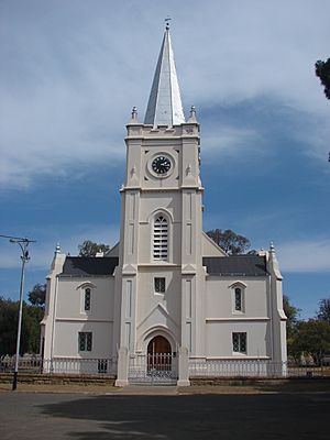
Nederduitse Gereformeerde Church, Grey Street, Bethulie
|
|
| Country | South Africa |
| Province | Free State |
| District | Xhariep |
| Municipality | Kopanong |
| Established | 1863 |
| Government | |
| • Type | Municipality |
| Area | |
| • Total | 37.0 km2 (14.3 sq mi) |
| Population
(2023)
|
|
| • Total | +-16,000 |
| • Density | −430/km2 (−1,100/sq mi) |
| Racial makeup (2011) | |
| • Black African | 81.6% |
| • Coloured | 9.3% |
| • Indian/Asian | 0.7% |
| • White | 8.0% |
| • Other | 0.4% |
| First languages (2011) | |
| • Xhosa | 43.8% |
| • Sotho | 31.0% |
| • Afrikaans | 18.9% |
| • English | 2.7% |
| • Other | 3.7% |
| Time zone | UTC+2 (SAST) |
| Postal code (street) |
9992
|
| PO box |
9992
|
| Area code | 051 |
Bethulie is a small town in the Free State province of South Africa. It is known for its sheep and cattle farms. The name "Bethulie" means chosen by God. This name was given by people from a mission station in 1829, which is where the town grew from. The mission building is the oldest building built by settlers that is still standing in the Free State. Bethulie was also home to one of the largest camps set up by the British during the Boer War. The Dutch Reformed Church in town was built in 1862.
Contents
History of Bethulie
Evidence of very old life has been found near Bethulie. Fossils show that creatures lived here about 250 million years ago!
The first people to live in the Bethulie area were the Bushmen. You can still see their amazing drawings in the region today.
Early Settlements and Missionaries
In 1828, a mission station was started by the London Missionary Society. It was for the local San Bushman people. The area was first called Groot Moordenaarspoort, which means "Murderer's Pass." This name came from a big fight between the Sotho and Griqua tribes.
In 1832, a missionary named Jean Pierre Pellissier took over. His old home is one of the oldest pioneer buildings north of the Orange River. Today, it is a museum. It shows items from the past and tells the story of Jean Pellissier and Chief Lephoi.
How Bethulie Got Its Name
Until 1833, Bethulie was known as Caledon. This name was confusing because there was another town called Caledon in the Western Cape. In 1833, a French Missionary Society called the "Paris Evangelical Missionary Society" took charge. They renamed the mission station Bethulua, which means "Place of Worship." Later, in 1835, it was called Verheullpolis. In 1863, the town was officially started and named Heidelberg. Finally, in 1872, the town was renamed Bethulie, which is what it is called today.
Bethulie During the Boer War
During the Anglo-Boer War (from 1899 to 1902), the British set up a very large camp in Bethulie. It was the third-largest camp of its kind. Many people, including women and children, were kept there during the war.
Important Dates in Bethulie's Past
- 1777: R.J. Gordon reached the Groot River, which is about 10 kilometers from Bethulie. He named it the Oranje River. He also drew pictures of the area and noted seeing six Bushmen.
- 1803: Governor J.W. Janssens visited the area where Bethulie is now.
- 1809: Colonel R. Collins reached where the Caledon and Oranje rivers meet. He is given credit for naming the Caledon River.
- 1823: G.P.N. Coetsee traveled in the area and only saw Bushmen, with no other groups of people.
- 1828-1833: Missionaries J. Clark and G.A. Kolbe worked with the Bushman community.
- 1833-1867: Missionary J.P. Pellissier worked with the Tihaping community.
- 1860-1863: Farmers bought 6,000 morgen of land from the Tlhaping people. (A morgen was an old unit for measuring land). This land was then officially made into a town called Heidelberg.
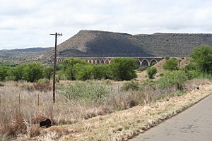
The D.H. Steyn Bridge, also known as the Hennie Steyn Bridge, is an amazing arched bridge near Bethulie. It is a special bridge that carries both roads and trains across the Orange River. It is 1,152 meters (about 1,260 yards) long and 51.5 meters high. This makes it the longest bridge in South Africa! Some even say it's the longest in the southern part of the world. Work on the bridge started in 1899 and was finished in 1901.
Famous People from Bethulie
Bethulie's most famous person was Patrick Mynhardt. He was an actor known for his one-man shows. In these shows, he played a character called Oom Schalk Lourens, created by Herman Charles Bosman. Patrick Mynhardt also wrote a book about his life, called Boy from Bethulie.
 | Precious Adams |
 | Lauren Anderson |
 | Janet Collins |


