Beuningen, Gelderland facts for kids
Quick facts for kids
Beuningen
|
|||
|---|---|---|---|

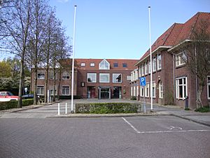
Beuningen town hall
|
|||
|
|||

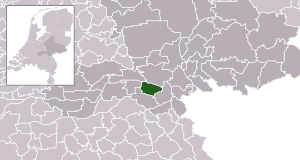
Location in Gelderland
|
|||
| Country | Netherlands | ||
| Province | Gelderland | ||
| Government | |||
| • Body | Municipal council | ||
| Area | |||
| • Total | 47.09 km2 (18.18 sq mi) | ||
| • Land | 43.70 km2 (16.87 sq mi) | ||
| • Water | 3.39 km2 (1.31 sq mi) | ||
| Elevation | 9 m (30 ft) | ||
| Population
(May 2014)
|
|||
| • Total | 25,267 | ||
| • Density | 578/km2 (1,500/sq mi) | ||
| Demonym(s) | Beuninger | ||
| Time zone | UTC+1 (CET) | ||
| • Summer (DST) | UTC+2 (CEST) | ||
| Postcode |
6550–6551, 6640–6645
|
||
| Area code | 024, 0487 | ||
Beuningen is a municipality and a town located in the eastern part of the Netherlands. It is a place where people live and work together. Beuningen is quite close to the larger city of Nijmegen.
Contents
What is Beuningen?
Beuningen is known as a municipality. Think of a municipality like a local government area. It includes the main town of Beuningen itself, plus a few other nearby towns. These towns work together under one local government.
Where is Beuningen Located?
Beuningen is in the Gelderland province of the Netherlands. It's in the eastern part of the country. A big river called the Waal flows about 1.5 kilometers (about 1 mile) north of Beuningen. This river is a branch of the Rhine river.
What Can You Find in Beuningen?
Beuningen is a lovely place with some interesting features. One special thing you can find there is a restored windmill. This windmill is called De Haag. Windmills are important historical structures in the Netherlands. They were used for many things, like grinding grain or pumping water.
Towns in the Beuningen Municipality
Besides the main town of Beuningen, the municipality also includes three other towns. These are Ewijk, Weurt, and Winssen. Each of these towns has its own unique character and history. They all contribute to the community of Beuningen.
Images for kids
 | William Lucy |
 | Charles Hayes |
 | Cleveland Robinson |


