
Bilafond La facts for kids
Bilafond La, which means "Pass of the Butterflies," is a special pathway through the tall mountains. It's also known as the Saltoro Pass. This pass is located high up in the Himalayas, on a mountain range called the Saltoro Ridge. It sits to the west of the huge Siachen Glacier, which is one of the longest glaciers in the Karakoram mountain range. Today, India controls this important mountain pass. It is very close to the Line of Control, which is a boundary line that separates areas managed by India and Pakistan.
Contents
What is Bilafond La?
Bilafond La is a mountain pass, which is like a natural doorway or path through a mountain range. Imagine a low spot between two high peaks – that's often where a pass is found. These passes are important because they allow people to travel from one side of a mountain range to another, even in very difficult terrain. Bilafond La is located in a very high and cold part of the Himalayas, making it a challenging but significant location.
Location in the Himalayas
The pass is part of the Saltoro Ridge, which is a sub-range of the mighty Karakoram mountains. The Karakoram range is known for having some of the world's highest peaks. Bilafond La is situated in a region called Ladakh, which is in the northern part of India. This area is famous for its stunning, rugged landscapes and extreme weather conditions, especially at high altitudes.
Near the Siachen Glacier
Bilafond La is located just west of the Siachen Glacier. The Siachen Glacier is a massive river of ice, one of the longest in the Karakoram. It's also one of the highest battlefields in the world, known for its extremely cold temperatures and harsh conditions. The pass's closeness to this glacier makes it a strategically important point.
Who Controls Bilafond La?
Currently, Bilafond La is controlled by India. The control of this pass is part of a larger situation involving the border areas between India and Pakistan. Both countries have a history of disagreements over certain territories in the region.
The Line of Control
The Line of Control (LoC) is a military boundary line that divides the parts of Kashmir controlled by India and Pakistan. It's not an internationally recognized border, but it serves as a de facto (in practice) boundary. Bilafond La is very close to this line, which highlights its importance in the region's geography and security.
Images for kids
-
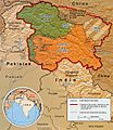
Indo-Pak mutually-agreed undisputed "International Border" (IB) in black line, Indo-Pak "Line of Control" (LoC) in black dotted line in the north and west, Indo-Sino "Line of Actual" (LAC) in black dotted line in the east, Indo-Pak line across Siachen in north is "Actual Ground Position Line" (AGPL). The areas shown in green are the two Pakistani-controlled areas: Gilgit–Baltistan in the north and Azad Kashmir in the south. The area shown in orange is the Indian-controlled territories of Jammu and Kashmir, and Ladakh, and the diagonally-hatched area to the east is the Chinese-controlled area known as Aksai Chin. "Territories ceded by Pakistan to China claimed by India" in the north is Shaksgam (Trans-Karakoram Tract).
-
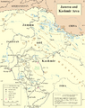
United Nations map of Siachen Glacier showing "Point NJ980420" (Point NJ9842) as starting point of "Actual Ground Position Line" (AGPL), Goma military camp of Pakistan, Nubra River valley and Siachen glaciers held by India; Bilafond La and Sia La north of NJ9842 are also held by India. Masherbrum Range, Baltoro Glacier, Baltoro Glacier, Baltoro Muztagh and K2 are held by Pakistan.


