
Binalong Bay facts for kids
Quick facts for kids Binalong BayTasmania |
|||||||||||||||
|---|---|---|---|---|---|---|---|---|---|---|---|---|---|---|---|

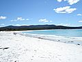
Binalong Bay Beach
|
|||||||||||||||

Binalong Bay
Location in Tasmania
|
|||||||||||||||
| Population | 290 (2016 census) | ||||||||||||||
| Postcode(s) | 7216 | ||||||||||||||
| Location | 12 km (7 mi) NE of St Helens | ||||||||||||||
| LGA(s) | Break O'Day Council | ||||||||||||||
| Region | North-east | ||||||||||||||
| State electorate(s) | Lyons | ||||||||||||||
| Federal Division(s) | Lyons | ||||||||||||||
|
|||||||||||||||
Binalong Bay is a small coastal town in the Australian state of Tasmania. It is located in the Break O'Day area, which is in the northeast part of Tasmania. This lovely spot is about 12 kilometers (7.5 miles) northeast of the town of St Helens.
Binalong Bay is famous for being at the southern end of the beautiful Bay of Fires. It used to be a small village where people mostly fished. Today, it's a popular place for holidays, with many houses used by visitors. The town has a nice beach, a small harbor called the gulch, and a cafe. In 2016, about 290 people lived in Binalong Bay.
Contents
History of Binalong Bay
Binalong Bay became an official place on maps in 1964. Before that, it was known as Boat Harbour. The name Binalong Bay was chosen in 1944. Many people believe this name comes from an Aboriginal word. The town even had its own Post Office for a few years, from 1966 to 1973.
Exploring Binalong Bay's Geography
Binalong Bay is right on the coast. The beautiful waters of the Bay of Fires are to its east. These waters are part of the Tasman Sea. Georges Bay also forms part of the southern and eastern edges of the area. There is also a lagoon nearby called Grants Lagoon. It is an inlet of Binalong Bay's main body of water.
Getting Around Binalong Bay
The main road into Binalong Bay is Route C850, also known as Binalong Bay Road. It comes from the southwest and goes through the town to the east. Other roads help people get around the area. Route C848, called Gardens Road, starts from C850 and goes north. Route C849, known as Reids Road, starts from C848 and heads west.
Images for kids
-
Binalong Bay Beach
-
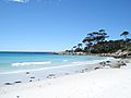
Beach and rocks


