
Binic facts for kids
Quick facts for kids
Binic
Binig
|
|||
|---|---|---|---|
|
Part of Binic-Étables-sur-Mer
|
|||

Main quay
|
|||
|
|||

Binic
Location in France

Binic
Location in Brittany
|
|||
| Country | France | ||
| Region | Brittany | ||
| Department | Côtes-d'Armor | ||
| Arrondissement | Saint-Brieuc | ||
| Canton | Plouha | ||
| Commune | Binic-Étables-sur-Mer | ||
| Area
1
|
5.96 km2 (2.30 sq mi) | ||
| Population
(2019)
|
3,787 | ||
| • Density | 635.4/km2 (1,645.7/sq mi) | ||
| Time zone | UTC+01:00 (CET) | ||
| • Summer (DST) | UTC+02:00 (CEST) | ||
| Postal code |
22520
|
||
| Elevation | 0–86 m (0–282 ft) | ||
| 1 French Land Register data, which excludes lakes, ponds, glaciers > 1 km2 (0.386 sq mi or 247 acres) and river estuaries. | |||

.svg)

Binic (pronounced "bee-neek") is a charming former fishing port in Brittany, France. It's located about 12 kilometers (7.5 miles) north of Saint-Brieuc on the coast of the Côtes-d'Armor area.
Binic used to be its own town. However, on March 1, 2016, it joined with another town, Étables-sur-Mer. Now they are one bigger town called Binic-Étables-sur-Mer.
The name "Binic" comes from an old Breton word. Pen means "head" or "end," and the -ic part refers to the Ic river. This river flows through the village and into the English Channel. So, Binic means "the mouth of the river Ic."
People also call Binic by fun nicknames. It's known as the City of Spray because of the ocean. More recently, it's been called The Beauty Spot of the Cotes d'Armor.
Contents
Binic's Story: A Look Back in Time
The history of Binic goes back a very long way. People lived here during the Neolithic period. This was between 3500 and 1800 BC, when early humans started farming.
You can still find large stone monuments from this time. These are called megaliths. One famous one was the dolmen of Margot's Table. A dolmen is a type of ancient stone tomb. Sadly, this one was destroyed in 1816 when the port was being built.
Binic in the Middle Ages
During the Middle Ages, Binic was a tiny village. It had fewer than twenty houses. Even so, it was a popular place for markets and fairs. People from nearby villages would come to trade and meet.
Becoming a Town
In 1821, Binic officially became a town. This happened thanks to a lot of hard work. A ship owner named François Le Saulnier de Saint Jouan pushed for it. He had help from the Duchess of Angoulême. She was the daughter of King Louis XVI. At this time, Binic had 1,611 people living there. The exact borders of Binic were decided later, in 1840.
A Busy Fishing Port
The 1800s were a great time for Binic. By 1845, it was France's most important port for deep sea fishing. About 150 to 160 ships came to the port each year. They fished for cod in Newfoundland (island). They also traded goods along the coast. These goods included salt, wine, wood, flour, and vegetables. Binic was the top port for cod fishing back then.
Changes in the 20th Century
The early 1900s brought big changes. In 1904, France signed an agreement called the Entente Cordiale. This agreement meant France gave up its claims to Newfoundland. This ended Binic's busy fishing days there. Also, too much fishing led to a collapse of the fish stocks in 1992.
World War I also caused problems. German submarines were a threat. Fishing costs went up, and rules became stricter. New steam-powered fishing boats also created more competition. Many ports in the area struggled for about 30 years.
New Beginnings
Eventually, new fishing methods helped Binic recover. The area around Saint-Brieuc Bay became known for scallop fishing. Binic joined in this new industry. By 1992, Binic's fishing boats started unloading their scallops in the nearby port of Saint-Quay-Portrieux. Binic's own port then became a place for yachts and pleasure boats.
The Railway Era
From 1906 to 1956, Binic had a railway station. It was part of the local railway system. The railway left behind some important structures. You can still see two railway bridges. One is called the Chien Noir (Black Dog) or La Hasée viaduct. The other is the Beaufeuillage viaduct. A viaduct is a long bridge-like structure that carries a road or railway.
Joining Forces
On March 1, 2016, Binic officially merged with Étables-sur-Mer. They became one new commune called Binic-Étables-sur-Mer.
Population of Binic
People who live in Binic are called Binicais in French. Here's how the population has changed over the years:
| Historical population | |||||||||||||||||||||||||||||||||||||||||||||||||||||||||||||||||||||||||||||||||||||||||||||||||
|---|---|---|---|---|---|---|---|---|---|---|---|---|---|---|---|---|---|---|---|---|---|---|---|---|---|---|---|---|---|---|---|---|---|---|---|---|---|---|---|---|---|---|---|---|---|---|---|---|---|---|---|---|---|---|---|---|---|---|---|---|---|---|---|---|---|---|---|---|---|---|---|---|---|---|---|---|---|---|---|---|---|---|---|---|---|---|---|---|---|---|---|---|---|---|---|---|---|
|
|
||||||||||||||||||||||||||||||||||||||||||||||||||||||||||||||||||||||||||||||||||||||||||||||||
Images for kids
-

The Binic Lighthouse (Panorama view)
-
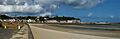
The seashore at low tide
See also
 In Spanish: Binic para niños
