Bitter Springs, Arizona facts for kids
Quick facts for kids
Bitter Springs, Arizona
|
|
|---|---|

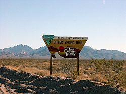
The Bitterspring trail, located off a Bureau of Land Management Back Country Byway in Coconino County
|
|

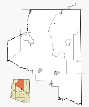
Location in Coconino County and the state of Arizona
|
|
| Country | United States |
| State | Arizona |
| County | Coconino |
| Area | |
| • Total | 8.02 sq mi (20.77 km2) |
| • Land | 8.02 sq mi (20.77 km2) |
| • Water | 0.00 sq mi (0.00 km2) |
| Elevation | 5,604 ft (1,708 m) |
| Population
(2020)
|
|
| • Total | 355 |
| • Density | 44.26/sq mi (17.09/km2) |
| Time zone | UTC-7 (MST) |
| • Summer (DST) | UTC-6 (MDT) |
| FIPS code | 04-06470 |
| GNIS feature ID | 2407852 |
Bitter Springs (which is called Díchʼíító in the Navajo language) is a small village in Coconino County, Arizona, United States. It is part of the Navajo Nation. In 2020, about 364 people lived there.
Where is Bitter Springs?
Bitter Springs is located in Arizona. It covers an area of about 20.8 square kilometers (8.0 square miles). All of this area is land.
Bitter Springs is also where U.S. Route 89A ends. This road was changed when the Glen Canyon Dam was built.
People and Language
Bitter Springs was first counted as a special place for the census in 2000.
| Historical population | |||
|---|---|---|---|
| Census | Pop. | %± | |
| 2000 | 547 | — | |
| 2010 | 452 | −17.4% | |
| 2020 | 355 | −21.5% | |
| U.S. Decennial Census | |||
In 2000, there were 547 people living in Bitter Springs. Most of the people living there were Native American.
Many people in Bitter Springs speak the Navajo language. In 2000, about 73% of homes spoke Navajo. About 27% of homes spoke English.
Education
Students in Bitter Springs go to schools run by the Page Unified School District. These schools are located in a nearby town called Page, Arizona.
See also
 In Spanish: Bitter Springs (Arizona) para niños
 | Jewel Prestage |
 | Ella Baker |
 | Fannie Lou Hamer |


