Black Falls, Arizona facts for kids
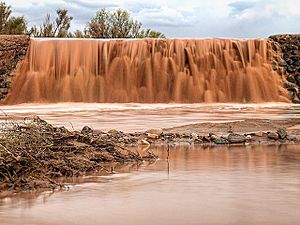
Black Falls is a cool natural rock dam made of basalt. It's an important spot to cross the Little Colorado River in Coconino County, Arizona. You can find it close to the Wupatki National Monument. A small community of the Navajo Nation nearby is also called Black Falls, named after this crossing.
Contents
How Black Falls Was Formed
About 20,000 years ago, hot lava flowed from a volcano called Merriam Crater. This lava, known as the Grand Falls Lava Flow, moved along the bed of the Little Colorado River. At the Black Falls Crossing, the lava blocked the river's path. When the river has enough water, this blockage creates a waterfall about ten feet high. Other times, the rock is completely covered by sand.
Environmental Efforts
The Navajo people living near Black Falls have faced challenges from past uranium mining. There are many old, unused uranium mines in the areas north and east of the crossing. In 2007, the Black Falls Navajo community received a special grant from the EPA. This grant helped them deal with pollution in their drinking water wells.
History of the Crossing
Black Falls Crossing has always been a very important place for travel. It was part of a major trail used by the Hopi people to reach the San Francisco Peaks. It was also a turning point for the Sitgreaves Expedition and a rest stop on the Mormon Trail.
In 1940, a project called the Black Falls Irrigation Project began. The Bureau of Indian Affairs and the Civilian Conservation Corps worked together. They wanted to help improve farming in the area. The Black Falls Dam was built next to the natural crossing. The idea was to move water to a new irrigation system. However, the project stopped in 1942 because there wasn't enough money. The dam remains there today.
Black Falls Trading Post
In 1941, a place called the Black Falls Trading Post opened. Emmett Kellam started it on the southwest side of the river. It was a place for trading goods with Navajo people. Many Navajo were camped on the north side, working on the irrigation project.
Even after the farming project ended, the trading post stayed open. It continued to serve the Navajo families living nearby. Through the 1940s and 1950s, it became a very important spot for local trading. In 1943, the land where the post stood became part of the Wupatki National Monument. This made the trading post a center for social events and meetings. The building was taken down in 1964.


