Blain, Pennsylvania facts for kids
Quick facts for kids
Blain, Pennsylvania
|
|
|---|---|
|
Borough
|
|

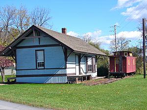
Restored depot
|
|

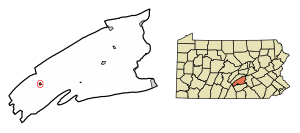
Location of Blain in Perry County, Pennsylvania.
|
|
| Country | United States |
| State | Pennsylvania |
| County | Perry |
| Settled | 1846 |
| Incorporated | 1877 |
| Area | |
| • Total | 0.32 sq mi (0.82 km2) |
| • Land | 0.32 sq mi (0.82 km2) |
| • Water | 0.00 sq mi (0.00 km2) |
| Elevation
(center of borough)
|
705 ft (215 m) |
| Highest elevation
(northern boundary)
|
730 ft (220 m) |
| Lowest elevation
(Sherman Creek)
|
675 ft (206 m) |
| Population
(2020)
|
|
| • Total | 229 |
| • Density | 720.13/sq mi (278.47/km2) |
| Time zone | UTC-5 (Eastern (EST)) |
| • Summer (DST) | UTC-4 (EDT) |
| Zip code |
17006
|
| Area codes | 717 and 223 |
| FIPS code | 42-06824 |
Blain is a small town, known as a borough, located in Perry County, Pennsylvania, United States. It is part of the larger Harrisburg metropolitan area. Blain is nestled in a beautiful valley region called Sherman's Valley. In 2020, about 227 people lived here.
Contents
History of Blain
Early settlers started a community around a mill built by James Blaine in 1778. The town was named after him. Over time, the "e" was dropped from the name.
How Blain Got Its Name
In the early 1800s, William Douglas owned Blaine's mill. He helped set up a post office named "Douglas' Mills." Later, Anthony Black bought the mill. He changed the post office name to "Multicaulisville." This was because he had a financial interest in a type of mulberry tree called morus multicaulis. There was a time when many people invested in these trees, hoping to make a lot of money. This was like a "bubble" where prices went up very fast.
In 1846, land was divided into lots and sold. The post office name was then changed to "Blain."
Town Development
Blain was once known for being the smallest borough in Pennsylvania. It had its own water plant and electric street lighting system. Jacob Wentz helped build the first water plant around 1869 or 1870. Blain officially became a borough on November 3, 1877. This happened by an order from the Perry County court.
Geography of Blain
Blain is located at 40°20′14″N 77°30′38″W / 40.33722°N 77.51056°W.
Area and Elevation
According to the United States Census Bureau, Blain covers about 0.3 square miles (0.8 square kilometers). All of this area is land. The average height of Blain above sea level is 750 feet (229 meters). The highest point nearby is Conegeuege Mountain, which is 1,872 feet (571 meters) tall.
Population of Blain
| Historical population | |||
|---|---|---|---|
| Census | Pop. | %± | |
| 1880 | 270 | — | |
| 1890 | 249 | −7.8% | |
| 1900 | 326 | 30.9% | |
| 1910 | 326 | 0.0% | |
| 1920 | 310 | −4.9% | |
| 1930 | 291 | −6.1% | |
| 1940 | 280 | −3.8% | |
| 1950 | 315 | 12.5% | |
| 1960 | 336 | 6.7% | |
| 1970 | 287 | −14.6% | |
| 1980 | 274 | −4.5% | |
| 1990 | 266 | −2.9% | |
| 2000 | 252 | −5.3% | |
| 2010 | 263 | 4.4% | |
| 2020 | 227 | −13.7% | |
| 2021 (est.) | 226 | −14.1% | |
| Sources: | |||
As of the census in 2000, there were 252 people living in Blain. There were 96 households and 67 families. Most residents were White (96.43%). A small percentage (3.57%) were African American.
Households and Families
Out of the 96 households, about 30% had children under 18 living with them. Most households (58.3%) were married couples living together. About 23% of households had people living alone. The average household had 2.63 people. The average family had 3.15 people.
Age and Income
The median age in Blain was 36 years old. This means half the people were younger than 36 and half were older. About 28% of the population was under 18. About 16% were 65 years or older.
The median income for a household in Blain was $32,500. For families, it was $39,750.
See also
 In Spanish: Blain (Pensilvania) para niños
 | Toni Morrison |
 | Barack Obama |
 | Martin Luther King Jr. |
 | Ralph Bunche |


