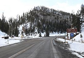
Blue Creek Canyon facts for kids
Quick facts for kids Blue Creek Canyon |
|
|---|---|
| Little Blue Creek Canyon | |
 |
|
| Floor elevation | 2,492 m (8,176 ft) |
| Length | 3.8 mi (6.1 km) N-S |
| Geography | |
| Location | Gunnison County, Colorado |
| Country | United States |
| State | Colorado |
| Borders on | Fitzpatrick Mesa and Blue Mesa |
| Topo map | Curecanti Needle |
| Traversed by | |
| Rivers | Blue Creek, Little Blue Creek and Big Blue Creek |
Blue Creek Canyon is a cool, deep canyon with steep sides in Gunnison County, Colorado. Imagine a giant crack in the Earth! This canyon is found between two flat-topped mountains called Fitzpatrick Mesa and Blue Mesa. It's also near Morrow Point Reservoir and the town of Cimarron, Colorado. A main road, U.S. Highway 50, actually runs right through the canyon. Another road, Gunnison County Road 867 (also known as Alpine Plateau Road), meets Highway 50 in the middle of the canyon.
Making the Highway Safer
The main road that goes through Blue Creek Canyon is quite narrow and has many turns. Because of this, it has been a spot where many car accidents have happened. To make the road safer, the U.S. Department of Transportation and other groups planned some big changes.
They planned to improve a 3.8-mile part of the highway inside the canyon. This work was set to start in the spring of 2021 and finish by the fall of 2022. The construction involved making the highway wider and paving the sides of the road (called shoulders). They also planned to put in new safety barriers (guardrails) and add fresh road signs and painted lines.
Because of all this work, the highway needed to be closed often, sometimes for long periods. This was necessary to keep workers and drivers safe during the improvements.
The Blue Creek River
Inside Blue Creek Canyon, two smaller streams, Little Blue Creek and Big Blue Creek, come together. When they meet, they form a larger stream simply called Blue Creek. This meeting point is right next to where Highway 50 and Alpine Plateau Road cross, near a bridge.
Right after the two smaller creeks join, Blue Creek flows under the bridge. It then travels north, running alongside the west side of the highway. After a while, Blue Creek turns away from the highway and heads northwest. Eventually, it flows into Morrow Point Reservoir near a famous rock formation called the Curecanti Needle.
Canyon Rocks and Minerals
The tall walls of Blue Creek Canyon are made of special types of rocks called metamorphic rocks. These rocks have been changed over a very long time by heat and pressure deep inside the Earth.
You can also see many large and small dikes in the canyon walls. A dike is like a wall of rock that cuts through other layers of rock. These dikes are made of a type of rock called pegmatite. Pegmatite is interesting because it often has very large crystals.
Some of these pegmatite dikes contain big, connected crystals of feldspar and pink quartz. Feldspar is a common mineral found in many rocks. Quartz is another very common mineral, and the pink kind is especially pretty!
 | Jewel Prestage |
 | Ella Baker |
 | Fannie Lou Hamer |


