Curecanti Needle facts for kids
Quick facts for kids Curecanti Needle, |
|
|---|---|
| Curecanti National Recreation Area (National Park Service) |
|

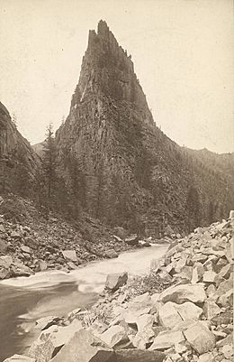
The Curecanti Needle photographed ca. 1884.
|
|
| Highest point | |
| Elevation | 7,739 ft (2,359 m) |
| Prominence | 700 ft (210 m) |
| Geography | |
| Location | Morrow Point Reservoir, Gunnison River, Gunnison County, Colorado, US |
| Topo map | Curecanti Needle MRC: 38107D4 U.S. Geological Survey (USGS) Topo Series:7.5´ Map Scale:1:24,000 |
The Curecanti Needle is a tall, thin rock formation in western Colorado. It stands about 700 feet (213 meters) high. This amazing granite spire is located right on the Gunnison River.
For many years, the Needle was a famous landmark. It was important to both native people and early settlers. Today, you can find it on the south side of Morrow Point Reservoir. This reservoir is a large lake formed by damming the Gunnison River.
The Curecanti Needle was once a symbol for a famous train company. The Denver and Rio Grande Western Railroad used it in their ads. Their trains ran right past the Needle. Now, this special rock is part of the Curecanti National Recreation Area. This area is managed by the National Park Service. It includes three reservoirs on the Gunnison River, including Morrow Point.
Contents
Where is the Curecanti Needle?
The Needle is found in the upper part of the Black Canyon of the Gunnison National Park. This area of the Gunnison River was flooded in 1965. This created the Morrow Point Reservoir.
The spire is on the south bank of the reservoir. It is just west of where Blue Creek joins the river. Right across the river is Curecanti Creek. The Needle is about 3.4 miles (5.5 km) west of Blue Mesa Dam.
A major road, U.S. Route 50, passes south of the Needle. This highway connects the towns of Gunnison and Montrose, Colorado.
The History of the Curecanti Needle
People knew about the upper Gunnison River area for a long time. Trappers, traders, and explorers visited it. But the Curecanti Needle became widely known in the 1880s. This was when the Denver & Rio Grande railroad was built.
How the Railroad Made the Needle Famous
The Denver & Rio Grande railroad wanted to expand. They built a line west along the Arkansas River. This line went through the Royal Gorge and into the San Juan Valley. They wanted to connect with another railroad coming from Utah.
So, the D&RG continued west from Salida. They crossed Marshall Pass and reached Gunnison in August 1881. West of Gunnison, the train tracks followed the north bank of the Gunnison River. This path led them into the upper Black Canyon.
The train line ran along the bottom of the canyon. It passed directly across the narrow river from the Curecanti Needle. This was between the towns of Sapinero and Cimmarron. The granite Needle quickly became a popular sight for passengers. People would stop and admire the unique rock.
The D&RGW was good at showing off the beautiful places their trains went. They used the Needle as a symbol for their "Royal Gorge route." They called it "The Scenic Line of the World." The Needle was put on train schedules and ads. It even became the main logo for the entire railroad in the early 1900s.
The Needle After the Railroad
The Needle remained a popular landmark until the 1950s. That's when the D&RGW stopped train service through the Black Canyon. This ended nearly a century of train travel there.
Just three years later, the train tracks near the Needle were covered by water. This happened when Morrow Point Reservoir was created. The Morrow Point Dam was built on the Gunnison River. This dam is part of the Colorado River Storage Project.
After being so famous, the area around the Needle became remote again. It was hard to reach. Since the reservoir was filled, the Needle is now part of the Curecanti National Recreation Area. The National Park Service manages this area. They develop and care for recreation spots on Morrow Point and other reservoirs.
How to Visit the Curecanti Needle
It's a bit tricky to get to the Curecanti Needle. There are no direct roads or easy trails right to it.
Getting There by Trail
The closest trail is the Curecanti Creek Trail. This trail goes down a steep path to Morrow Point Reservoir. It's on the opposite (north) side of the river from the Needle. But it offers great views for experienced hikers. There's also a campsite by the river.
- Curecanti Creek Trail: This trail is 4 miles (6.4 km) round-trip. It has a 900-foot (274 m) elevation change. You can find the trailhead at the Pioneer Point overlook. This is on Colorado Highway 92, about 5.7 miles (9.2 km) from U.S. Highway 50.
Getting There by Boat
You can reach the Needle directly by boat. But you have to carry your boat down the Pine Creek Trail. This trail has 232 steps! It's off U.S. Highway 50, west of Blue Mesa Dam.
Boaters on Morrow Point Reservoir need a free permit. You can get this at the Pine Creek Trailhead. Once on the water, you can go right to the base of the Needle along Blue Creek. There's a simple boat-in campsite at Blue Creek. Also, there's a developed campsite across from the Needle. It has a picnic table, grill, and toilet.
- Pine Creek Trail: This trail is 2 miles (3.2 km) round-trip. It has an 180-foot (55 m) elevation change. The trailhead is on U.S. Highway 50. It's about 1 mile (1.6 km) west of the junction with Colorado Highway 92. The boat launch is at the end of this trail.
See also
 In Spanish: Aguja Curecanti para niños
 | William Lucy |
 | Charles Hayes |
 | Cleveland Robinson |

