Bonchurch Landslips facts for kids
| Site of Special Scientific Interest | |

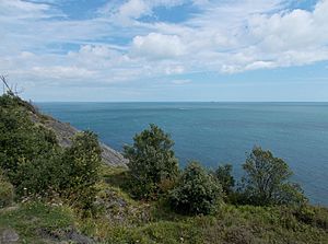
Scenery at the Landslip
|
|
| Area of Search | Isle of Wight |
|---|---|
| Grid reference | SZ582785 |
| Interest | Biological and Geological |
| Area | 28.2 hectare |
| Notification | 1977 |
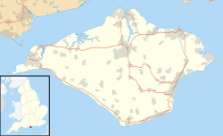
| Location map | Natural England |
The Bonchurch Landslips is a special area on the Isle of Wight. It covers about 28 hectares, which is like 40 football fields! This amazing place is found north-east of Ventnor. It's a coastal area with lots of trees where the land has slipped.
Scientists officially recognized this spot in 1977. They found it important for both its plants and animals, and its unique geology (how the earth is formed). It's part of the Undercliff area of the Isle of Wight. You can explore it using several footpaths. Some paths even go through cool rock gaps like the Devil's Chimney and 'The Chink'.
Contents
Why are the Bonchurch Landslips Special?
The Bonchurch Landslip is also known as the East End Landslip. It's a "SSSI" because of its amazing landforms and plants. This means it's a protected area.
How the Land was Formed
The land here is made of different layers of rock and clay. Harder rocks called Upper Greensand sit on top of softer Gault clay. Over time, the soft clay can get wet and slippery, causing the land above it to slide. This creates the unique landscape you see today.
Amazing Plants and Trees
The Gault clay helps many trees grow, like ash, oak, and beech. You can also find unusual types of lichen here. In the lower parts of the slips, where clay and sand mix, you'll discover a variety of plants. Some love acidic soil, while others prefer chalky soil. This mix makes the area very special for nature lovers.
A Shifting History: How the Landslips Formed
People believe the Bonchurch Landslip has been around for thousands of years. But its current look mostly comes from two big landslides. These happened in 1810 and 1818.
What Happened During the Landslides?
A geologist named Thomas Webster described the scene in 1811. He was amazed by the damage. Huge parts of the cliff had fallen down, covering the ground between the cliff and the sea. Big rocks were mixed with smaller pieces. Even soil with wheat still growing on it had slid down, forming hills of rubble.
Nothing could stop the falling rocks. Trees were knocked over, and some were half-buried. Streams were blocked, and pools of water formed. Any old roads or paths were gone. It was difficult to walk through this "avalanche" of land.
Exploring the Landslips: Victorian Walks
In Victorian times, people turned the Bonchurch Landslip into a beautiful woodland walk. They enjoyed its natural features. These include the Devil's Chimney and The Chink, which are narrow rock passages. There's also the Wishing Seat, a large rock covered in moss.
Recent Land Movement
Even today, the land can still move. A smaller slip happened in February 1995. The main village of Bonchurch is on a stable part of the land. However, the edge next to the Landslip is still active. For example, in 2011, some land movement affected a Victorian house called North Court.
 | Mary Eliza Mahoney |
 | Susie King Taylor |
 | Ida Gray |
 | Eliza Ann Grier |


