Undercliff (Isle of Wight) facts for kids
For other locations of the same name, see The Undercliff.
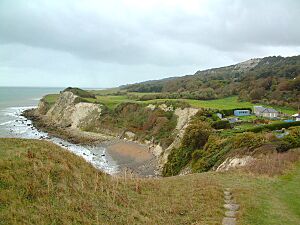
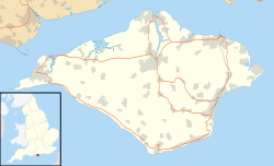
The Undercliff on the Isle of Wight, England, is a special strip of land. It's about 5 miles (8 km) long and 0.25 to 0.5 miles (0.4 to 0.8 km) wide. This unique area runs along the southern coast of the island, from Niton to Bonchurch. It gets its name because it sits below a steep slope or cliff, called an escarpment.
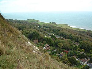
The land here is hilly and uneven. It has a mix of grassy fields, young forests, park areas, and large houses. Because it faces south and is protected by the cliffs, the Undercliff has its own microclimate. This means it's much warmer here than in other parts of the island. Even though people live here, the Undercliff is known for landslides and the ground sinking over time. This has caused some buildings to be lost. The main places you'll find along the Undercliff are lower Niton, Puckaster, St Lawrence, Steephill, the town of Ventnor, and Bonchurch.
Contents
How the Undercliff Was Formed

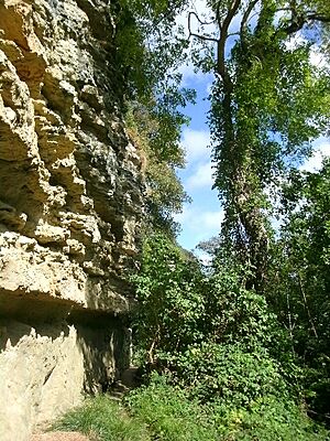
The Undercliff is a huge area where the ground has moved a lot. It's made of soft rocks from the Cretaceous period, which was a very long time ago. Think of it as a natural shelf of slipped clays and sands, sitting above a low sea-cliff. Behind it are much taller cliffs (about 100 meters high) made of Upper Greensand and Chalk. This is the biggest urban landslide area in northern Europe!
Most of the land movement happened in two main periods after the last Ice age. The first was between 8,000 and 4,500 years ago, and the second was between 2,500 and 1,800 years ago. On either side of the Undercliff, there are areas where the ground still moves a lot. These include the Blackgang landslip to the west and the Bonchurch Landslips to the east.
The main part of the Undercliff is more stable. However, there are still worries about the coast wearing away, more ground slipping, and sinking. For example, the main road, Undercliff Drive, was damaged by a mudslide near St Lawrence in 2001. It took 18 months to build a new section. In 2014, heavy rain caused more damage, and nine houses had to be emptied.
The heavy chalk rocks of St Boniface Down, the highest chalk hill on the Isle of Wight, sit above the softer rocks of the Undercliff near Ventnor. Because of this, the ground in Upper Ventnor (also called Lowtherville) is slowly moving towards the cliff edge. This is called 'The Graben'. This constant change in the land also explains why the roads in and out of Ventnor are so unique, offering amazing views of Sandown Bay and the English Channel. The shelter from St Boniface Down also helps create Ventnor's warm climate.
A Look Back in Time

People have lived in the stable parts of the Undercliff for a very long time. There are old churches in Bonchurch and St Lawrence. Also, archaeologists have found signs that people lived here during the Paleolithic (Old Stone Age) and Neolithic (New Stone Age) times.
Before the 1800s, the Undercliff was home to several large estates. One famous estate was at Steephill.
In the mid-1800s, the Undercliff became a popular place to build. Many beautiful "cottages orné" (fancy cottages) and large seaside villas were built with lovely gardens. These included Steephill Castle. Many famous people from the Victorian era rented or owned homes here, especially in Bonchurch. These included writers like Thomas Carlyle and Charles Dickens.
Development also spread west towards Blackgang, partly because building was popular and partly because the Blackgang Chine amusement park was being built. However, most of these properties have been destroyed by landslides and coastal erosion over the last 100 years.
Ventnor became very popular as a health and holiday resort starting in 1830. A doctor named Arthur Hill Hassall, who had tuberculosis, moved to the Isle of Wight in 1869. He noticed how good the climate was in the Undercliff. Because of this, he opened a special hospital for lung diseases east of Ventnor. Even though the hospital closed in 1964, its grounds were turned into the Ventnor Botanic Garden. This garden is 22 acres (8.9 ha) big and uses the mild weather to grow plants from warm places all over the world.
Later, other famous people lived in the Undercliff, including writers Alfred Noyes and Aubrey de Sélincourt, and the sailor Uffa Fox.
Getting Around the Undercliff
The main road through the Undercliff is the A3055 road, which runs from Niton to Bonchurch. West of Ventnor, the Southern Vectis 3 bus travels along Undercliff Drive as far as St Lawrence. The Southern Vectis 6 bus goes north-east from Ventnor to Bonchurch and beyond.
The road that used to connect Niton and Blackgang was broken by landslides in the 1900s. More recently, the road between St Lawrence and Niton collapsed in two places in February 2014. This happened because the ground moved after a lot of rain. Now, cars cannot travel directly between St Lawrence and Niton on the old road; they have to go a different way through Whitwell. However, people can walk or cycle along the path again since late 2016. Bus routes have changed and no longer stop in St Lawrence.
A few steep roads, locally called "shutes," connect the top of the cliff to the lower Undercliff area. These include Niton Shute, St Lawrence Shute, and Bonchurch Shute.
The Undercliff used to have train stations in Ventnor (Ventnor railway station and Ventnor West) and St Lawrence.
You can explore the area on foot using the Ventnor-Blackgang section of the Isle of Wight Coastal Path. There are also many other scenic walks along and below the cliffs that back the Undercliff. These include Gore Cliff east of Niton, the 'Cripple Path' and 'St Rhadegund's Path' that climb the inner cliff at Niton and St Lawrence, the Devil's Chimney, and the Bonchurch Landslips.
Cool Places to Visit
- Blackgang Chine
- Bonchurch Landslips
- The Chink
- The Devil's Chimney
- Old St. Boniface Church, Bonchurch
- St. Boniface Church, Bonchurch
- St. Catherine's Lighthouse
- St Lawrence Old Church
- Steephill Cove
- Ventnor Botanic Garden
- Ventnor Museum
 | Laphonza Butler |
 | Daisy Bates |
 | Elizabeth Piper Ensley |


