Boscastle to Widemouth facts for kids
| Site of Special Scientific Interest | |

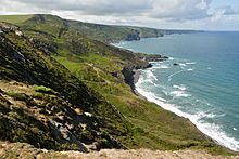
High Cliff, showing the characteristic slumping creating an undercliff
|
|
| Area of Search | Cornwall |
|---|---|
| Coordinates | 50°45′53″N 4°36′10″W / 50.7646°N 4.6027°W |
| Interest | Biological/Geological |
| Area | 639 hectares (6.390 km2; 2.467 sq mi) |
| Notification | 1972 |
Boscastle to Widemouth is a fantastic coastal area in Cornwall, England. It's so special that it's been named a Site of Special Scientific Interest (SSSI). This means it's super important for its amazing plants, animals, and unique rocks. One of the most special parts is the Dizzard dwarf oak woodland. It's famous around the world for its incredible collection of lichens, with 131 different kinds found there!
Contents
Exploring Boscastle to Widemouth
This special area covers about 639 hectares (that's like 1,579 football fields!). It stretches along the north Cornish coast, right next to the Celtic Sea (which is part of the Atlantic Ocean). The coastline is about 12 miles (19 km) long, going from Boscastle in the south up to Widemouth Bay in the north.
Amazing Cliffs and Landscapes
The coast near Crackington Haven is really unique. Instead of super steep cliffs, the land has slowly collapsed over time. This creates "undercliffs" that are covered in thick plants. Some of these areas are even grazed by cows and horses. This mix of different natural places, like coastal heath and grassland, is really important for nature in the UK. You'll also find High Cliff here, which is the tallest cliff in Cornwall, standing at 223 meters (732 feet) high!
The famous South West Coast Path runs right through this SSSI, so you can walk along and see all the amazing sights. Parts of this coast are looked after by the National Trust, a charity that protects special places.
Ancient Rocks and Earth Movements
The rocks along this coast are very old, dating back about 326 to 313 million years ago. They are mostly a type of shale called the Crackington formation. These rocks were formed from mud and sand at the bottom of an ancient sea. Later, huge earth movements, like continents colliding, folded and twisted these layers of rock. You can see these amazing folded layers best at Crackington Haven and Millook.
During the Quaternary Period, which was a very cold time, this area was covered in frozen soil and was just south of a huge ice sheet.
There are five special spots within this SSSI that geologists study closely. They are:
- Boscastle
- Millook to Foxhole Point
- Rusey Cliff to Buckator
- Widemouth to Crackington
- Widemouth to Saltstone Strand
Wildlife and Nature
The valleys along this coast, like Crackington Haven and Dizzard, are home to many different types of plants and animals. You can see how the plant life changes as you move from the sea's edge to the woodlands.
Plants of the Coast
Right by the sea, in the "splash zone" where waves hit, you'll find colorful lichens. They can be black, orange, or grey. On rock ledges, you might spot plants like rock samphire, sea spleenwort, and thrift.
Coastal Grasslands and Heaths
Where the ground is less steep, you'll find grassy areas with lots of wildflowers. Common plants here include bird's-foot trefoil, wild thyme, and sea campion.
Higher up, exposed to the wind, are coastal heaths. These areas have a wavy look because of the strong winds. You'll see plants like heather, bell heather, and western gorse.
Scrub and Woodland Birds
The scrub areas have bushes like blackthorn, gorse, and bramble. In these areas, you might spot birds like the stonechat, linnet, and whitethroat.
The Unique Dizzard Woodland
The Dizzard woodland is truly special! It's about 2 miles (3 km) long and runs between Crackington Haven and Millook. This "dwarf" woodland grows on exposed cliffs, and its trees are mostly sessile oak. They are short, from one to eight meters tall, because of the strong, salty winds from the sea.
What makes this woodland internationally important are the Lobarion communities of lichens that cover the trees. These lichens are very rare and sensitive to pollution. Some of the main species include Lobaria pulmonaria and Pseudocyphellaria crocata, which is found in only one other place in England and Wales!
The ground beneath the trees has plants like ramsons and meadowsweet in wetter spots. In drier areas, you'll find ling and bilberry. The National Trust helps look after this woodland by removing plants that don't belong, like sycamore trees.
The Large Blue Butterfly
The large blue butterfly is a beautiful insect that was once found at Millook in 1891. It was a very exciting discovery because this butterfly was becoming rare in other parts of England. For a while, it was quite common in Cornwall, even as far west as Tintagel.
However, over time, the butterfly's numbers started to drop. This was mainly because its habitat changed. For example, some areas where it lived were plowed, and gorse bushes grew too much, covering up the wild thyme that the butterfly's caterpillars eat. The butterfly also needs a specific type of ant to complete its life cycle. When rabbit numbers dropped due to a disease, it also led to more gorse growing, which further harmed the butterfly's habitat.
The large blue butterfly was last seen in Cornwall in 1973. However, there's good news! In 2000, efforts were made to reintroduce this amazing butterfly to a site in north Cornwall, helping it return to its former home.
 | Selma Burke |
 | Pauline Powell Burns |
 | Frederick J. Brown |
 | Robert Blackburn |

