
Boulder Mountains (Idaho) facts for kids
Quick facts for kids Boulder Mountains |
|
|---|---|

Boulder Mountains and Big Wood River
|
|
| Highest point | |
| Peak | Ryan Peak |
| Elevation | 11,714 ft (3,570 m) |
| Dimensions | |
| Length | 55 mi (89 km) N/S |
| Width | 38 mi (61 km) E/W |
| Area | 743 sq mi (1,920 km2) |
| Geography | |

Boulder Mountains
Location in Idaho

Boulder Mountains
Location in the United States
|
|
| Country | United States |
| State | Idaho |
| Parent range | Rocky Mountains |
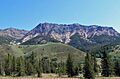
The Boulder Mountains are a cool mountain range in central Idaho, United States. They are part of the bigger Rocky Mountains. These mountains stretch from near Ketchum up to Challis. Part of them are even in special protected areas like the Sawtooth National Recreation Area. The very top of these mountains is Ryan Peak, which stands super tall at 11,714 feet (about 3,570 meters) above sea level!
In summer, many people love to hike the trails in the southern Boulder Mountains. This is where you'll find the tallest peaks! You can easily see the mountains from Highway 75, also known as the Sawtooth Scenic Byway. Near the Big Wood River, you'll see lots of trees. But as you go further north, the landscape changes to more sagebrush plants. Did you know a movie was filmed here? Part of the 1985 movie Pale Rider was shot in these mountains in 1984.
Tallest Mountains in the Boulders
The Boulder Mountains have many high points. Here are some of the tallest peaks you can find in this range:
- Ryan Peak: This is the highest point in the Boulder Mountains, reaching 11,714 feet (3,570 meters).
- Kent Peak: Another tall peak, standing at 11,663 feet (3,555 meters).
- Glassford Peak: This peak is 11,598 feet (3,536 meters) high.
- Peak 11,458: This mountain reaches 11,458 feet (3,492 meters).
- Peak 11,313: Standing at 11,313 feet (3,448 meters).
- Peak 11,298: This peak is 11,298 feet (3,444 meters) tall.
- Peak 11,240: Reaching 11,240 feet (3,426 meters).
- Peak 11,192: This peak is 11,192 feet (3,411 meters) high.
- Peak 11,161: Standing at 11,161 feet (3,402 meters).
- Cerro Ciento: This peak is 11,155 feet (3,400 meters) tall.
Beautiful Lakes of the Boulder Mountains
The Boulder Mountains are home to several beautiful lakes. These lakes are often found high up in the mountains and are fed by melting snow and streams. They are great spots for enjoying nature. Here are some of the named lakes:
- Big Fall Creek Lake: Located at 9,078 feet (2,767 meters) elevation. Its main outflow is Big Fall Creek.
- Governor's Punch Bowl: This lake is at 8,655 feet (2,638 meters) elevation. Water flows out into Horse Creek.
- Lower Deer Lake: Found at 9,514 feet (2,900 meters) elevation. Its water flows into Deer Creek.
- North Amber Lake: At 9,042 feet (2,756 meters) elevation. It flows into the West Fork Big Wood River.
- North Fork Lake: This lake is at 9,344 feet (2,848 meters) elevation. Its water goes into the North Fork Big Lost River.
- Silver Lake: Located at 9,678 feet (2,950 meters) elevation. Its outflow is Silver Creek.
- South Amber Lake: At 9,153 feet (2,790 meters) elevation. It also flows into the West Fork Big Wood River.
- Upper Deer Lake: Found at 9,616 feet (2,931 meters) elevation. Its water also flows into Deer Creek.
- Window Lake: This lake is at 10,036 feet (3,059 meters) elevation. It flows into the West Fork Big Wood River.
Images for kids
-
Boulder Mountains
-
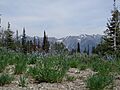
Boulder Mountains from Galena Summit
-
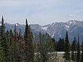
Boulder Mountains from Galena Summit
-
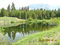
Pond below the Boulder Mountains


