
Bradford, Rhode Island facts for kids
Quick facts for kids
Bradford, Rhode Island
|
|
|---|---|

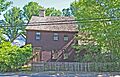
Solomon P. Wells House in the historic district
|
|

Bradford, Rhode Island
Location in Rhode Island
|
|
| Country | United States |
| State | Rhode Island |
| County | Washington |
| Area | |
| • Total | 1.83 sq mi (4.75 km2) |
| • Land | 1.82 sq mi (4.71 km2) |
| • Water | 0.01 sq mi (0.04 km2) |
| Elevation | 39 ft (12 m) |
| Population
(2020)
|
|
| • Total | 1,457 |
| • Density | 801.87/sq mi (309.55/km2) |
| Time zone | UTC-5 (Eastern (EST)) |
| • Summer (DST) | UTC-4 (EDT) |
| ZIP code |
02808
|
| Area code(s) | 401 |
| FIPS code | 44-08020 |
| GNIS feature ID | 1217668 |
|
Bradford Village Historic District
|
|
| Lua error in Module:Location_map at line 420: attempt to index field 'wikibase' (a nil value). | |
| Location | Westerly and Hopkinton |
|---|---|
| Built | 1732 |
| Architect | Sherman, R.A., Sons & Co. |
| Architectural style | Bungalow/Craftsman, Tudor Revival, Greek Revival |
| NRHP reference No. | 96000573 |
| Added to NRHP | May 30, 1996 |
Bradford is a small community in Rhode Island, United States. It's known as a census-designated place (CDP), which means it's an area identified by the government for statistics, and also a historic district. Bradford is located in two towns: Westerly and Hopkinton, both in Washington County, Rhode Island.
In 2020, about 1,457 people lived in Bradford. The Bradford Village Historic District was added to the National Register of Historic Places in 1996. This means it's a special area recognized for its historical importance, covering about 224 acres and including 149 historic buildings. The part of Bradford that the Census Bureau tracks is only in Westerly.
Bradford got its name from a town called Bradford in West Yorkshire, England.
Contents
Where is Bradford?
Bradford is located at specific geographic coordinates: 41.400657 degrees North and 71.747607 degrees West. These numbers help pinpoint its exact spot on a map.
The village covers a total area of about 4.9 square kilometers (or 1.9 square miles), and all of this area is land.
People of Bradford
| Historical population | |||
|---|---|---|---|
| Census | Pop. | %± | |
| 2020 | 1,457 | — | |
| U.S. Decennial Census | |||
Population in 2020
The 2020 United States census counted 1,457 people living in Bradford. There were 556 households, which are groups of people living together, and 312 families.
Most people in Bradford (about 84.76%) are white. There are also smaller groups of people from other backgrounds, including African American, Native American, Asian, and Pacific Islander. About 3.64% of the population is Hispanic or Latino.
About 28.4% of the households had children under 18 years old. Many households (47.8%) were married couples living together. The average household had 2.4 people, and the average family had 2.9 people.
The median age in Bradford was about 39.6 years old. This means half the people were younger than 39.6 and half were older.
Protecting the Environment
Bradford is a community where the Bradford Dyeing Association (BDA) operated for almost 100 years. This company was a major producer of fabrics for military uniforms.
Over time, the BDA plant caused some pollution in the local area, affecting the Pawcatuck River and the air. When local complaints about the pollution weren't being addressed, a community group called the Bradford Coalition 2 Stop Pollution formed. They worked to reduce the pollution from the BDA.
In 2005, a lawsuit was filed against the company with the help of groups like the Toxic Action Center, RIPIRG, and the Sierra Club. The BDA agreed to pay fines and make changes to their factory to reduce pollution. These changes included building taller smokestacks and improving how they managed waste.
An advocate from RIPIRG, Matthew Auten, explained that this agreement showed how important it is for citizens to help make sure environmental laws are followed. The BDA eventually closed down in 2019, and the site was sold.
Images for kids
-
Solomon P. Wells House in the historic district
See also
 para niños")
