Brandon, Queensland facts for kids
Quick facts for kids BrandonQueensland |
|||||||||||||||
|---|---|---|---|---|---|---|---|---|---|---|---|---|---|---|---|
| Population | 1,088 (2021 census) | ||||||||||||||
| • Density | 9.846/km2 (25.50/sq mi) | ||||||||||||||
| Postcode(s) | 4808 | ||||||||||||||
| Area | 110.5 km2 (42.7 sq mi) | ||||||||||||||
| Time zone | AEST (UTC+10:00) | ||||||||||||||
| Location |
|
||||||||||||||
| LGA(s) | Shire of Burdekin | ||||||||||||||
| State electorate(s) | Burdekin | ||||||||||||||
| Federal Division(s) | Dawson | ||||||||||||||
|
|||||||||||||||
Brandon is a small town in Queensland, Australia. It is a rural locality in the Shire of Burdekin. In 2021, about 1,088 people lived there. Brandon is known for its sugarcane farms.
Contents
A Look Back in Time
Brandon was planned as a town in 1882. This is when the first pieces of land were sold. The town was named after Henry Brandon. He was important in starting sugar farms in the Mackay and Lower Burdekin areas.
The Brandon Post Office opened on September 6, 1883. Before that, a smaller mail office served the area. It was called Pioneer Estate.
Kids in Brandon got their first school on April 9, 1888. It was first called Brandon Provisional School. Later, in 1898, it became Brandon State School. Another school, Kalamia State School, opened in 1928 near the Kalamia Sugar Mill.
Special Places in Brandon
Brandon has some special buildings that are "heritage-listed." This means they are important parts of history and are protected.
- St Patrick's Catholic Church on Spiller Street is one of these places.
What Brandon Does
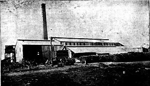
Brandon is a big area for growing sugarcane. Farmers use underground water to help their crops grow. Wilmar Sugar Australia runs two sugar mills in Brandon. These mills process the sugarcane into sugar.
- The Kalamia Sugar Mill is in the north-east of Brandon.
- The Pioneer Sugar Mill is in the west of Brandon.
Learning in Brandon
Brandon has two primary schools for younger students:
- Brandon State School is a government primary school for students from Prep (the first year of school) to Year 6. It is located on Drysdale Street. In 2017, about 45 students went to this school.
- Kalamia State School is also a government primary school for students from Prep to Year 6. It is on Lilliesmere Road. In 2017, it had about 14 students.
There are no high schools in Brandon itself. Students usually go to Ayr State High School in the nearby town of Ayr.
Fun and Sport
Pioneer Park Speedway is a place where people race motorcycles. It is located south-west of Brandon on the Bruce Highway. This track has hosted big motorcycle racing events. These include qualifying rounds for the Speedway World Championship. It has also hosted the final race of the Australian Solo Championship.
 | DeHart Hubbard |
 | Wilma Rudolph |
 | Jesse Owens |
 | Jackie Joyner-Kersee |
 | Major Taylor |


