
Ayr, Queensland facts for kids
Quick facts for kids AyrQueensland |
|||||||||||||||
|---|---|---|---|---|---|---|---|---|---|---|---|---|---|---|---|

Burdekin Hotel, Ayr, 2010
|
|||||||||||||||

Ayr
Location in Queensland
|
|||||||||||||||
| Population | 8,603 (2021 census) | ||||||||||||||
| • Density | 295.6/km2 (766/sq mi) | ||||||||||||||
| Established | 1882 | ||||||||||||||
| Postcode(s) | 4807 | ||||||||||||||
| Elevation | 12.0 m (39 ft) | ||||||||||||||
| Area | 29.1 km2 (11.2 sq mi) | ||||||||||||||
| Time zone | AEST (UTC+10:00) | ||||||||||||||
| Location |
|
||||||||||||||
| LGA(s) | Shire of Burdekin | ||||||||||||||
| State electorate(s) | Burdekin | ||||||||||||||
| Federal Division(s) | Dawson | ||||||||||||||
|
|||||||||||||||
|
|||||||||||||||
Ayr is a country town and area in the Shire of Burdekin, Queensland, Australia. It's known as the heart of a big sugarcane farming region. Ayr is also where the local council, the Burdekin Shire Council, has its main office. In 2021, about 8,603 people lived in Ayr.
Contents
What is Ayr Like?
Ayr is located about 88 kilometres (55 miles) south of Townsville. You can find it along the Bruce Highway. It's also 12 kilometres (7.5 miles) from the smaller town of Home Hill. Ayr is close to the Burdekin River delta. The Burdekin Shire grows more sugar cane per square kilometre than anywhere else in Australia. This is possible because of underground water and water from the Burdekin Dam.
There are a few smaller areas within Ayr. Mirrigan is one neighbourhood. Its name comes from an old railway station and means "star" in an Aboriginal language. Another area is Parkside, located in the south-east of the town.
The Ayr railway station is on the main North Coast railway line. It's a stop for the Spirit of Queensland passenger train. There's also a railway siding called Kalamia Sidings. This is part of the Kalamia Sugar Mill's special railway for sugar cane.
Ayr's Weather
Ayr has a tropical savannah climate. This means it has a short wet season from December to April. The rest of the year, from May to November, is a long dry season. Most of the rain falls during the Australian summer. The average yearly rainfall is about 944 millimetres (37 inches). Temperatures in Ayr can range from 1.4°C (34.5°F) in winter to 44.0°C (111.2°F) in summer.
| Climate data for Ayr (19º37'12"S, 147º22'48"E, 17 m AMSL) (1951-2024 normals and extremes) | |||||||||||||
|---|---|---|---|---|---|---|---|---|---|---|---|---|---|
| Month | Jan | Feb | Mar | Apr | May | Jun | Jul | Aug | Sep | Oct | Nov | Dec | Year |
| Record high °C (°F) | 44.0 (111.2) |
40.6 (105.1) |
37.2 (99.0) |
36.0 (96.8) |
33.2 (91.8) |
32.2 (90.0) |
32.5 (90.5) |
34.1 (93.4) |
36.5 (97.7) |
38.0 (100.4) |
41.9 (107.4) |
42.5 (108.5) |
44.0 (111.2) |
| Mean daily maximum °C (°F) | 31.8 (89.2) |
31.6 (88.9) |
31.0 (87.8) |
29.6 (85.3) |
27.6 (81.7) |
25.5 (77.9) |
25.2 (77.4) |
26.3 (79.3) |
28.2 (82.8) |
30.0 (86.0) |
31.2 (88.2) |
32.1 (89.8) |
29.2 (84.5) |
| Mean daily minimum °C (°F) | 22.8 (73.0) |
22.8 (73.0) |
21.6 (70.9) |
19.1 (66.4) |
16.2 (61.2) |
13.0 (55.4) |
11.9 (53.4) |
12.7 (54.9) |
15.2 (59.4) |
18.2 (64.8) |
20.7 (69.3) |
22.1 (71.8) |
18.0 (64.5) |
| Record low °C (°F) | 17.4 (63.3) |
16.7 (62.1) |
11.9 (53.4) |
8.5 (47.3) |
3.7 (38.7) |
2.2 (36.0) |
1.4 (34.5) |
2.0 (35.6) |
5.6 (42.1) |
7.7 (45.9) |
11.5 (52.7) |
12.5 (54.5) |
1.4 (34.5) |
| Average precipitation mm (inches) | 230.5 (9.07) |
231.0 (9.09) |
149.0 (5.87) |
52.3 (2.06) |
41.1 (1.62) |
23.3 (0.92) |
17.9 (0.70) |
15.4 (0.61) |
9.7 (0.38) |
26.4 (1.04) |
45.2 (1.78) |
99.7 (3.93) |
943.9 (37.16) |
| Average precipitation days (≥ 1.0 mm) | 9.6 | 10.3 | 7.8 | 3.6 | 3.1 | 2.3 | 1.7 | 1.6 | 1.2 | 2.2 | 4.0 | 5.7 | 53.1 |
| Average afternoon relative humidity (%) | 64 | 68 | 61 | 59 | 54 | 54 | 47 | 47 | 49 | 53 | 57 | 58 | 56 |
| Average dew point °C (°F) | 22.6 (72.7) |
23.1 (73.6) |
21.5 (70.7) |
19.3 (66.7) |
16.1 (61.0) |
13.9 (57.0) |
11.5 (52.7) |
12.2 (54.0) |
14.7 (58.5) |
17.5 (63.5) |
19.6 (67.3) |
21.3 (70.3) |
17.8 (64.0) |
| Mean monthly sunshine hours | 251.1 | 203.4 | 229.4 | 234.0 | 229.4 | 231.0 | 257.3 | 269.7 | 276.0 | 291.4 | 273.0 | 275.9 | 3,021.6 |
| Percent possible sunshine | 62 | 56 | 61 | 67 | 66 | 70 | 75 | 76 | 77 | 75 | 70 | 67 | 69 |
| Source: Bureau of Meteorology (1951-2024 normals and extremes) | |||||||||||||
How Did Ayr Begin?
Early History
The Biri (Birri) language is spoken by Aboriginal people in Central and North Queensland. This language group covers areas including Ayr, Bowen, and Collinsville.
The first British explorers came to the Ayr area in 1839. Captain John Clements Wickham sailed up the Burdekin River. He found a fishing weir built by the local Aboriginal people.

In 1843, another ship, HMS Fly, explored the river further. Lieutenant John Ince and others met two large groups of Aboriginal people. They had friendly meetings, sharing items and taking part in a special welcome ceremony. An artist named Harden Sidney Melville drew a picture of this meeting.
James Morrill was a shipwreck survivor who lived with Aboriginal people here for 17 years. He learned their way of life and later wrote important records about his experiences.
More British explorers came in the 1850s and 1860s. George Elphinstone Dalrymple explored the land in 1859 and 1860. He thought the area would be great for farming and raising animals.
British Settlers Arrive
In 1861, the land was opened up for settlers to start farms. Edward Spencer Antill started a large sheep farm called Jarvisfield in 1862. More settlers arrived, and a town called Wickham was formed in 1864. However, a big flood in 1870 destroyed it.
The town of Ayr was planned out in 1881 by a surveyor named Ellis William Lymburner. It was named after a town in Scotland, Ayr, which was the birthplace of Sir Thomas McIlwraith, a leader in Queensland. The Ayr Post Office opened in 1883.
Growing Sugar Cane
Big sugar cane farms started in the Ayr area in 1879. Robert William Graham and Archibald Campbell MacMillan started a plantation called Airdmillan. They built the Airdmillan sugar mill in 1883.

Other settlers also started sugar cane farms and mills in the 1880s. These included the Pioneer plantation and mill, and the Kalamia plantation and mill. Many workers on these early plantations were South Sea Islanders. Today, the Pioneer, Kalamia, and Inkerman mills are still working. They are owned by Wilmar Sugar.
Schools in Ayr
Ayr State School first opened in 1886. It later grew to include a high school. In 1937, Ayr State High School became its own separate school.
St Francis Primary School opened in 1912. It was run by three Sisters of the Good Samaritan.

The Ayr War Memorial Arch was built in 1925 to remember those who served in World War I. It is the entrance to the Memorial Park.
East Ayr State School opened in 1952. Ayr also has a special school for children with disabilities, which is now called Burdekin School. It opened in 1972.
Burdekin Catholic High School opened in 1974. Burdekin Christian College opened in 1982. The Burdekin Library, a public library, opened in 1984.
Heritage Buildings
Ayr has several buildings that are important to its history. These are called heritage-listed sites. They include:
- Ayr Post Office, located on Queen Street.
- Ayr Court House, also on Queen Street.
- Ayr Masonic Temple on Macmillan Street.
- Ayr State High School on Wickham Street.
- Burdekin Shire Council Chambers on Young Street.
Education in Ayr
Ayr has many schools for students of all ages:
- Ayr State School is a government primary school (Prep to Year 6).
- East Ayr State School is another government primary school (Prep to Year 6). It also has a special education program.
- St Francis' School is a Catholic primary school (Prep to Year 6).
- Burdekin Christian College is a private school that teaches students from Prep all the way to Year 12.
- Burdekin School is a special school for children with disabilities, from early childhood to Year 12.
- Ayr State High School is a government secondary school (Years 7 to 12). It also has a special education program.
- Burdekin Catholic High School is a Catholic secondary school (Years 7 to 12).
Facilities and Shops
Ayr has a small hospital that offers basic emergency care. It also has a helipad for serious emergencies. You can find many shops and banks in Ayr.
The Burdekin Shire Council runs a public library in Ayr. The Ayr branch of the Queensland Country Women's Association also meets here. The Burdekin Uniting Church has a church in Ayr and another in Home Hill.
Fun Things to Do
Ayr is a great place for sports! You can play touch football, rugby league, rugby union, soccer, tennis, and golf. Netball and table tennis are also popular. The Ayr Surf Life Saving club is a small but well-known club.
Pioneer Park Speedway is a place where motorcycle speedway races happen. It has hosted big events, including parts of the Speedway World Championship.
If you like the beach, Alva Beach (also called Lynch's Beach) is a popular spot. It's about 16 kilometres (10 miles) east of Ayr and is great for fishing and swimming.
Getting Around Ayr
Ayr's main street, Queen Street, is wide with two lanes. The A1 highway goes through the town. This highway is the main road in the Burdekin area, connecting Ayr to nearby Brandon and Home Hill.
Ayr Railway Station is where you can catch trains. There are regular train services from Brisbane to Cairns. While Ayr doesn't have public buses for everyone, there are bus routes for school children.
Famous People from Ayr
Many talented people have come from Ayr, including:
- Mark Allison: a business leader.
- Zachary Anderson: a football (soccer) player.
- Tarin Bradford: a rugby league player.
- Nathan Burgers: a field hockey player.
- Patricia Cockrem: a former Australian basketball player.
- Mitchell Davey: a motorcycle speedway rider.
- Matthew Ham: a football (soccer) player.
- Jackie Huggins: an Aboriginal author and historian.
- Johnny Nicol: a jazz singer.
- Kel O'Shea: a famous Australian rugby league player.
- Ryan Phelan: a journalist and TV presenter.
- Heath Tessmann: a rugby union player.
- Don Walker: a musician and songwriter for the band Cold Chisel.
- Karrie Webb: a professional golfer and member of the LPGA Hall of Fame.
- Ray Wilkie: a meteorologist (weather forecaster).
Images for kids
-
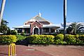
The Ayr Post Office, a heritage-listed building.
-
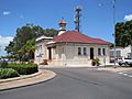
The Ayr Court House, built in 1901.
-
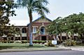
Ayr State High School, which became a separate school in 1937.
-
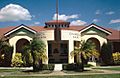
The Burdekin Shire Council Chambers, where local government decisions are made.


See also
 In Spanish: Ayr (Australia) para niños
