Jarvisfield, Queensland facts for kids
Quick facts for kids JarvisfieldQueensland |
|||||||||||||||
|---|---|---|---|---|---|---|---|---|---|---|---|---|---|---|---|

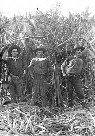
The Olsen brothers, Sugarcane farmers in Jarvisfield, circa 1920
|
|||||||||||||||
| Population | 367 (2016 census) | ||||||||||||||
| • Density | 3.303/km2 (8.55/sq mi) | ||||||||||||||
| Postcode(s) | 4807 | ||||||||||||||
| Area | 111.1 km2 (42.9 sq mi) | ||||||||||||||
| LGA(s) | Shire of Burdekin | ||||||||||||||
| State electorate(s) | Burdekin | ||||||||||||||
| Federal Division(s) | Dawson | ||||||||||||||
|
|||||||||||||||
Jarvisfield is a coastal area in Queensland, Australia. It is part of the Shire of Burdekin. This small community is mostly made up of flat land. It is famous for growing lots of sugarcane.
Contents
Exploring Jarvisfield's Location
Jarvisfield is located right next to the Coral Sea on its eastern side. The Burdekin River forms its southern border. A waterway called Plantation Creek is to the north.
Land and Farming
The land in Jarvisfield is very flat and low. It is less than 10 meters (about 33 feet) above sea level. Most of this land is used for growing sugarcane. This is a very important crop for the area.
However, the parts of Jarvisfield closest to the coast are not developed. These areas are at risk from coastal erosion. This means the land can be worn away by storms. Rising sea levels also pose a threat.
Sugarcane Transport
A special railway system runs through Jarvisfield. It is called a cane tramway. This tramway carries the harvested sugarcane. It takes the cane to nearby sugar mills. The main mills are Pioneer Sugar Mill and Kalamia Sugar Mill. Both are located in a town called Brandon.
A Look at Jarvisfield's Past
The area around the Burdekin River was first explored in 1839. This was done by John Clements Wickham on a ship called HMS Beagle. Later, in 1859, Captain Sinclair and James Gordon explored the lower parts of the river.
Early Settlement
After Queensland became a separate state in December 1859, more expeditions were sent. The new Queensland Parliament wanted to see if the Burdekin River area was good for settlement. This led to the land being opened for people to settle from January 1, 1861. This time was known as the "Great Land Grab."
One of the largest properties started then was Jarvisfield Station. It was owned by Robert Towns and Alexander Stewart from Sydney. Today's Jarvisfield area gets its name from this old station.
A Port That Failed
In 1863 and 1864, there was an attempt to build a port. It was going to be called Wickham. This port was planned near the Jarvisfield Estate. However, Captain Wickham himself had doubts about it. He noted that the river had shallow entrances. He also warned that the river banks could flood easily.
Despite these warnings, the project went ahead. But it faced many problems. There were constant issues with mosquitoes. It was also hard to sail up the Burdekin River for much of the year. Coastal erosion from storms also caused problems. Because of these issues, the port project eventually failed.
From Cattle to Sugarcane
At first, Jarvisfield Station was used for raising cattle. In 1869, Alexander Stuart tried growing sugar. Other local farmers tried too. But the rainfall was not consistent, which made it hard. So, cattle grazing remained the main use of the land.
Things changed when people realized they could use freshwater from lagoons. These lagoons were in the Burdekin Delta. This water could be used for irrigation. With irrigation, growing sugarcane became reliable. It also became much more profitable than raising cattle.
A farmer could make a good living from a small piece of land with sugarcane. This was different from cattle farming, which needed a very large area. This made land more valuable. So, large estates like Jarvisfield Station were divided into smaller farms. This brought more farmers to the area. It also brought the extra workers needed to grow sugarcane. This increase in people helped towns and businesses grow in the Burdekin district.
Jarvisfield State School
Jarvisfield State School first opened its doors on March 29, 1915. The school celebrated its 100th birthday on October 3, 2015.
Learning in Jarvisfield
Jarvisfield State School is a primary school for children from Prep to Year 6. It is run by the Queensland Government. The school is located at the corner of Rita Island Road and Loram Road.
In 2016, the school had 13 students. It had 2 teachers and 5 non-teaching staff members. The school has been an important part of the community since it opened in 1915.
 | Georgia Louise Harris Brown |
 | Julian Abele |
 | Norma Merrick Sklarek |
 | William Sidney Pittman |


