
Breitenbush River facts for kids
Quick facts for kids Breitenbush River |
|
|---|---|

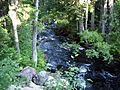
Breitenbush River north of Detroit
|
|
| Country | United States |
| State | Oregon |
| Region | Mount Jefferson Wilderness, Willamette National Forest |
| Physical characteristics | |
| Main source | junction of North and South forks Marion County, Mount Jefferson Wilderness, Oregon, United States 686 m (2,251 ft) 44°46′48″N 121°57′53″W / 44.78000°N 121.96472°W |
| River mouth | North Santiam River 515 m (1,690 ft) 44°44′57″N 122°8′2″W / 44.74917°N 122.13389°W |
| Length | 18.1 km (11.2 mi) |
| Basin features | |
| Basin size | 108 sq mi (280 km2) |
The Breitenbush River is a river in western Oregon, United States. It flows into the North Santiam River. The Breitenbush River helps drain a wild, forest-covered area. This area is part of the Cascade Range, located east of Salem.
Contents
Exploring the Breitenbush River
The Breitenbush River starts high up in the Cascade Range. It begins in the Mount Jefferson Wilderness area. This wilderness is in the eastern part of Marion County.
Where the River Begins
The river has two main parts, called forks: the South Fork and the North Fork.
- The South Fork Breitenbush River starts from small streams. These streams flow out of Bays Lake and Russell Lake. These lakes are found in a beautiful area called Jefferson Park. This is high up, about 6,000 feet (1,800 m) above sea level. The South Fork then flows towards the west-northwest. It joins with other smaller streams along the way.
- The North Fork Breitenbush River begins at Breitenbush Lake. Most of this lake is on the Warm Springs Indian Reservation. This fork also connects with another stream that flows past Pyramid Lake. It travels west-northwest, picking up water from many other creeks. Then it turns southwest near Bald Butte.
How the Forks Join
The North and South forks flow separately for a while. They finally meet about 0.25 miles (400 m) east of a small town called Breitenbush. After they join, the river flows mostly west-southwest. It travels through the beautiful Willamette National Forest.
Where the River Ends
The Breitenbush River eventually flows into the North Santiam River. This meeting point is near the town of Detroit. The last 2 miles (3.2 km) of the Breitenbush River now forms part of Detroit Lake. This lake was created by the Detroit Dam on the North Santiam River. During winter, when the lake's water level is low, you can see the original riverbed.
Images for kids
-
View of tributary from road to Breitenbush Lake of North Fork Of North Fork of Breitenbush River
-
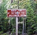
Weathered road sign naming North Fork of North Fork Breitenbush River
-
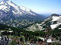
Jefferson Park at the foot of Mount Jefferson, headwaters of the South Fork of the Breitenbush River
-
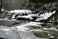
View of river from Breitenbush Hot Springs


