Brentwood, Missouri facts for kids
Quick facts for kids
Brentwood, Missouri
|
|
|---|---|

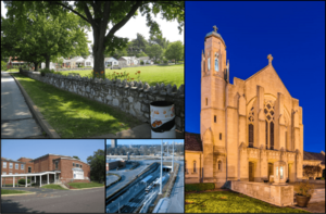
Top left: Neighborhood near Mark Twain Elementary School; Right: St. Mary Magdalen Catholic Church; Bottom left: Brentwood High School; Bottom middle: Brentwood I-64 station
|
|

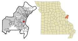
Location of Brentwood, Missouri
|
|
| Country | United States |
| State | Missouri |
| County | St. Louis |
| Area | |
| • Total | 1.95 sq mi (5.06 km2) |
| • Land | 1.95 sq mi (5.06 km2) |
| • Water | 0.00 sq mi (0.00 km2) |
| Elevation | 492 ft (150 m) |
| Population | |
| • Total | 8,233 |
| • Density | 4,215.57/sq mi (1,627.48/km2) |
| Time zone | UTC-6 (Central (CST)) |
| • Summer (DST) | UTC-5 (CDT) |
| ZIP code |
63144
|
| Area code(s) | 314 |
| FIPS code | 29-08236 |
| GNIS feature ID | 2393411 |
| Website | City of Brentwood official website: http://www.brentwoodmo.org |
Brentwood is a city in St. Louis County, Missouri, USA. It's like a close-by neighborhood of the bigger city of St. Louis. In 2020, about 8,233 people lived here.
Contents
Geography
Brentwood is a small city, covering about 1.96 square miles (5.06 square kilometers) of land. That's about the size of 1,250 football fields! It's all land, with no big lakes or rivers inside the city.
History
The area that is now Brentwood was first settled through three land purchases. These happened in the early 1800s. One of the first people to buy land was Louis J. Bompart in 1804.
In the 1870s, a man named Thomas Madden moved to the area. He became a very important businessman. He ran a rock quarry and opened several shops. These included a tavern, a barbershop, a grocery store, and a blacksmith shop. Because of Mr. Madden's importance, the town was first named Maddenville.
Maddenville was located on the Manchester Trail. This was a busy route for mail coaches and prairie schooners heading west. This helped Maddenville grow into a busy town outside of St. Louis. A streetcar line also connected it to St. Louis.
In 1919, people in Maddenville found out that the nearby town of Maplewood was planning to take over their town. To stop this and to create their own school district, the residents decided to form their own village. On December 15, 1919, Maddenville officially became the village of Brentwood.
During the late 1920s, Brentwood faced some challenges. There were many places where illegal activities took place, especially near Manchester Road and Brentwood Boulevard. James L. Willingham became the first mayor in 1929. He promised to clean up Brentwood and remove the illegal businesses. He succeeded in doing this. The town then became a safe and attractive place for families again. On April 12, 1929, Mayor Willingham signed a new law. This law officially made Brentwood a city and set its borders.
Population Facts
Here's how Brentwood's population has changed over the years:
| Historical population | |||
|---|---|---|---|
| Census | Pop. | %± | |
| 1930 | 2,819 | — | |
| 1940 | 4,383 | 55.5% | |
| 1950 | 7,504 | 71.2% | |
| 1960 | 12,250 | 63.2% | |
| 1970 | 11,248 | −8.2% | |
| 1980 | 8,209 | −27.0% | |
| 1990 | 8,150 | −0.7% | |
| 2000 | 7,693 | −5.6% | |
| 2010 | 8,055 | 4.7% | |
| 2020 | 8,233 | 2.2% | |
| U.S. Decennial Census | |||
2020 Population Details
In 2020, the city had 8,233 people living in it. There were 4,044 households. A household is a group of people living together. About 19.5% of these households had children under 18.
The population included people of many different backgrounds. About 82% were white, 4% were black or African-American, and 6% were Asian. About 3% of the population was Hispanic or Latino.
The average age in Brentwood was about 36.4 years old. About 17% of the people were under 18. About 15% were 65 years old or older.
Getting Around
Public Transportation
Brentwood has public transportation options. The Blue Line of the St. Louis light rail system serves the city. There is one station called Brentwood I-64.
The city also has the Brentwood Transit Center. This center connects the light rail station with MetroBus routes. It also offers special services for people who need extra help getting around.
Main Roads
Several important roads run through Brentwood. These include Brentwood Boulevard, Hanley Road, and Manchester Road. Major highways like Interstate 64 and Interstate 170 are also very close by.
Education
The Brentwood School District runs the schools in the city. There are two elementary schools and one middle school. Students then go on to Brentwood High School.
The city also has its own public library. It's called the Brentwood Public Library. It's a great place to find books and learn new things.
See also
 In Spanish: Brentwood (Misuri) para niños
 | May Edward Chinn |
 | Rebecca Cole |
 | Alexa Canady |
 | Dorothy Lavinia Brown |

