Bridgeport, Oklahoma facts for kids
Quick facts for kids
Bridgeport, Oklahoma
|
|
|---|---|

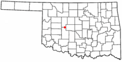
Location of Bridgeport, Oklahoma
|
|
| Country | United States |
| State | Oklahoma |
| County | Caddo |
| Area | |
| • Total | 0.54 sq mi (1.39 km2) |
| • Land | 0.54 sq mi (1.39 km2) |
| • Water | 0.00 sq mi (0.00 km2) |
| Elevation | 1,490 ft (450 m) |
| Population
(2020)
|
|
| • Total | 97 |
| • Density | 180.63/sq mi (69.75/km2) |
| Time zone | UTC-6 (Central (CST)) |
| • Summer (DST) | UTC-5 (CDT) |
| FIPS code | 40-08750 |
| GNIS feature ID | 2409906 |
Bridgeport is a small town located in Caddo County, Oklahoma, in the United States. In 2020, about 97 people lived there. It is known for its historical connection to a bridge over the Canadian River.
Contents
History of Bridgeport
Bridgeport got its name because of a special bridge. There used to be a toll bridge over the Canadian River at this spot. A toll bridge is one where people pay a small fee to cross.
Geography of Bridgeport
Bridgeport is located on the northern edge of Caddo County. It shares a border with Blaine County to the north. The town sits on the south side of the Canadian River valley, looking over its wide floodplain.
Roads and Highways
The old U.S. Route 66 is about half a mile south of town. Interstate 40 runs another half mile further south. The closest way to get onto Interstate 40 is about 2 miles east at Exit 101. Downtown Oklahoma City is about 52 miles east of Bridgeport.
Town Size
According to the United States Census Bureau, Bridgeport covers a total area of about 1.4 square kilometers (0.54 square miles). All of this area is land.
Population of Bridgeport
| Historical population | |||
|---|---|---|---|
| Census | Pop. | %± | |
| 1910 | 428 | — | |
| 1920 | 294 | −31.3% | |
| 1930 | 432 | 46.9% | |
| 1940 | 302 | −30.1% | |
| 1950 | 199 | −34.1% | |
| 1960 | 139 | −30.2% | |
| 1970 | 142 | 2.2% | |
| 1980 | 115 | −19.0% | |
| 1990 | 137 | 19.1% | |
| 2000 | 109 | −20.4% | |
| 2010 | 116 | 6.4% | |
| 2020 | 97 | −16.4% | |
| U.S. Decennial Census | |||
In 2000, there were 109 people living in Bridgeport. These people made up 42 households and 30 families. The population density was about 203.7 people per square mile. There were 46 homes in the town.
About 28.6% of households had children under 18 living with them. About 47.6% were married couples. The average household had 2.60 people, and the average family had 3.10 people.
The population was spread out by age. About 24.8% were under 18 years old. About 17.4% were 65 years or older. The average age in Bridgeport was 38 years.
Transportation in Bridgeport
Bridgeport is located just north of the historic US Route 66. It is also north of the modern Interstate 40.
Air Travel
The town is served by Hinton Municipal Airport. This airport is about 5 miles southeast of Bridgeport. It has a paved runway that is 4001 feet long. For bigger flights, Will Rogers World Airport is about 58 miles to the east-southeast.
Railroad
Bridgeport has its own 9.6-mile branch of the AT&L Railroad. This line connects to Geary, Oklahoma, and then to El Reno, Oklahoma. From El Reno, the AT&L uses Union Pacific tracks to reach Oklahoma City. This railroad helps transport things like grain, fertilizer, and other farm products.
See also
 In Spanish: Bridgeport (Oklahoma) para niños

