Bridgewater (CDP), New York facts for kids
Quick facts for kids
Bridgewater, New York
|
|
|---|---|

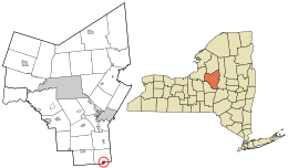
Location in Oneida County and the state of New York.
|
|
| Country | United States |
| State | New York |
| County | Oneida |
| Town | Bridgewater |
| Incorporated | April 21, 1825 |
| Dissolved | December 31, 2014 |
| Area | |
| • Total | 0.97 sq mi (2.52 km2) |
| • Land | 0.97 sq mi (2.52 km2) |
| • Water | 0.00 sq mi (0.00 km2) |
| Elevation | 1,211 ft (369 m) |
| Population
(2020)
|
|
| • Total | 516 |
| • Density | 531.41/sq mi (205.09/km2) |
| Time zone | UTC-5 (Eastern (EST)) |
| • Summer (DST) | UTC-4 (EDT) |
| ZIP code |
13313
|
| Area code(s) | 315 |
| FIPS code | 36-08169 |
| GNIS feature ID | 2391559 |
Bridgewater is a small community known as a hamlet in Oneida County, New York. In 2010, about 470 people lived there. By 2020, the population grew to 516.
This hamlet is part of the larger Town of Bridgewater. It is located where two important roads meet: U.S. Route 20 and N.Y. Route 8. For many years, from 1825 until 2014, Bridgewater was an official village.
Contents
History of Bridgewater
Early Days and Railways
Bridgewater officially became a village in 1825. This meant it had its own local government. A railway called the Unadilla Valley Railway used to end in Bridgewater. It connected to another railway line, the Delaware, Lackawanna and Western Railroad, which helped people and goods travel.
Historic Buildings in Bridgewater
Some buildings in Bridgewater are very old and important. The Brick Store Building and the Bridgewater Railroad Station are two of these. They are listed on the National Register of Historic Places, which means they are special places that should be protected.
Village Dissolution
On March 18, 2014, the people of Bridgewater voted on an important decision. They decided to stop being an official village. The vote was 40 to 8 in favor of this change. So, on December 31, 2014, Bridgewater stopped being a village. Starting January 1, 2015, the larger Town of Bridgewater took over running the area.
Geography of Bridgewater
Where is Bridgewater Located?
Bridgewater is located at coordinates 42°52.8′N 75°15.0′W / 42.8800°N 75.2500°W. This helps us find its exact spot on a map.
Size and Surroundings
According to the United States Census Bureau, Bridgewater covers about 0.6 square miles (1.6 square kilometers). All of this area is land. The hamlet is also very close to the borders of two other counties: Madison County and Otsego County.
Major Roads in Bridgewater
Bridgewater is easy to find because it sits right at the crossing of U.S. Route 20 and NY 8. These are important roads that connect Bridgewater to other towns and cities.
Population Changes in Bridgewater
| Historical population | |||
|---|---|---|---|
| Census | Pop. | %± | |
| 1840 | 350 | — | |
| 1860 | 306 | — | |
| 1870 | 230 | −24.8% | |
| 1880 | 224 | −2.6% | |
| 1900 | 269 | — | |
| 1910 | 245 | −8.9% | |
| 1920 | 232 | −5.3% | |
| 1930 | 228 | −1.7% | |
| 1940 | 238 | 4.4% | |
| 1950 | 309 | 29.8% | |
| 1960 | 373 | 20.7% | |
| 1970 | 601 | 61.1% | |
| 1980 | 578 | −3.8% | |
| 1990 | 537 | −7.1% | |
| 2000 | 579 | 7.8% | |
| 2010 | 470 | −18.8% | |
| 2020 | 516 | 9.8% | |
| U.S. Decennial Census | |||
The population of Bridgewater has changed over many years. In 1840, there were about 350 people. The population went up and down over time. By 1970, it reached its highest point with 601 people. In 2010, there were 470 people, and by 2020, the population grew to 516.
In 2000, when Bridgewater was still a village, there were 579 people living there. Most households were families, and many had children under 18. The average age of people living in Bridgewater was 31 years old.
Notable Person
- Asher Tyler – He was a U.S. Congressman who came from Bridgewater.
See also
 In Spanish: Bridgewater (villa) para niños
 | Bayard Rustin |
 | Jeannette Carter |
 | Jeremiah A. Brown |

