Brier Knob (Avery County, North Carolina) facts for kids
Quick facts for kids Brier Knob |
|
|---|---|

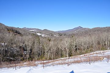
Brier Knob (center), also Sugar Mountain and Flattop Mountain on left, Grandfather Mountain and Pixie Mountain on right.
|
|
| Highest point | |
| Elevation | 4,085 ft (1,245 m) |
| Geography | |
| Location | Avery County, North Carolina, U.S. |
| Parent range | Blue Ridge Mountains |
| Topo map | USGS Grandfather Mountain |
Brier Knob is a mountain located in the beautiful North Carolina High Country. It stands near the community of Linville. This mountain is entirely within the Pisgah National Forest, a large protected area. Brier Knob reaches a height of about 4,085 feet (1,245 meters). Water from the mountain flows into the Linville River.
What is Brier Knob?
Brier Knob is a natural landmark in the mountains of North Carolina. It is known for being the northern edge of the Linville area. Unlike some nearby mountains, Brier Knob does not have buildings or developments on its top. This helps keep the mountain wild and natural.
Where is Brier Knob Located?
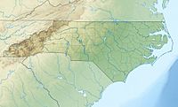
This mountain is found in Avery County, North Carolina. It is part of the larger Blue Ridge Mountains range. To the east, you'll find NC 105. West Fork Road runs along its western side. Its location makes it a key part of the local landscape.
Nature and Environment
Being part of the Pisgah National Forest means Brier Knob is a protected area. This forest is home to many types of plants and animals. The streams that start on Brier Knob feed into the Linville River. This river is important for the local ecosystem. The lack of development on the mountain's summit helps preserve its natural beauty.
 | Sharif Bey |
 | Hale Woodruff |
 | Richmond Barthé |
 | Purvis Young |


