
Brion Island facts for kids
|
Île Brion
|
|
|---|---|

Map of Brion Island
|
|

Brion Island
Location in Quebec
Location of Brion Island in Quebec
|
|
| Geography | |
| Location | Gulf of Saint Lawrence |
| Coordinates | 47°47′34″N 61°28′05″W / 47.79278°N 61.46806°W |
| Archipelago | Magdalen Islands |
| Area | 6.5 km2 (2.5 sq mi) |
| Length | 8 km (5 mi) |
| Administration | |
| Province | Quebec |
| Region | Gaspésie–Îles-de-la-Madeleine |
| Municipality | Grosse-Île, Quebec |
Brion Island (French: Île Brion) is a small, empty island located in the middle of the Gulf of Saint Lawrence. It is part of the Magdalen Islands group in Quebec, Canada. This island is the most northeastern part of the Magdalen archipelago. Only the Bird Rocks (Rochers aux Oiseaux), which are about 20 kilometers (12 miles) further east, are more distant.
Contents
A Glimpse into Brion Island's Past
How Brion Island Got Its Name
In 1534, a famous explorer named Jacques Cartier sailed past this island. He placed his second cross here, marking his journey. Cartier decided to name the island ille de Bryon. He did this to honor his main supporter for the expedition, Philippe de Chabot. Philippe de Chabot was also known as the Seigneur de Brion and was an important Admiral of France.
Exploring Brion Island's Geography
Key Features of the Island
On the southeast coast of Brion Island, you can find a notable spot called Haldimand Cliff (Falaise Haldimand). This cliff was named after Frederick Haldimand, a historical figure.
Discovering Brion Island's Nature
Protecting the Island's Wildlife
Most of Brion Island is a special protected area called the Réserve écologique de l'Île-Brion. This means the island's plants and animals are kept safe. To the northwest of Brion Island, there are several smaller islands known as the Bird Rocks. These rocks are part of a Federal Migratory Bird Sanctuary. This sanctuary helps protect many different kinds of birds that migrate through the area.
Images for kids
-
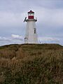
A view of Brion Island's coast.
-
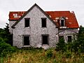
Another perspective of Brion Island.
-
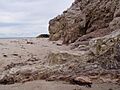
The natural beauty of Brion Island.


See also
 In Spanish: Isla Brion para niños
