Broadmoor, New Orleans facts for kids
Quick facts for kids
Broadmoor
|
|
|---|---|
|
New Orleans Neighborhood
|
|

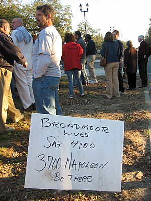
Broadmoor Lives! Post Katrina rally
|
|
| Country | United States |
| State | Louisiana |
| City | New Orleans |
| Planning District | District 3, Uptown/Carrollton |
| Area | |
| • Total | 0.56 sq mi (1.5 km2) |
| • Land | 0.56 sq mi (1.5 km2) |
| • Water | 0.00 sq mi (0 km2) |
| Elevation | 2 ft (0.6 m) |
| Population
(2010)
|
|
| • Total | 2,378 |
| • Density | 4,250/sq mi (1,640/km2) |
| Time zone | UTC-6 (CST) |
| • Summer (DST) | UTC-5 (CDT) |
| Area code(s) | 504 |
|
Broadmoor Historic District
|
|
| Location | Roughly bounded by South Broad/Fountainebleau, Milan, S. Claiborne and Octavia, New Orleans, Louisiana Roughly bounded by Walmsley, S. White, Eden, and S. Jefferson Davis Pkwy, (increase) New Orleans, Louisiana |
|---|---|
| Architectural style | Bungalow/Craftsman, Colonial Revival, et al. (original) Colonial Revival, Bungalow/Craftsman (increase) |
| NRHP reference No. | 03000519 and 07000940 |
| Added to NRHP | June 13, 2003 (original) September 13, 2007 (increase) |
Broadmoor is a lively neighborhood in the city of New Orleans. It's part of the Uptown/Carrollton area. Broadmoor is known for its strong community spirit, especially after facing big challenges like floods. It even has a special part called the Broadmoor Historic District, recognized for its important history.
Contents
Broadmoor's History
Broadmoor is in a low-lying part of New Orleans. It was mostly a large marsh, a wet, grassy area, where people used to go fishing. The neighborhood only really started to grow in the early 1900s. This happened after better drainage systems were put in place.
Early Development and Growth
The first drainage canals were built in 1885. A pumping station, which helps remove water, opened in Broadmoor in 1903. Even more powerful pumps were added in 1915. After this, more people began to settle in the area.
During the 1920s, Broadmoor's population grew a lot. Over a third of the houses and the first public school, Wilson School, were built then. This growth continued for many years. However, in the late 1950s and 1960s, many families moved to suburbs. This caused Broadmoor's population to shrink for a while.
Facing Floods and Rebuilding
Broadmoor was hit hard by a flood in 1995. After that, the drainage systems were greatly improved. But the neighborhood faced an even bigger challenge in 2005. This was after Hurricane Katrina.
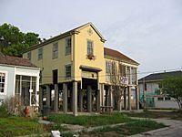
After Katrina, a report suggested turning Broadmoor into park land. But the residents strongly disagreed with this idea. Hundreds of families were already back in their homes by early 2006. Many lived upstairs while fixing their flooded ground floors. Their strong community spirit helped them rebuild.
Broadmoor's Location
Broadmoor is located at 29°56′56″N 90°06′15″W / 29.94889°N 90.10417°W. It sits about 2 feet (0.6 meters) above sea level. The neighborhood covers about 0.56 square miles (1.45 square kilometers) of land.
It is close to some of New Orleans' wealthier areas. These include Uptown and the Garden District. Broadmoor is also near Claiborne Avenue. This is a main road connecting Downtown New Orleans to Jefferson Parish.
Neighboring Areas
Broadmoor shares its borders with several other neighborhoods:
- Gert Town (to the north)
- Central City (to the east)
- Milan (to the south)
- Freret (to the south)
- Marlyville/Fontainebleau (to the west)
Neighborhood Borders
The city defines Broadmoor's exact borders using these streets:
- Eve Street
- Washington Avenue
- Toledano Street
- South Claiborne Avenue
- Jefferson Avenue
- South Rocheblave Street
- Nashville Avenue
- Octavia Street
Broadmoor's People
In 2000, about 7,232 people lived in Broadmoor. The neighborhood was very diverse. About 68.2% of residents were African American, and 25.8% were White.
By 2010, the population was about 5,381 people. The neighborhood remained diverse. About 61.1% of residents were African American, and 28.8% were White. These numbers show how the community has changed over time.
Learning in Broadmoor
Broadmoor has a strong focus on education. It is home to schools and a community library.
Schools in Broadmoor
Public schools in Broadmoor are managed by the Orleans Parish School Board (OPSB) and the Recovery School District (RSD).
Andrew Wilson Elementary School is in Broadmoor. It was built in 1922 and was the first public school in the area. Before Hurricane Katrina, the school building was not in the best shape. The flood from Katrina damaged the lower part of the school.
After the hurricane, the building was left empty for months. Some city leaders thought about tearing it down. But local activists, like LaToya Cantrell, fought to save and restore the school. They convinced different levels of government to fund a $30 million renovation. Wilson Elementary reopened in 2010. It became a modern, bright school with many eco-friendly features.
Public Libraries
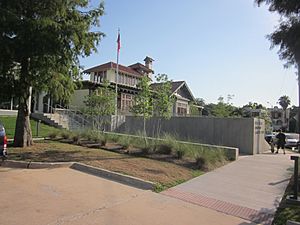
The Rosa F. Keller Library and Community Center is also in Broadmoor. It is part of the New Orleans Public Library system. This library was rebuilt after Hurricane Katrina. It had its grand reopening in March 2012.
The Keller site has a modern library building. It also includes the historic Hardie-Fattel house from 1918. This house is attached to the library and serves as a community center. The renovated house has classrooms, meeting rooms, a teaching kitchen, and a coffee shop. Outside, there is an outdoor reading garden and a terrace. The restoration was partly paid for by a grant from the Carnegie Corporation.
 | Jessica Watkins |
 | Robert Henry Lawrence Jr. |
 | Mae Jemison |
 | Sian Proctor |
 | Guion Bluford |


