
Brockway Mountain Drive facts for kids
Quick facts for kids
|
|
|---|---|
|
Brockway Mountain Drive highlighted in red
|
|
| Route information | |
| Maintained by the Keweenaw County Road Commission | |
| Length | 8.883 mi (14.296 km) |
| Existed | October 14, 1933–present |
| Restrictions | Closed to vehicular traffic in winter |
| Major junctions | |
| West end | |
| East end | |
| Location | |
| Counties: | Keweenaw |
| Highway system | |
| Michigan State Trunkline Highway System Interstate • US • State (CDH) |
|
|
Brockway Mountain Drive
|
|
| NRHP reference No. | 100001345 |
| Added to NRHP | July 24, 2017 |

Brockway Mountain Drive is a beautiful scenic road in Michigan's Upper Peninsula. It stretches for about 8.88 miles (14.3 kilometers). You can find it just west of Copper Harbor. This special road lets you drive along the top of Brockway Mountain.
The drive climbs very high, reaching 1,320 feet (402 meters) above sea level. This is about 720 feet (219 meters) higher than the surface of Lake Superior. Along the way, there are many spots to stop and enjoy amazing views. You can see Copper Harbor, Lake Superior, and thick forests. On a clear day, you might even spot Isle Royale, which is about 50 miles (80 kilometers) away!
Brockway Mountain was named after Daniel D. Brockway, an early settler in the area. The road itself was built in 1933. It was part of a program during the Great Depression to help people find work. Since it opened, Brockway Mountain Drive has been famous for its stunning views. It's often featured in articles about Michigan's beautiful places.
Contents
What is Brockway Mountain Drive Like?
This road is a great way to explore the area. You can start your journey from either Eagle Harbor or Copper Harbor. It forms a scenic loop off the main highway, M-26.
Starting Your Drive
If you begin from the west, near Lake Bailey, the road starts to climb. It follows the ridge of the Keweenaw Fault. As you drive, you'll see low stone walls. These walls were built when the road was first made. About 2.5 miles (4 kilometers) from the west end, there's a parking area. This is for the Oren Krumm Trail, which is part of the Brockway Mountain Audubon Sanctuary.

When you reach the top of the mountain, you'll see incredible panoramic views. You can look out over Lake Superior, Copper Harbor, Eagle Harbor, and the many lakes and forests around. Sometimes, you can even see large ships on Lake Superior. On very clear days, Isle Royale is visible far in the distance.
Driving Down the Mountain
As you continue eastward, the road gently descends towards Copper Harbor. The drive has many twists and turns. There are several viewpoints where you can pull over. These spots are perfect for taking photos and enjoying the scenery. Some viewpoints are right on the edge of the bluff, where the mountain drops sharply.
Near the eastern end, you'll find two sharp turns called hairpin turns. The first one has a great scenic overlook and a parking area. From here, you can see Copper Harbor and part of US Highway 41. After this, the road goes steeply down the mountain. It ends back at M-26 on the western edge of Copper Harbor.

Brockway Mountain Drive is one of the highest scenic roads in the United States. It's especially high for a road between the Rocky and Allegheny mountain ranges. In winter, the road closes to cars because it's not plowed. Instead, it becomes a popular trail for snowmobiles! About 200 vehicles use the road each day on average. There are no speed limits posted, but the road's design naturally encourages careful driving.
History of Brockway Mountain Drive
Brockway Mountain is a volcanic landform. It stands 1,320 feet (402 meters) tall on the Keweenaw Peninsula. The mountain was named after Daniel D. Brockway. He was a pioneer settler, postmaster, and state road commissioner. Brockway moved to Copper Harbor in 1846. He built the first permanent building there, a guesthouse for miners. By the time he passed away in 1899, the ridge west of town was named in his honor.

Building the Road
The idea for a road to the top of Brockway Mountain came from Warren H. Manning in the 1920s. He was a famous landscape architect. Construction began in early 1933. The Keweenaw County Road Commission built it. They used money from the federal government. This money was part of programs to help people find jobs during the Great Depression. Instead of just giving out aid, the government provided work.
Up to 300 workers were hired for the project. They earned 25 cents an hour. The road officially opened to the public on October 14, 1933. It cost about $30,000 to build at first. In 1934, more work was done to build the stone walls you see today. For a short time, the road was used as a temporary connection for the state highway, M-129 (now part of M-26).

The road was fully finished on June 14, 1935. Its total cost was around $40,000. It quickly became a very popular place for people to drive. By 1938, over a million people had driven on Brockway Mountain Drive! This helped tourism grow in the area. Parts of the road were paved in 1938 and 1940.

The first Skytop Inn was built at the mountain's summit in 1935. It was a gift shop and a place for visitors. A new building replaced it in 1965. In 2013, the land at the top of Brockway Mountain was bought by Eagle Harbor Township. They planned to turn the Skytop Inn into a visitor center. The summit area is now part of the Keweenaw Coastal Wildlife Corridor. This is a protected area important for birds during their yearly migration.
What Can You See and Do?
Brockway Mountain Drive offers many chances to enjoy nature.
Bird Watching
In the spring, especially in April, many hawks fly along the Keweenaw Peninsula. They gather along the cliffs and ridges of Brockway Mountain. This makes it a fantastic spot for bird watching!
Stargazing and Wildflowers
The top of the mountain can be windy, even in summer, so it's a good idea to bring a jacket. It's also known as an excellent place for stargazing. There are no city lights to block the view of the night sky.
The mountainsides around the drive are mostly private land, but they are open for people to enjoy. The Michigan Nature Association owns 200 acres (81 hectares) on Brockway Mountain. Over 700 types of flowers grow here, including beautiful trillium and orchids. The best time to see the flowers is in June. Some of these wildflowers are found nowhere else in Michigan!
Fall Colors
The area is also famous for its stunning fall colors. The leaves start to change by the second week of September and stay colorful through October. Many magazines and newspapers have praised Brockway Mountain Drive for its beauty.
Awards and Recognition
Brockway Mountain Drive has received many awards and been recognized in various publications for its beauty.

- In 1956, the Milwaukee Sentinel called it the "famous Brockway Mountain Drive."
- The New York Times in 1962 said it was a "side trip that should not be missed."
- The Chicago Tribune described the overlook as "breathtaking" in 1986.
- In 1990, the Chicago Sun-Times said its views "rivaled any in New England."
- Michigan Living magazine chose the route as "one of the best fall color views" in 1994 and 2001.
- Bicycling magazine named it the "most beautiful bike ride in the United States" in 1995.
- In 2007, NBC's Today featured Brockway Mountain Drive as a "great and unusual fall foliage destination."
- Local residents voted it the Upper Peninsula's "favorite natural wonder" in 2010.
- On July 24, 2017, Brockway Mountain Drive was added to the National Register of Historic Places. This means it's recognized as an important historical place in the United States.

Where Does the Road Start and End?


Brockway Mountain Drive connects to M-26 at both its western and eastern ends.
The entire road is in Keweenaw County.
| Location | mi | km | Destinations | Notes |
|---|---|---|---|---|
| Eagle Harbor Township | 0.000 | 0.000 | This is the western start of the drive. | |
| 4.920 | 7.918 | Parking area | This parking area is at the highest point of Brockway Mountain. | |
| Grant Township | 8.883 | 14.296 | This is the eastern end of the drive, near Copper Harbor. | |
| 1.000 mi = 1.609 km; 1.000 km = 0.621 mi | ||||
Images for kids
-
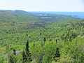
View to the west from Brockway Mountain, with Lakes Upson, Bailey, and Superior in the distance
See also
 In Spanish: Unidad de montañas de Brockway para niños
