Bronson, Iowa facts for kids
Quick facts for kids
Bronson, Iowa
|
|
|---|---|

Location of Bronson, Iowa
|
|
| Country | |
| State | |
| County | Woodbury |
| Area | |
| • Total | 0.35 sq mi (0.90 km2) |
| • Land | 0.35 sq mi (0.90 km2) |
| • Water | 0.00 sq mi (0.00 km2) |
| Elevation | 1,122 ft (342 m) |
| Population
(2020)
|
|
| • Total | 294 |
| • Density | 849.71/sq mi (327.72/km2) |
| Time zone | UTC-6 (Central (CST)) |
| • Summer (DST) | UTC-5 (CDT) |
| ZIP code |
51007
|
| Area code(s) | 712 |
| FIPS code | 19-08650 |
| GNIS feature ID | 0454840 |
Bronson is a small city in Woodbury County, Iowa, United States. It is part of the larger Sioux City metropolitan area. In 2020, the city had a population of 294 people.
Bronson celebrated its 100th birthday, also known as its centennial, in 2003. A special book was made to share some of the town's history during this celebration.
Contents
A Look Back at Bronson's History
Bronson was officially started in 1901. The city was named after an early settler in the area, a person named Ira D. Bronson.
Bronson's Location and Land
Bronson is located in Iowa at specific geographic coordinates: 42.409450 degrees North and 96.211564 degrees West.
According to the United States Census Bureau, the city covers a total area of about 0.31 square miles (0.80 square kilometers). All of this area is land, meaning there are no large bodies of water within the city limits.
Bronson is also found within a special land area called the Loess Hills. These hills are unique because they are made of fine, wind-blown soil.
Who Lives in Bronson?
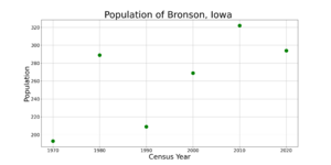
| Historical populations | ||
|---|---|---|
| Year | Pop. | ±% |
| 1970 | 193 | — |
| 1980 | 289 | +49.7% |
| 1990 | 209 | −27.7% |
| 2000 | 269 | +28.7% |
| 2010 | 322 | +19.7% |
| 2020 | 294 | −8.7% |
| Source: and Iowa Data Center Source: |
||
Population in 2020
In 2020, the United States census counted 294 people living in Bronson. There were 106 households, which are groups of people living together, and 75 families. The city had about 849 people per square mile (328 people per square kilometer).
Most of the people living in Bronson were White (about 90.8%). A small number of residents were Black or African American, Native American, or from two or more races. About 3.7% of the population identified as Hispanic or Latino.
Many households (45.3%) had children under 18 living with them. The average age of people in Bronson was 36.0 years. About 30.6% of residents were under 20 years old, showing a good number of young people. About 10.9% were 65 years old or older. Slightly more than half of the population (53.1%) was male.
Population in 2010
The census in 2010 showed that 322 people lived in Bronson. There were 113 households and 82 families. The population density was about 1039 people per square mile (401 people per square kilometer).
Most residents (97.8%) were White. About 1.2% of the population was Hispanic or Latino.
About 42.5% of households had children under 18. The average age in the city was 33 years. Many residents (32.9%) were under 18 years old. About 9.6% were 65 years old or older. The number of males and females was almost equal.
Schools in Bronson
The Lawton–Bronson Community School District is in charge of the public schools in Bronson. This school district was created on July 1, 1966. It was formed when the Lawton and Bronson districts joined together. The Bronson district used to only have elementary schools before the merger.
See also
 In Spanish: Bronson (Iowa) para niños
 | William L. Dawson |
 | W. E. B. Du Bois |
 | Harry Belafonte |


