Brookfield Center, Connecticut facts for kids
Quick facts for kids
Brookfield Center, Connecticut
|
|
|---|---|

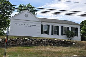
Town office building in Brookfield Center
|
|

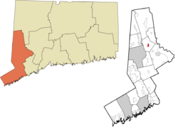
Location within the Western Connecticut Planning Region and the state of Connecticut
|
|
| Country | |
| State | Connecticut |
| County | Fairfield |
| Town | Brookfield |
| Area | |
| • Total | 1.32 km2 (0.51 sq mi) |
| • Land | 1.32 km2 (0.51 sq mi) |
| • Water | 0.0 km2 (0 sq mi) |
| Elevation | 151 m (495 ft) |
| Time zone | UTC-5 (Eastern (EST)) |
| • Summer (DST) | UTC-4 (EDT) |
| ZIP Code |
06804 (Brookfield)
|
| Area code(s) | 203/475 |
| FIPS code | 09-08910 |
| GNIS feature ID | 2805933 |
Brookfield Center is a special kind of place in the town of Brookfield, located in Fairfield County, Connecticut, United States. It's called a census-designated place (CDP). This means it's an area that the U.S. Census Bureau defines for gathering population data, but it's not an officially incorporated town or city with its own local government.
Brookfield Center is known for its historic area. This includes the 43-acre (17 ha) Brookfield Center Historic District. This district is found around where two main roads, Route 25 and Route 133, meet. The area also includes the homes and neighborhoods nearby.
What is a Census-Designated Place?
A census-designated place, or CDP, is like a neighborhood or community that doesn't have its own separate town government. The U.S. Census Bureau creates these areas to collect information about people living there. This helps them understand population changes and how communities are growing. Brookfield Center was first officially listed as a CDP before the 2020 census.
Exploring the Historic District
The Brookfield Center Historic District is a special part of the community. It's a place where many old buildings and landmarks are preserved. These buildings often show what life was like in the past. Walking through a historic district can feel like stepping back in time. It helps people learn about the history and culture of the area.
 | William M. Jackson |
 | Juan E. Gilbert |
 | Neil deGrasse Tyson |


