Brookport, Illinois facts for kids
Quick facts for kids
Brookport, Illinois
|
|
|---|---|

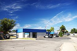
City Hall
|
|

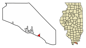
Location in Massac County, Illinois
|
|
| Country | United States |
| State | Illinois |
| County | Massac |
| Area | |
| • Total | 0.66 sq mi (1.71 km2) |
| • Land | 0.65 sq mi (1.69 km2) |
| • Water | 0.01 sq mi (0.02 km2) |
| Elevation | 340 ft (100 m) |
| Population
(2020)
|
|
| • Total | 725 |
| • Density | 1,110.26/sq mi (428.77/km2) |
| Time zone | UTC-6 (CST) |
| • Summer (DST) | UTC-5 (CDT) |
| ZIP Code |
62910
|
| Area code(s) | 618 |
| FIPS code | 17-08706 |
| Wikimedia Commons | Brookport, Illinois |
Brookport is a city located in Massac County, Illinois, in the United States. In 2020, about 725 people lived there. This was a decrease from 984 people in 2010. Brookport is part of the larger area around Paducah, Kentucky.
History of Brookport
Brookport was started by Charles Pell in 1855. It was first called "Pellonia," named after him. The small city faced challenges for a few years. However, things improved when the Illinois Central Railroad was built nearby in the late 1880s.
In 1888, the city was officially renamed "Brooklyn." Later, in 1901, its name was changed to "Brookport." This new name combines "Brooklyn" with "port," because it is a port city on the river.
Geography of Brookport
Brookport is in the southeastern part of Massac County. It sits on the north bank of the Ohio River. Right across the river is Paducah, Kentucky.
U.S. Route 45 goes through Brookport. This road connects the city to Paducah across the river. It also leads to Interstate 24 near Metropolis to the northwest.
The Brookport Bridge carries U.S. Route 45 over the Ohio River. This bridge is also known as the "Irvin S. Cobb Bridge." It is named after author Irvin S. Cobb, who was born in Paducah. The bridge was finished in 1929 and has two lanes.
The United States Army Corps of Engineers used to operate a lock and dam system on the Ohio River. This was about one mile downstream from Brookport.
According to the U.S. Census Bureau, Brookport covers about 0.66 square miles (1.71 square kilometers) of land. Only a very small part, about 0.01 square miles (0.02 square kilometers), is water.
Population Facts
| Historical population | |||
|---|---|---|---|
| Census | Pop. | %± | |
| 1870 | 104 | — | |
| 1890 | 216 | — | |
| 1900 | 865 | 300.5% | |
| 1910 | 1,443 | 66.8% | |
| 1920 | 1,098 | −23.9% | |
| 1930 | 1,336 | 21.7% | |
| 1940 | 1,247 | −6.7% | |
| 1950 | 1,119 | −10.3% | |
| 1960 | 1,154 | 3.1% | |
| 1970 | 1,046 | −9.4% | |
| 1980 | 1,128 | 7.8% | |
| 1990 | 1,070 | −5.1% | |
| 2000 | 1,054 | −1.5% | |
| 2010 | 984 | −6.6% | |
| 2020 | 725 | −26.3% | |
| U.S. Decennial Census | |||
The table above shows how Brookport's population has changed over the years. In 2000, there were 1,054 people living in the city. The population density was about 1,322 people per square mile.
The people living in Brookport in 2000 were of different age groups. About 28.1% were under 18 years old. About 15.6% were 65 years old or older. The average age in the city was 35 years.
See also
 In Spanish: Brookport (Illinois) para niños
 | James Van Der Zee |
 | Alma Thomas |
 | Ellis Wilson |
 | Margaret Taylor-Burroughs |


