
Adelaide Park Lands facts for kids
.jpg)


The Adelaide Park Lands are a special green area that wraps around the City of Adelaide in South Australia. They separate the city centre from the suburbs. This unique design was created by Colonel William Light in 1837 when he planned the city.
Originally, the Park Lands covered about 2,300 acres (around 930 hectares). Over time, some parts have been used for other things, like government buildings. However, a large portion remains as public green space.
Since 1852, the Adelaide City Council has looked after most of the Park Lands. In 2007, the Adelaide Park Lands Authority was created to help advise on their care. In 2008, the Adelaide Park Lands were added to the Australian National Heritage List. This means they are recognised as an important national treasure.
Contents
- History of the Park Lands
- The Park Lands Today
- The Numbered Parks
- Park 1: Possum Park / Pirltawardli
- Park 2: Denise Norton Park / Pardipardinyilla
- Park 6: Lefevre Park / Nantu Wama
- Park 11: Mistletoe Park / Tainmuntilla
- Park 19: Pelzer Park / Pityarilla
- Park 20: Blue Gum Park / Kurangga
- Park 21W: Golden Wattle Park / Mirnu Wirra
- Park 26: Adelaide Oval / Tarntanya Wama
- Park 27: Bonython Park / Tulya Wardli
- Protecting the Park Lands
- Images for kids
History of the Park Lands
Adelaide was one of the first planned cities in Australia, and the Park Lands were a key part of its original design. Colonel William Light chose a site that stretched across the River Torrens, which the local Kaurna people called Yatala. He wanted the city to fit naturally into the landscape.
In 1837, Light suggested that a large area of open space, which he called "Adelaide Park," should be kept as public park grounds. This included land both south and north of the River Torrens, plus several city squares like Victoria Square.
The design of Adelaide, with its grid pattern and central squares, was inspired by older city plans, including some from ancient Greece and Spanish colonial cities. However, there's no record that Light directly copied any specific plan.
By 1839, the Park Lands faced challenges like tree cutting, rubbish dumping, and grazing animals. To protect them, a group of park rangers was set up. Since 1852, the Adelaide City Council has managed these areas for public use.
In the late 1800s, animals like the Greater Bilby were still common in the Park Lands. The area known as Pinky Flat is thought to be named after the bilby, which was locally called "pinky." Sadly, bilbies are now extinct in the wild in South Australia.
Over the years, parts of the Park Lands were developed for important places like the Adelaide Botanic Garden, the Adelaide Oval, and the Victoria Park Racecourse. To make the Park Lands more beautiful, a plan was created in 1880 by John Ednie Brown. Much of this plan was put into action in the early 1900s, with many trees and gardens being added.
In 2007, the city centre and Park Lands were officially given National Heritage status. This recognised their importance as a unique example of early colonial planning that has kept its original layout for over 170 years.
The Park Lands Today
Today, about a quarter of the Park Lands are home to government, public, and cultural buildings. The remaining 700 hectares (about 1,730 acres) have been shaped into beautiful gardens and sports fields. Some areas are also kept as natural grasslands or woodlands, providing homes for native animals and plants.
In the early 2000s, there were plans to build a large grandstand in Victoria Park for events like the Clipsal 500 car race. However, many local groups and residents protested, and the plan was eventually stopped. This showed how much people care about protecting the Park Lands.
In 2006, the state government passed the Adelaide Park Lands Act 2005. This law helps protect the Park Lands and set up the Adelaide Park Lands Authority. In 2011, a large area of land (5.5 hectares) that used to be a water depot was returned to the Park Lands. It was planted with over 23,000 native trees and shrubs, creating an "urban forest."
The Numbered Parks

The Adelaide Park Lands are treated as a single park, but for easier management, the Adelaide City Council has divided them into 29 smaller areas. These are called "Park 1" to "Park 29." The numbering starts in the north and goes clockwise around the city.
Many of these parks also have special names, like Rymill Park. Since 1997, the City Council has been working to give the parks and city squares dual names, using both English and Kaurna names. The Kaurna are the traditional owners of the land where Adelaide is built. This project helps recognise the Kaurna culture and language. Signs with both names were put up in 2004. For example, Victoria Square is also known as Tarntanyangga, and the River Torrens is also called Karrawirra Parri.
Park 1: Possum Park / Pirltawardli
Pirltawardli means "possum place" in Kaurna. This large park (76 hectares) wraps around the western side of North Adelaide. It includes the Adelaide Golf Links.
This park is very important for the history of the Kaurna people and their language. In the early days of the colony, a "Native Location" was set up here. Missionaries like Christian Teichelmann and Clamor Schürmann lived here and studied the Kaurna language, even opening a school that taught in Kaurna. Their work helped record much of the Kaurna language and culture, which is now helping to bring the language back to life today.
Park 2: Denise Norton Park / Pardipardinyilla
Pardipardinyilla means "swimming place." This park is named after Denise Norton, a famous South Australian swimmer. It's about 17 hectares and is home to the Adelaide Aquatic Centre, where you can go swimming. It also has picnic areas, a playground called Bush Magic, and sports fields for cricket and tennis. The Bush Magic Play Park was special because it was one of the first playgrounds in South Australia to be accessible for wheelchairs.
Park 6: Lefevre Park / Nantu Wama
Nantu Wama means "horse plain" or "male grey kangaroo plain." This park is mainly used for keeping horses, with several paddocks and feeding yards. It's a unique place where you can still see horses grazing in the city. The park also has a playground, BBQ facilities, and sports fields used by schools.
Park 11: Mistletoe Park / Tainmuntilla
Tainmuntilla means "mistletoe place." This is a very large park that contains many well-known places. It's bordered by the River Torrens to the north and North Terrace to the south. Inside this park, you'll find the Adelaide Zoo, the Adelaide Botanic Garden, the Botanic Park, and the National Wine Centre. It also includes the old Royal Adelaide Hospital site and several university buildings.
Park 19: Pelzer Park / Pityarilla
Pityarilla means "marshmallow root place." This large triangular park is named after August Pelzer, Adelaide’s city gardener from 1899 to 1932. It has open spaces and playing fields. A popular spot here is The Marshmallow Park recreation hub, which is great for families and kids.
Park 20: Blue Gum Park / Kurangga
Kurrangga means "blue gum place." This park is 30.1 hectares and offers lots of activities. It has a boule/petanque area, various sports fields, and a mountain-bike / BMX-bike track. It's also home to one of the three Glover Playgrounds. You can find the TreeClimb adventure course here, which has high ropes for a fun challenge.
Park 21W: Golden Wattle Park / Mirnu Wirra
Mirnu Wirra means "golden wattle grove." This park is 31 hectares and features the Princess Elizabeth Playground, Lundie Gardens, and various sports fields. It's a great place for outdoor play and relaxation.
Park 26: Adelaide Oval / Tarntanya Wama
Tarntanya Wama means "Adelaide plain/oval." This park is famous for the Adelaide Oval, a major sports stadium. It's split by the River Torrens. The northern part includes the Adelaide Oval, Creswell Gardens, and Pinky Flat. The southern part contains important buildings like Parliament House, the Adelaide railway station, the Convention Centre, and the Festival Centre.
Park 27: Bonython Park / Tulya Wardli
Tulya Wardli means "Police barracks." This is a very large park (118 hectares) that includes Bonython Park itself, along with many other features. It's divided by railway lines and the River Torrens. You can find the Dame Roma Mitchell Gardens and the historic Old Adelaide Gaol here. There are also plans for new hospital buildings in parts of this park.
Protecting the Park Lands
Since Colonel William Light first planned the Park Lands in 1837, they were meant to be public open spaces forever. Because of this, any new buildings or developments in the Park Lands can cause debate.
Many people care deeply about protecting the Adelaide Park Lands. In 1987, the Adelaide Park Lands Preservation Association Inc. (APPA) was formed. This group works to protect the Park Lands from being used for purposes that go against their original design. They highlight issues like proposals for new buildings or events that might harm the natural environment or public access. For example, when there were plans for a permanent grandstand at Victoria Park for motor racing, the APPA and many community members spoke out, and the plans were eventually dropped. This shows the strong community support for keeping the Park Lands as green, open spaces for everyone to enjoy.
Images for kids
-
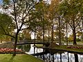
Rymill Park / Murlawirrapurka (Park 14), a popular part of the Park Lands.
-
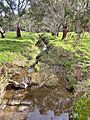
Gum trees and a creek in Adelaide's South Park Lands.
-
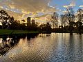
Rymill Park at sunset.


