Brynderwyn Range facts for kids
Quick facts for kids Brynderwyn Range |
|
|---|---|
| Brynderwyn Hills | |
The eastern end of the Brynderwyn Range as seen from Mangawhai Heads (October 2010)
|
|
| Highest point | |
| Elevation | 430 m (1,410 ft) |
| Naming | |
| Native name | [Piroa] Error: {{native name}}: unrecognized language tag: Māori (help) (language?) |
| Geography | |
| Geology | |
| Mountain type | Mountain range |
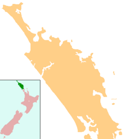
The Brynderwyn Range, also known as the Brynderwyn Hills, is a cool ridge of hills in northern New Zealand. It stretches from east to west across the Northland Peninsula. Imagine it like a long, green backbone! It's about 60 kilometers (37 miles) south of a city called Whangarei.
Contents
Exploring the Brynderwyn Range
Where are the Brynderwyn Hills?
These hills are found in the Northland Region of New Zealand. They start near Bream Bay on the eastern coast. From there, they reach all the way to the Otamatea River in the west. This river is actually an arm of the big Kaipara Harbour.
What makes the Brynderwyn Range special?
Even though the Brynderwyn Range isn't super tall, it's a very important part of Northland's landscape. The highest point is about 430 meters (1,410 feet) high. This is like climbing to the top of a really tall building!
One big reason these hills are famous is because State Highway 1 crosses them. This is a major road that goes through New Zealand. When you drive over the Brynderwyns, the road winds and turns a lot. It's a fun, twisty ride as it goes down towards the south.
What can you do there?
At the southern base of the hills, you'll find a small town called Brynderwyn. This is where State Highway 1 meets another important road, State Highway 12.
If you love walking, you're in luck! There are different walking tracks up to 10 kilometers (6 miles) long. From these tracks, you can see amazing views. You can look out towards the Whangarei Heads, Bream Bay, and even far out to sea. It's a great spot to enjoy nature and see some incredible New Zealand scenery.
 | Sharif Bey |
 | Hale Woodruff |
 | Richmond Barthé |
 | Purvis Young |


