Buccaneer Archipelago facts for kids
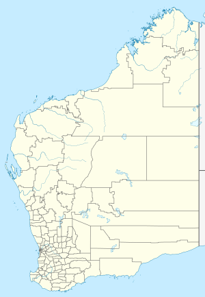
The Buccaneer Archipelago is a large group of islands located off the coast of Western Australia. You can find it near the town of Derby in a special area called the Kimberley region. The closest town where people live is Bardi, which is about 54 kilometers (34 miles) from the western edge of the islands.
As of 2020, there are plans to create a new marine park in this area. It will be called the Mayala Marine Park. This new park will help protect some of the islands in the Buccaneer group. It will be part of a bigger network of four marine parks, including the Lalang-gaddam Marine Park.
Contents
History of the Archipelago
Aboriginal Australians have lived in the Kimberley region for thousands of years. The traditional owners of the Buccaneer Archipelago are the Mayala people. This group includes the Yawijibaya and Unggarranggu peoples. The Bardi people also have traditional rights to fish and collect trochus shells in the area.
The archipelago got its name from an English explorer named William Dampier. He was a buccaneer, which means he was a type of pirate who was allowed to attack enemy ships. Dampier mapped this area in 1688. Later, in August 1821, Philip Parker King officially named the islands after him.
What is the Buccaneer Archipelago Like?
The Buccaneer Archipelago covers more than 50 square kilometers (19 square miles). It is located at the top of King Sound. The archipelago has about 800 islands! These islands are found between King Sound and Collier Bay, near Yampi Sound.
This area has very strong tides. The water level can change by more than 12 meters (39 feet)! This huge change in tides used to cause problems for the pearl fishing boats that worked here a long time ago.
The rocks on these islands are incredibly old, over 2 billion years old! The islands themselves formed more recently. They were created when sea levels rose, flooding the coastline and leaving the high parts as islands. The rocks are ancient Precambrian sandstone. Most of the islands are rocky and many have tall cliffs.
Because the islands are so isolated and hard to reach, they are almost untouched by people. Some islands have a few plants, including small patches of rainforest. Other areas have mangrove trees where mud has built up.
New Marine Park Plans
In December 2020, plans were announced for a new marine park. This park is being designed together by the traditional owners and the state government. It is part of a bigger government plan called "Plan for Our Parks."
The new park will be officially named the Mayala Marine Park. It will help protect the unique environment and culture of the islands. This is different from the Maiyalam Marine Park, which will cover other islands in the group. Both parks will become part of the larger Lalang-gaddam Marine Park system.
Islands of the Archipelago
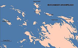
The Buccaneer Archipelago has many islands. Experts often group them by where they are located. Here are some of the main groups:
- North-east group: This includes Macleay Island, Conway Island, King Island, and Crabbe Island.
- South-east group: Here you'll find McIntyre, Bathurst, Irvine, Flora, Kathleen, Wangania, Tanner, Cockatoo, and Usborne Islands. Black Rock is also in this group.
- West group: This group has Caffarelli Island, Cleft Island, Fraser, Admiral, Bruen and King Hall, Longitude, Powerful Island, and many others.
- South-west group: This includes Bedford, Godsmark, Asshlyn, Goat, and Pope Islands.
The Encyclopaedia Britannica says there are "four clusters" of islands. It also mentions that Macleay Island is the largest island in the whole archipelago.
Here is a table with some of the islands in the Buccaneer Archipelago:
| Island | Area | Location |
|---|---|---|
| Admiral Island (Western Australia) | 16°04′00″S 123°24′06″E | |
| Bathurst Island (Western Australia) | 16°02′41″S 123°31′57″E | |
| Bedford Islands | 16°09′29″S 123°20′11″E | |
| Bruen Island | 16°04′00″S 123°22′45″E | |
| Byron Island (Buccaneer Archipelago) | 16°09′45″S 123°26′55″E | |
| Caffarelli Island | 2.12 km² (0.82 sq mi) | 16°02"36'S 123°16"48'E (lighthouse) |
| Cleft Island (Western Australia) | 16°02′16″S 123′21′01″E | |
| Cockatoo Island (Western Australia) | 16°05′55″S 123°37′00″E | |
| Fraser Island (Western Australia) | 16°03′28″S 123°21′51″E | |
| Goat Island (Western Australia) | ||
| Hidden Island | 19.7 km² (7.6 sq mi) | 16°13′32″S 123°28′03″E |
| Irvine Island | 9 km² (3.5 sq mi) | 16°04′35″S 123°32′14″E |
| King Hall Island | 16°04′52″S 123°24′29″E | |
| Koolan Island | 27.1 km² (10.5 sq mi) | 16°07′31″S 123°44′18″E |
| Long Island (Western Australia) | 11 km² (4.2 sq mi) | 16°34′26″S 123°22′11″E |
| Longitude Island | 16°03′34″S 123°24′01″E | |
| Powerful Island | 16°05′57″S 123°25′50″E | |
| Sunday Island (King Sound) | 13.3 km² (5.1 sq mi) | 16°24′25″S 123°11′13″E |
 | Georgia Louise Harris Brown |
 | Julian Abele |
 | Norma Merrick Sklarek |
 | William Sidney Pittman |


