Buffalo Gap, South Dakota facts for kids
Quick facts for kids
Buffalo Gap, South Dakota
pté tȟathíyopa otȟúŋwahe
|
|
|---|---|

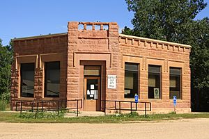
Buffalo Gap Town Hall, July 2011
|
|

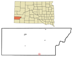
Location in Custer County and the state of South Dakota
|
|
| Country | United States |
| State | South Dakota |
| County | Custer |
| Area | |
| • Total | 0.31 sq mi (0.79 km2) |
| • Land | 0.31 sq mi (0.79 km2) |
| • Water | 0.00 sq mi (0.00 km2) |
| Elevation | 3,268 ft (996 m) |
| Population
(2020)
|
|
| • Total | 131 |
| • Density | 428.10/sq mi (165.50/km2) |
| Time zone | UTC-7 (MST) |
| • Summer (DST) | UTC-6 (MDT) |
| Zip Code |
57722
|
| Area code(s) | 605 |
| FIPS code | 46-08340 |
| GNIS feature ID | 1267303 |
Buffalo Gap is a small town in Custer County, South Dakota, United States. Its name in the Lakota is pté tȟathíyopa otȟúŋwahe, which means "buffalo gap village". In 2020, about 131 people lived there.
Contents
A Look at Buffalo Gap's Past
Buffalo Gap is a very old town in western South Dakota. It was started in 1877. By 1885, it was a busy stop for the Fremont, Elkhorn and Missouri Valley Railroad. Back then, over 1,200 people lived there. Today, the town is much smaller.
Why the Town's Size Changed
In its early days, Buffalo Gap was one of the biggest towns in South Dakota. But it faced a big challenge. A fire destroyed much of the town. This was similar to what happened in the Great Chicago Fire. The town never fully recovered or rebuilt to its earlier size.
Where the Name Comes From
The town's name comes from a gap in the land to its west. This gap used to be a safe place for large herds of buffalo. Even though Buffalo Gap has had fires, some old buildings are still standing.
Exploring the Area Around Buffalo Gap
Buffalo Gap is on State Highway 79. This road connects Hermosa and Hot Springs. You can also take County Road 656 from Buffalo Gap. This road leads to places like the Buffalo Gap National Grasslands, Badlands National Park, and the Pine Ridge Indian Reservation. A French book called La Brèche aux buffles even has parts of its story set in Buffalo Gap.
Geography of Buffalo Gap
Buffalo Gap is a small town. It covers about 0.31 square miles (0.79 square kilometers). All of this area is land. There are no large bodies of water within the town limits.
Who Lives in Buffalo Gap
| Historical population | |||
|---|---|---|---|
| Census | Pop. | %± | |
| 1910 | 280 | — | |
| 1920 | 132 | −52.9% | |
| 1930 | 183 | 38.6% | |
| 1940 | 182 | −0.5% | |
| 1950 | 186 | 2.2% | |
| 1960 | 194 | 4.3% | |
| 1970 | 155 | −20.1% | |
| 1980 | 186 | 20.0% | |
| 1990 | 173 | −7.0% | |
| 2000 | 164 | −5.2% | |
| 2010 | 126 | −23.2% | |
| 2020 | 131 | 4.0% | |
| U.S. Decennial Census | |||
In 2010, 126 people lived in Buffalo Gap. There were 66 households, which are groups of people living together. About half of these households were families. The average household had about two people.
A Closer Look at the Population
The average age of people in Buffalo Gap in 2010 was 53 years old. About 17% of the residents were under 18. About 25% were 65 years or older. There were more males (57%) than females (43%) living in the town.
Famous Person from Buffalo Gap
- Rex Putnam was born in Buffalo Gap. He later became the Oregon Superintendent of Public Instruction. This means he was in charge of public education in Oregon.
See also
 In Spanish: Buffalo Gap (Dakota del Sur) para niños
 | Emma Amos |
 | Edward Mitchell Bannister |
 | Larry D. Alexander |
 | Ernie Barnes |

