
Buiston Loch facts for kids
Quick facts for kids Buiston Loch |
|
|---|---|

Buiston Loch from near Lochside Farm
|
|
| Lua error in Module:Location_map at line 420: attempt to index field 'wikibase' (a nil value). | |
| Location | Kilmaurs and Stewarton, East Ayrshire, Scotland |
| Type | Drained freshwater loch |
| Primary inflows | Rainfall and runoff |
| Primary outflows | Garrier Burn |
| Catchment area | 800 by 1,700 m (2,600 by 5,600 ft) |
| Basin countries | Scotland |
| Max. length | 750 m (2,460 ft) |
| Max. width | 250 m (820 ft) |
| Surface area | 0.1475 km2 (0.0570 sq mi) |
| Max. depth | 6 m (20 ft) |
| Surface elevation | 90 m (300 ft) |
| Islands | One Crannog |
| Settlements | Stewarton |
Buiston Loch was once a freshwater lake in East Ayrshire, Scotland. It was located in a low-lying area, about 90 meters above sea level. The loch formed naturally in a hollow left behind by glaciers. Its waters flowed out through the Garrier Burn, which eventually joined the River Irvine.
This loch was drained a long time ago, in the early 1700s. Today, it's mostly just a field that sometimes floods. You can find this area near the A735 road, between the farms of Lochside, Buistonend, and Mid-Buiston.
Buiston Loch is famous because of a very old crannog found there. A crannog is an ancient artificial island. This one is about 2000 years old! It was first explored in 1880-1881 by a local teacher, Dr. Duncan McNaught, and others.
History of Buiston Loch

Old maps help us understand what Buiston Loch looked like. A map from 1654, made by Blaeu, showed it as a large, triangle-shaped lake. However, by the mid-1700s, the loch seems to have been drained.
By 1828, the Garrier Burn was still on maps, but it had been straightened into a canal. Drains were also added to the fields. This was likely part of a plan to improve the land for farming. Around 1830, someone described the loch area as a wet, boggy place in summer and a shallow lake in winter. By 1880, it had become a rich farm field. More drainage work happened around 1875.
Buiston Loch was a lake formed after the Ice Age. It was on land owned by a powerful family called the Earls of Eglinton. At first, people thought the crannog might have been a building made by the Earls for hunting birds. You can still see signs of the original shoreline on the north side of where the loch used to be.
Even though old maps show the area as fully drained and farmed, the drainage isn't working as well today (since 2011). This means the area often floods again, becoming a small lake during certain times of the year.
Why the Loch Was Drained
The draining of Buiston Loch might have started in the early 1700s. This was when Alexander Montgomerie, 10th Earl of Eglinton, was making many improvements to his large estates. More drainage work might have happened in the 1740s. This was done to give jobs to Irish workers from Montgomerie's estates during the Irish potato famines. Many drainage projects also took place after World War I, when soldiers returned home and needed work.
The Buiston Crannog

The crannog at Buiston Loch is roughly circular and was known as the 'Swan Knowe'. It was found in December 1880 by Duncan McNaught, a teacher from Kilmaurs. He noticed some "worked" timbers in a drainage ditch. He knew about another crannog site nearby, so he recognized what he had found.
The site was first dug up in 1880 and then more thoroughly in April 1881. Later, in 1989-1990, the site was explored again. This was part of a study by Historic Scotland to check how well crannogs in southwest Scotland were holding up. Amazing discoveries were made, including a rare hanging bowl from the 4th century, a dugout canoe, and two ancient ovens.
The Buiston crannog was used during four different time periods, from AD 1 to AD 525. This means people lived there before the Romans came to this area, during the time of the Damnonii tribe, and into the period of the Kingdom of Strathclyde. It seems three log boats or canoes were found. One from 1989-1990 was left at the site. Another was sadly lost in a fire at the Dick Institute in 1909. The third might still exist in the Hunterian Museum.
-
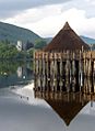
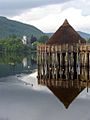
A reconstruction of a crannog in Loch Tay
-
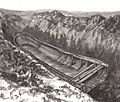
A canoe found at Buiston Loch
-
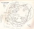
A plan of the Buiston Crannog site
-
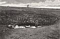
A view of the crannog during its excavation


Before the crannog was even identified, a lot of timber (thirteen cartloads!) had been taken away from the site. A local farmer once said, "There must have been dwellers here at one time," meaning people used to live there. The crannog was built using layers of turf, stones, branches, and tree trunks. No walkway was found leading to the crannog, which might have had one large round house built on it.

Images for kids
-
A reconstruction of a crannog in Loch Tay

