Bulahdelah, New South Wales facts for kids
Quick facts for kids BulahdelahNew South Wales |
|||||||||||||||
|---|---|---|---|---|---|---|---|---|---|---|---|---|---|---|---|

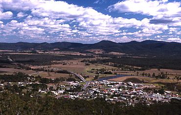
Bulahdelah seen from nearby hills
|
|||||||||||||||
| • Density | 5.6/km2 (15/sq mi) | ||||||||||||||
| Postcode(s) | 2423 | ||||||||||||||
| Elevation | 13 m (43 ft) | ||||||||||||||
| Area | 270.6 km2 (104.5 sq mi) | ||||||||||||||
| Time zone | AEST (UTC+10) | ||||||||||||||
| • Summer (DST) | AEDT (UTC+11) | ||||||||||||||
| Location | |||||||||||||||
| LGA(s) | Mid-Coast Council | ||||||||||||||
| Region | Mid North Coast | ||||||||||||||
| County | Gloucester | ||||||||||||||
| Parish | Willabah | ||||||||||||||
| State electorate(s) | Myall Lakes | ||||||||||||||
| Federal Division(s) | Lyne | ||||||||||||||
|
|||||||||||||||
Bulahdelah (/bʊləˈdiːlə/) is a friendly town located on the Mid North Coast of New South Wales, Australia. It's part of the Mid-Coast Council area. This town is known for its beautiful natural surroundings, including the Myall River and the famous Alum Mountain. It's a great spot for exploring nature and learning about local history!
Contents
Where is Bulahdelah?
Bulahdelah is about 235 kilometers (146 miles) north of Sydney. It sits along the eastern and northern banks of the Myall River. This river joins the Crawford River nearby. A special feature of the town is the Alum Mountain, which rises up on its eastern side.
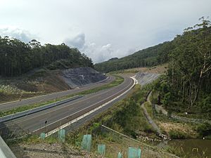
For many years, the main highway, the Pacific Highway, passed right through Bulahdelah. A large bridge over the Myall River, built in 1969, was part of this highway. However, in July 2013, a new section of the highway was built to go around the town. This bypass made the town quieter and safer for locals.
Bulahdelah's Past
What's in a Name?
The tall mountain next to Bulahdelah, which is 292 meters (958 feet) high, was first named by the local Aboriginal people, the Worimi. They called it "Boolah Dillah," which means "the Great Rock." Later, in 1818, a surveyor named John Oxley added "Mountain" to its name. Today, most people know it as "the Alum Mountain," but its official name is still Bulahdelah Mountain.
Mining History
The mountain is called "Alum Mountain" because a mineral called alunite was found there. Alunite is used to make alum, which has many uses, like in water purification and dyeing fabrics. Mining for alunite happened from 1878 to 1927, and again from 1934 to 1952. A special factory called "The Alum Works" was built to get the alum from the rock. Mining stopped in 1952 because it was no longer profitable. Since 1979, the NSW State Forests have managed the mountain.
Important Events
In 1892, a timber bridge was built across the Myall River. This was an important link for the town. Later, in 1969, a new two-lane concrete bridge replaced it.
In 1970, a very powerful tornado swept through the forests just north of Bulahdelah. It was one of Australia's most destructive tornadoes ever recorded.
Who Lives in Bulahdelah?
According to the 2016 Census, there were 1,424 people living in Bulahdelah. Most people (83.8%) were born in Australia. Also, most people (91.2%) spoke only English at home. When it came to religion, the most common choices were Anglican (30.3%), Catholic (23.3%), and No Religion (21.9%).
Fun Places to Visit
The Alum Mountain
The Alum Mountain stands tall over Bulahdelah. From its top, you can see amazing views of the area, from Cabbage Tree Mountain all the way to the coast. You can reach a special lookout by walking trails, or you can drive about two-thirds of the way up. You might even spot old mining equipment and blast caves from when the mountain was mined! There's also an old mining cart trail, known as "the trolley track," which is part of the mountain's history.
Cabbage Tree Mountain
This is an area of State forest that's great for outdoor adventures. You can go camping and hiking here. The Cabbage Tree Mountain ranges are easy to spot from Bulahdelah and the Alum Mountain.
Tops to Myall Heritage Trail
If you love exploring, the Tops to Myall Heritage Trail is a great option. This trail goes through the beautiful natural areas around Bulahdelah, offering a chance to learn about the local heritage and environment.
Local Industries
Logging Industry
For a long time, logging was a very important industry in Bulahdelah. People worked cutting down trees for timber. However, in 1994, much of the forest land became part of National Parks. This meant less logging could happen. Even so, logging still helped the town's economy in the early 2000s.
 | Delilah Pierce |
 | Gordon Parks |
 | Augusta Savage |
 | Charles Ethan Porter |


